Meatyorologist
-
Posts
8890 -
Joined
-
Last visited
-
Days Won
13
Everything posted by Meatyorologist
-
 Fantasy range GFS gets the memo
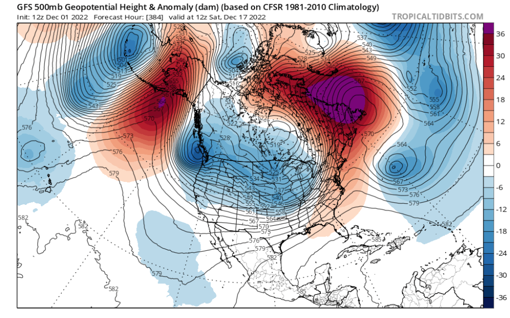
-
Also just a beautiful area in general.
-
From my grandma in Buckley!
-
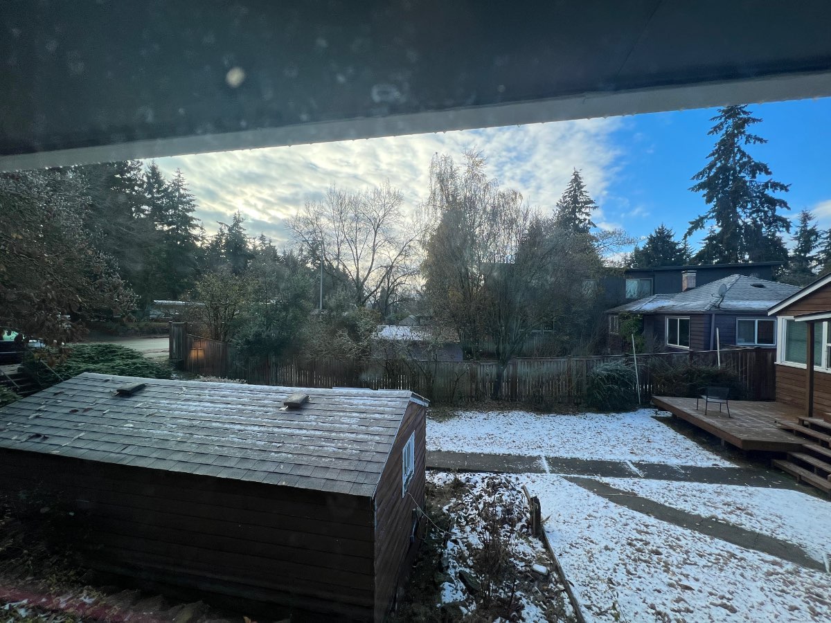
My place was just 5-10 miles north of the snow, kind of disappointing! But it's still really pretty outside. Frost and the remnants of Tuesday evening's snow are making things appear really wintry regardless. That and the warm lighting from the super low sun angles and a deep, jet blue sky that is only possible with an Arctic airmass. Really happy for the people south of Seattle that got snow last night. Nice to see the areas that got screwed Tuesday be rewarded for their patience. God only knows how lucky my place has been these last few years.... Even Tuesday we were nary 3 miles within the good side of an east wind boundary that kept us as snow longer than areas just to my south. More snow is coming Friday, and then much more this winter even if that doesn't work out. Plenty to be in good spirits about.

-
A good omen indeed!
-
Another great thing you noted yesterday was that arcing precipitation bands like the one incoming Friday usually end up displaced further north/east away from the low than modeled. Could mean more precip for much of the area. Euro looks like it catches onto this and is much juicier than the GFS.
-
It felt like it came with hardly any effort either... Significant cold anomalies piled up during almost every weather pattern this November had to offer as local climo beat out red 500mb height maps. We took advantage of clear nights, inversions, cold troughing, and even a light snowpack yesterday! Truly felt like a rare throwback month instead of a solid month that we had to squeeze out every last drop of potential for. It could have been much colder had the die fallen in an even slightly different configuration. Probably my favorite November since 2010.
-
November 2022 PNW weather Discussion. #NoRidgeNovember
Meatyorologist replied to Iceresistance's topic in West of the Rockies
I need to watch the goonies again -
November 2022 PNW weather Discussion. #NoRidgeNovember
Meatyorologist replied to Iceresistance's topic in West of the Rockies
@RentonHillTC Covering the Euro nightshift?! Awesome -
November 2022 PNW weather Discussion. #NoRidgeNovember
Meatyorologist replied to Iceresistance's topic in West of the Rockies
31F. -
November 2022 PNW weather Discussion. #NoRidgeNovember
Meatyorologist replied to Iceresistance's topic in West of the Rockies
It's certainly looking like less and less of a shutout for the Seattle area. I'm looking forward to radar in ~3-5 hours. -
November 2022 PNW weather Discussion. #NoRidgeNovember
Meatyorologist replied to Iceresistance's topic in West of the Rockies
Spin is becoming more visible on radar, and more sheets of stratoform rain are forming. Could be the beginning of round 2 for the south sound in a couple hours, maybe some more to the north? -
November 2022 PNW weather Discussion. #NoRidgeNovember
Meatyorologist replied to Iceresistance's topic in West of the Rockies
HRRR snowmaps are blank for tomorrow morning, but the column is semi-saturated and sfc temps are cold. Overall looks really weird and I don't trust it.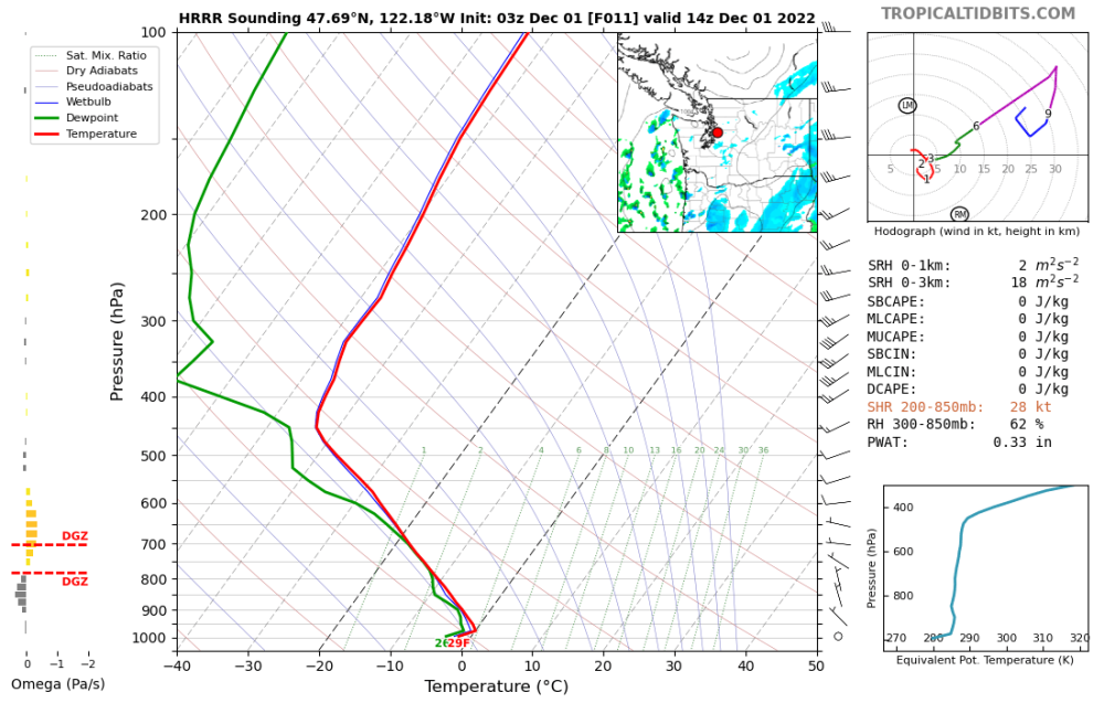
-
November 2022 PNW weather Discussion. #NoRidgeNovember
Meatyorologist replied to Iceresistance's topic in West of the Rockies
Looks primed for another Arctic event -
November 2022 PNW weather Discussion. #NoRidgeNovember
Meatyorologist replied to Iceresistance's topic in West of the Rockies
Deformation banding -
November 2022 PNW weather Discussion. #NoRidgeNovember
Meatyorologist replied to Iceresistance's topic in West of the Rockies
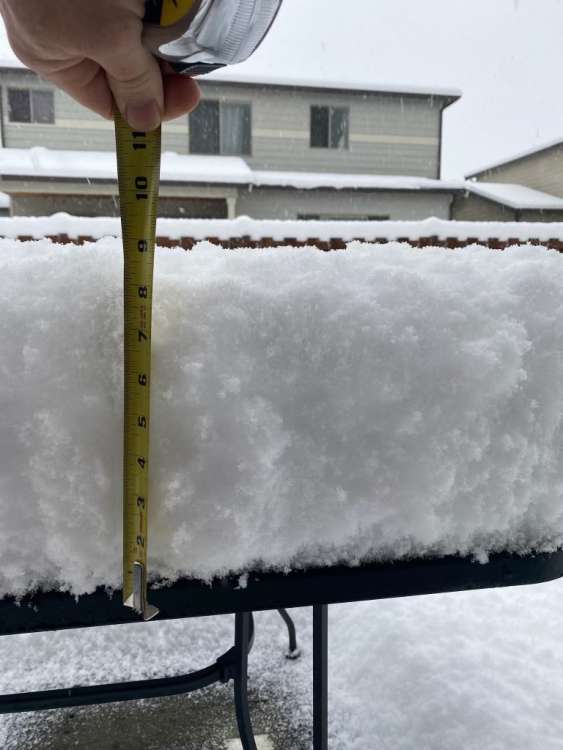
That forecast actually verified nicely at my place, but the windswept snow brought crazy drifting almost two feet deep in parts of the yard. -
November 2022 PNW weather Discussion. #NoRidgeNovember
Meatyorologist replied to Iceresistance's topic in West of the Rockies
That thing does not do well with deformation snowfall at all. Consistently and comically underdoes it. If it were to be believed, I would have received 3" in Feb 2019. Toss it. -
November 2022 PNW weather Discussion. #NoRidgeNovember
Meatyorologist replied to Iceresistance's topic in West of the Rockies
Posting about this in the twitter groupchat... What is offshore right now is convection enhanced by divergence aloft. That will stall and weaken gradually as it meanders onshore, if it even makes it to land. What the global models are so happy about tomorrow morning is a deformation band forming over the sound. That is a separate feature, as Jim has pointed out. That is the best chance for accumulating snowfall Seattle northward. -
November 2022 PNW weather Discussion. #NoRidgeNovember
Meatyorologist replied to Iceresistance's topic in West of the Rockies
Stellar cloud streets -
November 2022 PNW weather Discussion. #NoRidgeNovember
Meatyorologist replied to Iceresistance's topic in West of the Rockies
Best Dec -NAO in 12 years. Serious stuff. -
November 2022 PNW weather Discussion. #NoRidgeNovember
Meatyorologist replied to Iceresistance's topic in West of the Rockies
Even from a neutral perspective, that is a lot of Arctic blocking being depicted and there is opportunity written all over this. -
November 2022 PNW weather Discussion. #NoRidgeNovember
Meatyorologist replied to Iceresistance's topic in West of the Rockies
Not sure if this was posted. From last night's EPS.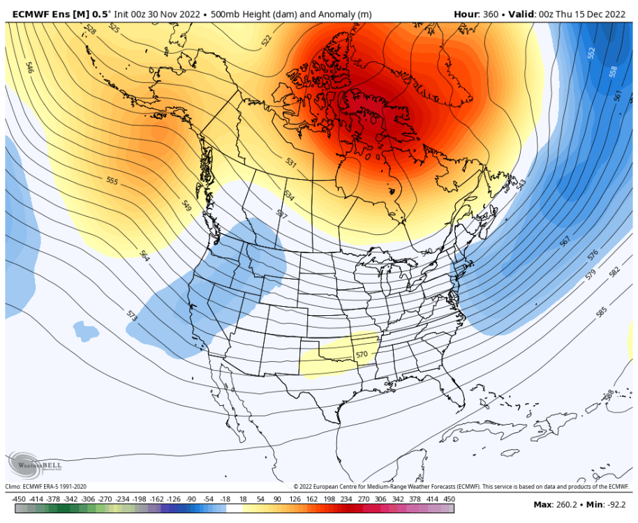
-
November 2022 PNW weather Discussion. #NoRidgeNovember
Meatyorologist replied to Iceresistance's topic in West of the Rockies
Offshore radar is juicy. I'm hoping! -
November 2022 PNW weather Discussion. #NoRidgeNovember
Meatyorologist replied to Iceresistance's topic in West of the Rockies
das some nice cyclogenesis -
November 2022 PNW weather Discussion. #NoRidgeNovember
Meatyorologist replied to Iceresistance's topic in West of the Rockies
NAM is definitley overdoing the sfc low. Entirely convection-driven and formed by the same bias that causes it to spawn mega-canes