SeanNyberg
-
Posts
334 -
Joined
-
Last visited
Everything posted by SeanNyberg
-

January 2024 Weather in the PNW (Part II)
SeanNyberg replied to Meatyorologist's topic in West of the Rockies
my God, this forum has devolved into the worst of the worst. It's always emotional and reactionary in here, but it seems that the rational and seasoned members have pulled back to make way for the kids. I'm going to step back for the day too. It's just too much uninformed nonsense. I am excited for a lot of you guys, because it seems like this is your first time tracking a PNW winter storm. I remember my first time. -
January 2024 Weather in the PNW (Part II)
SeanNyberg replied to Meatyorologist's topic in West of the Rockies
Yeah, it was pretty loud. Thank God no one was out and about -
January 2024 Weather in the PNW (Part II)
SeanNyberg replied to Meatyorologist's topic in West of the Rockies
Big branch down in my front yard from this morning’s winds. IMG_9549.mov -
January 2024 Weather in the PNW (Part II)
SeanNyberg replied to Meatyorologist's topic in West of the Rockies
Where? -
January 2024 Weather in the PNW (Part II)
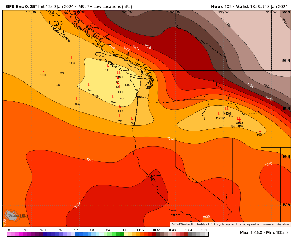
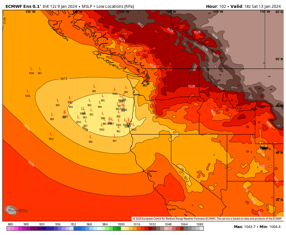
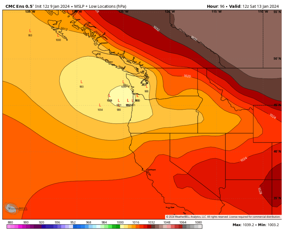
SeanNyberg replied to Meatyorologist's topic in West of the Rockies
The low placement among the three major model ensembles.

-
January 2024 Weather in the PNW (Part II)
SeanNyberg replied to Meatyorologist's topic in West of the Rockies
"I think the GFS OP is fundamentally misreading the entire situation over the NE Pacific. It needs to be thrown out." Based on what? What situation are you reading in the NE Pacific? and how is the GFS misreading it? It is such a bold and declarative statement, it seems weird. -
January 2024 Weather in the PNW (Part II)
SeanNyberg replied to Meatyorologist's topic in West of the Rockies
Gun to the head, bet the house, everything on the line, obviously the smart bet is to follow the Euro. It is just statistically more accurate. HOWEVER, and I think this is where a lot of you guys get lost, just because it is accurate more often, doesn't mean it is always more accurate. The GFS is a great model, even though we love to mock it. And it puts the low farther north for a reason. The Euro is a fabulous model and it puts the low farther south for a reason. Meaning, they could "show their work" and describe why they're guessing what they're guessing. It is not just made up out of nothing. There is a REASON the GFS wants to put it so far north. But there is also a REASON the Euro wants to drive it south. The Euro has a great track record, but it does screw things up sometimes. The GFS has a very good track record, but it too screws things up. So this is far from done. Both have been pretty consistent with their placement of the low. There are a number of things that the GFS has sniffed out before the other models in the run up, but the same could be said for the Euro. The point is (get to it already!) is that the uncertainty is real and not just wish casting. Just because the Euro has a better track record, doesn't mean it is always right, but it DOES have a better track record. So... knowing ONLY what we know now, if I was forced to bet, I would bet on the Euro SIMPLY based it's better track record. But would I do so confidently? No. Would I be shocked if I lost my bet and the GFS was more accurate? Not at all. Is this still pretty far away with a NUMBER of rare components at play for this region? Yes. This is the fun part. But disregard anyone who presents any model as gospel. The one thing I can guarantee is that the Thurs-Sunday period will NOT play out exactly as the Euro, GFS, or GEM are forecasting. But which will be closest? Time will tell! -
January 2024 Weather in the PNW (Part II)
SeanNyberg replied to Meatyorologist's topic in West of the Rockies
Why does it have to? -
January 2024 Weather in the PNW (Part II)
SeanNyberg replied to Meatyorologist's topic in West of the Rockies
That 3 hour snowfall rate is INSANE for an area like Seattle.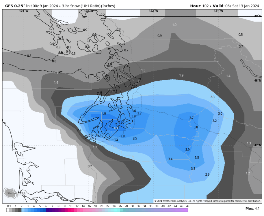
-
January 2024 Weather in the PNW (Part II)
SeanNyberg replied to Meatyorologist's topic in West of the Rockies
This event is really looking dynamic. I know we always knew that it would. But more and more features are popping up. The potential intensity and potential length add to everything else. Pretty exciting. -
January 2024 Weather in the PNW (Part II)
SeanNyberg replied to Meatyorologist's topic in West of the Rockies
I love how we keep pouring our expectations into a model (Euro) that had the entire region in the deep freezer (low teens) just a day or two ago, but now we're looking at many of those places sitting at or above freezing. Euro is struggling with this event. -
January 2024 Weather in the PNW (Part II)
SeanNyberg replied to Meatyorologist's topic in West of the Rockies
Yep! Enjoy -
January 2024 Weather in the PNW (Part II)
SeanNyberg replied to Meatyorologist's topic in West of the Rockies
And the problem with this forum (and this isn't personal, it's a general problem with PNW weather) is that Ups for some are Downs for others and vice versa. So... this event should provide for a good post-mortem -
January 2024 Weather in the PNW (Part II)
SeanNyberg replied to Meatyorologist's topic in West of the Rockies
I see. Yes, the Euro has definitely been pulled toward the GFS MUCH more than the GFS was pulled toward the Euro. We still have no clue how anything will play out. I mean, the Euro may totally cave to the GFS at the end, but then we may end up with 10 degree highs. So, it is funny to hear folks talk about which model was right or wrong, when ALL we have are wobbling models, we have no clue what is going to happen and no way to determine which model was actually right or wrong. (this last part has nothing to do with you, lol, just got tacked on to my reply) -
January 2024 Weather in the PNW (Part II)
SeanNyberg replied to Meatyorologist's topic in West of the Rockies
But that changes nothing regarding what I posted. -
January 2024 Weather in the PNW (Part II)
SeanNyberg replied to Meatyorologist's topic in West of the Rockies
00z Euro still pushing Seattle into the teens on Saturday. -
January 2024 Weather in the PNW (Part II)
SeanNyberg replied to Meatyorologist's topic in West of the Rockies
The Euro is... yes. But experience has shown that these things tend to have a hard time picking up light precipitation that can add up quickly. I know that you know that. Or that you know that I think that. LOL. So when I comment on your posts, I'm not directing it at you, I'm just adding some experiential context for the 300+ guests who are following along. -
January 2024 Weather in the PNW (Part II)
SeanNyberg replied to Meatyorologist's topic in West of the Rockies
Friday night into Saturday: Temps look to hold the same from the 00z run across the board. Euro is just bringing in the air a little later. -
January 2024 Weather in the PNW (Part II)
SeanNyberg replied to Meatyorologist's topic in West of the Rockies
This will fill in. It always does. -
January 2024 Weather in the PNW (Part II)
SeanNyberg replied to Meatyorologist's topic in West of the Rockies
12z Euro: Portland running 3-7 degrees warmer on Wednesday. Seattle -1 to +2 model to model change. -
January 2024 Weather in the PNW (Part II)
SeanNyberg replied to Meatyorologist's topic in West of the Rockies
They’ve all retreated slowly back to the gfs run after run. -
January 2024 Weather in the PNW (Part II)
SeanNyberg replied to Meatyorologist's topic in West of the Rockies
Yes. This will look more like the gfs in terms of snow than the drier euro from yesterday. The 12+ inches is likely overdoing it. But the trace to 2 inches is way too low: The other maps will start filling in shortly -
January 2024 Weather in the PNW (Part II)
SeanNyberg replied to Meatyorologist's topic in West of the Rockies
Why is it the gfs that is causing the disparity? Maybe it’s the icon that’s smoking. They’ve all been creeping toward the gfs the last few runs. GEM and EURO both had us in the low teens only two days ago and that’s completely off the table now. They’re the ones that seem crazy in retrospect. -
January 2024 Weather in the PNW (Part II)
SeanNyberg replied to Meatyorologist's topic in West of the Rockies
To be clear. This has been a hugely positive shift for Seattle and surrounding areas. sure a single digit freeze would be fun for a day. But I’ll take 30 and snowy any day. i know I know. Euro doesn’t show the snow!! It’s there. I promise. Been doing this long enough. Gfs was on to it the entire time. So Washingtonians. Dont let your Oregon brethren get you down. This has multi day epic snow storm written all over it. Champagne should be popping. oh. And that is why weather underground shows that snow for Bothell, because it’s coming. -
January 2024 Weather in the PNW (Part II)
SeanNyberg replied to Meatyorologist's topic in West of the Rockies
If that were to happen, those gaps would be filled as well. I can't count how many times I've seen this leading up to an event and it starts with bleeding in maybe 1" the day before, and then finally updates it with 5+ inches as it snows on the HRR