

bainbridgekid
-
Posts
6884 -
Joined
-
Last visited
-
Days Won
24
Everything posted by bainbridgekid
-

March 2024 Weather in the PNW
bainbridgekid replied to TigerWoodsLibido's topic in West of the Rockies
@TT-SEA Euro is slower to come out on Pivotal. What's it showing for highs Saturday and Sunday? -
March 2024 Weather in the PNW
bainbridgekid replied to TigerWoodsLibido's topic in West of the Rockies
5 straight months averaging over 109 degrees and two months with lows over 101 is diabolical. Especially since I'm sure AC is very rare there. Can't even imagine living in that. -
March 2024 Weather in the PNW
bainbridgekid replied to TigerWoodsLibido's topic in West of the Rockies
Booked my first tee times of the year for Friday after work and Sunday afternoon and I'm skiing Stevens on Saturday. Told my friends to expect 50 degree sunshine on the slopes and to golf in shorts on Sunday. Gotta make the most of times like this.- 6147 replies
-
- 11
-

-

-
March 2024 Weather in the PNW
bainbridgekid replied to TigerWoodsLibido's topic in West of the Rockies
Euro spits out 69 Sat and 68 Sun for PDX. Oddly it shows 69 both days for Everett though. Would be weird for us to be warmer than you in a pattern like this. If we are near 70 like that I would think mid 70's would be very achievable down there. Mark's 77 forecast at this range definitely feels click baity though. -
March 2024 Weather in the PNW
bainbridgekid replied to TigerWoodsLibido's topic in West of the Rockies
12z Euro fully on board with temps near 70 both Saturday and Sunday. Low 70's in the foothills Saturday. Perfectly timed with peak warmth over the weekend and if things break down sooner with some mountain snow later next week that's best of both worlds IMO..thumb.png.972d785fb95e78b2fcdde7e9c698e37f.png)
-
March 2024 Weather in the PNW
bainbridgekid replied to TigerWoodsLibido's topic in West of the Rockies
Hailing while the sun shines here. Dynamic. -
March 2024 Weather in the PNW
bainbridgekid replied to TigerWoodsLibido's topic in West of the Rockies
40 mph in Everett and 36 at SEA. -
March 2024 Weather in the PNW
bainbridgekid replied to TigerWoodsLibido's topic in West of the Rockies
We just had two weeks of much colder than normal weather including one of the coldest first weeks of March ever, had multiple minor lowland snow events, TONS of mountain snow AND still have 4 more stormy, cool days with feet of mountain snow to get through before the ridge. A week of nice, sunny, warm weather after that isn't hard to put a positive spin on. -
March 2024 Weather in the PNW
bainbridgekid replied to TigerWoodsLibido's topic in West of the Rockies
Agreed. The mountain melt off is being vastly overplayed IMO. Especially since they'll get like two feet this weekend and early next week before the ridge builds in. 50 and sunny with dry air and not much wind doesn't have a big impact on the snowpack..thumb.png.20682394a8a43c2aae8955b15e3b960b.png)
-
March 2024 Weather in the PNW
bainbridgekid replied to TigerWoodsLibido's topic in West of the Rockies
There's a lot of people that would argue water isn't actually wet, but that it just makes other things wet. https://www.sciencefocus.com/science/is-water-wet -
March 2024 Weather in the PNW
bainbridgekid replied to TigerWoodsLibido's topic in West of the Rockies
Next weekend should be great. Hoping to Spring ski one day and golf for the first time this season the other. -
March 2024 Weather in the PNW
bainbridgekid replied to TigerWoodsLibido's topic in West of the Rockies
Dry air makes all the difference. BLI is 37 but the DP is 28, so it makes sense the snow isn't very wet. Same reason frost or snow on the ground wouldn't be melting much in those conditions, but if it were 34 with a DP of 34 it would be. -
March 2024 Weather in the PNW
bainbridgekid replied to TigerWoodsLibido's topic in West of the Rockies
One lives in Enumclaw and the other lives in Olympia. You might be right about the thermometer. Could be a combination of fewer clear calm nights than normal and a finicky thermometer. Or maybe they moved it closer to a runway? Doubt that though. -
March 2024 Weather in the PNW
bainbridgekid replied to TigerWoodsLibido's topic in West of the Rockies
My girlfriend lives in Olympia close to OLM and I've been shocked by how mild it's been when I've visited this Fall and Winter. I expected way more frosty cold nights but there's been a lot of cloudy, foggy mornings in the mid-upper 30's even when much of the rest of Western WA was fairly clear and frosty. -
March 2024 Weather in the PNW
bainbridgekid replied to TigerWoodsLibido's topic in West of the Rockies
Arlington pulled off a string of lows of 26, 22, and 23 the last three days. Pretty impressive for March.- 6147 replies
-
- 10
-
-

-
March 2024 Weather in the PNW
bainbridgekid replied to TigerWoodsLibido's topic in West of the Rockies
The 12z GFS gives a large portion of the Olympics 5 feet of snow this weekend. Great to see them catching up. Their snowpack was absolutely abysmal till a few weeks ago. -
March 2024 Weather in the PNW
bainbridgekid replied to TigerWoodsLibido's topic in West of the Rockies
Yeah for sure. It can make a big difference anywhere in certain situations. My point was just that on this side of the mountains a few hundred feet make a noticable difference like 75% of the time (arctic fronts and overrunning events coming out of arctic events are the only real exceptions) while in the Gorge and Fraser it's probably less than 50% of the time. -
March 2024 Weather in the PNW
bainbridgekid replied to TigerWoodsLibido's topic in West of the Rockies
It makes a big difference everywhere in the Pacific Northwest. I've always figured that each 100 feet in elevation gain makes about a 15% increase in average snowfall. That means each 500 feet pretty much exactly doubles expected snow in a given year. The reason it makes such a huge differnece here compared to most of the rest of the country is the temperature is almost always right around freezing for our potential snow events. That's just as true in the Willammete Valley as around Puget Sound. Only exception really is up the Fraser River Valley North of Bellingham and well East of Portland deeper into the Gorge where there is more contintental influence during snow events and elevation often doesn't matter. -
March 2024 Weather in the PNW
bainbridgekid replied to TigerWoodsLibido's topic in West of the Rockies
Nice to see so much detail, but wow locating a city on there is going to be very difficult for the general public. -
March 2024 Weather in the PNW
bainbridgekid replied to TigerWoodsLibido's topic in West of the Rockies
Did SEA record snow last night? Sure hope so. Was clear from webcams the ground was white there. -
March 2024 Weather in the PNW
bainbridgekid replied to TigerWoodsLibido's topic in West of the Rockies
Cool map, but the color scheme kills me. Why would they make 0-14" all represented by seven different shades of orange? -
March 2024 Weather in the PNW
bainbridgekid replied to TigerWoodsLibido's topic in West of the Rockies
I'll be very surprised if the top of West Seattle didn't get about 2". It goes up over 500 feet there. -
March 2024 Weather in the PNW
bainbridgekid replied to TigerWoodsLibido's topic in West of the Rockies
Still hammering the South half of Seattle but it's progress North has slowed to a crawl. Good news for those getting hit but I doubt it moves North past Shoreline at all. -
March 2024 Weather in the PNW
bainbridgekid replied to TigerWoodsLibido's topic in West of the Rockies
Ground quite white at SEA. Hopefully they got out and recorded some snow officially.
-
March 2024 Weather in the PNW
bainbridgekid replied to TigerWoodsLibido's topic in West of the Rockies
These cams are 9 blocks apart in Everett.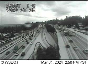
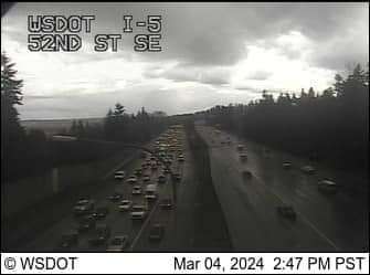


.png.83bbfc37cde0fbf9f02695eb9ab108da.png)

.png.8d3ced3eee8008641a857ba2d1087e4c.png)


