bainbridgekid
-
Posts
6880 -
Joined
-
Last visited
-
Days Won
24
Everything posted by bainbridgekid
-

February 2024 Weather in the PNW
bainbridgekid replied to TigerWoodsLibido's topic in West of the Rockies
39 mph gust earlier at SEA. Seems like a decent chance they break 40 mph at some point today. -
February 2024 Weather in the PNW
bainbridgekid replied to TigerWoodsLibido's topic in West of the Rockies
I swear they changed some parameter that completely messed that up. It never used to throw out massive foot+ snowstorms for the Coast and lowlands but now that happens regularly when nothing close to that has any chance of happening. I wonder if they adjusted some boundary layer issues in an attempt to improve snow forecasts in continental climates but it messed up snow forecasts here near the Coast. Seems especially egregious in cold onshore flow patterns like this where the models just assumed nearly all precip in the mid-upper 30's will fall as accumulating snow. -
February 2024 Weather in the PNW
bainbridgekid replied to TigerWoodsLibido's topic in West of the Rockies
He does this to a lot of people. He just enjoys being a pest. Best to ignore him. -
February 2024 Weather in the PNW
bainbridgekid replied to TigerWoodsLibido's topic in West of the Rockies
Total snow combining the Thursday night and Friday night events. Fascinating cutoff between the West and East side of Puget Sound. Can't say I've ever seen that happen before.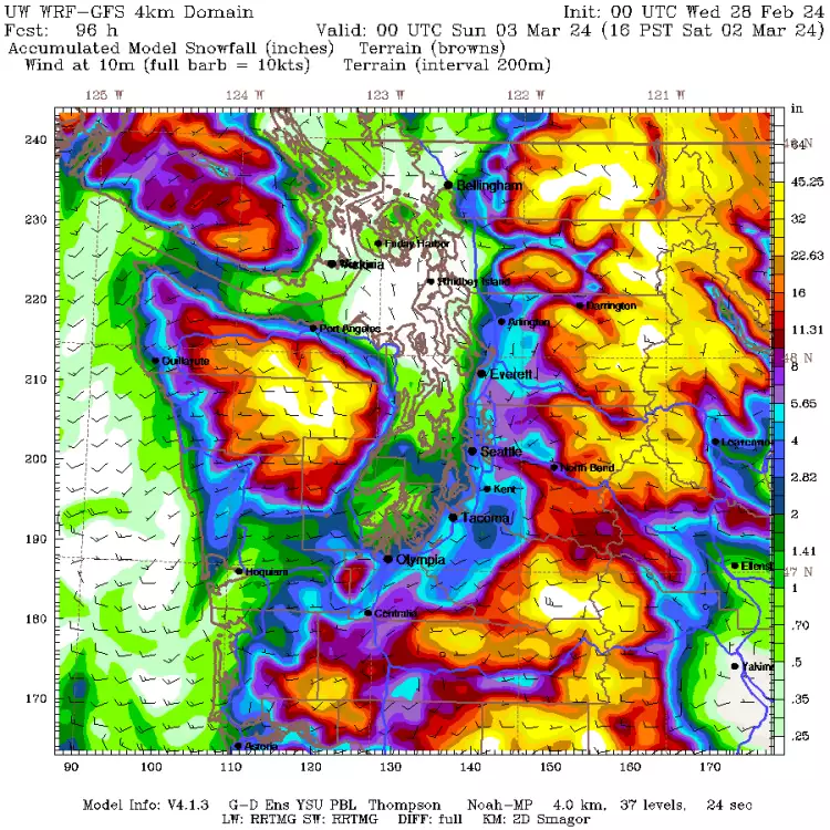
-
February 2024 Weather in the PNW
bainbridgekid replied to TigerWoodsLibido's topic in West of the Rockies
And that first map doesn't include this other snow Thursday night. The timing on these maps don't overlap.
-
February 2024 Weather in the PNW
bainbridgekid replied to TigerWoodsLibido's topic in West of the Rockies
WRF drops the hammer Friday night. Widespread 3-5" East of Puget Sound in Snohomish and King Counties. This would require perfectly threading the needle for both timing and strength of that band but nice to see the top end potential.
- 8823 replies
-
- 11
-

-

-

-

-

-
February 2024 Weather in the PNW
bainbridgekid replied to TigerWoodsLibido's topic in West of the Rockies
And in the opposite direction snow immediately started sticking even to roads here yesterday afternoon while the temp was still 38 degrees because the upper levels were very cold (850mb temps near -9) and snow was heavy and a bit groupely. Flakes must have been well below freezing till the lowest 1,000 feet or so. -
February 2024 Weather in the PNW
bainbridgekid replied to TigerWoodsLibido's topic in West of the Rockies
Not sure your first sentence is true if the DP remains below freezing. I've seen relatively dry snow fall with zero melting while the temp is 33 plenty of times if the air starts out fairly dry in evaporative cooling events. Forecasting snow amounts is so fascinatingly difficult because there are so many factors to nail down (exact temp and humidity through the air column and exact location and strength of every band of snow.) Crazy how much harder that is to forecast than rain. -
February 2024 Weather in the PNW
bainbridgekid replied to TigerWoodsLibido's topic in West of the Rockies
I find when accumulating snow actually happens it tends to be relatively close to 10:1 here. But the 10:1 map way overestimates how often that happens and shows lots of phantom snow that never happens at all. Kuchera ends up being closer in borderline setups not because the accumulating snow all falls at Kuchera's low ratio but because it eliminates a lot more of the phantom snow. -
February 2024 Weather in the PNW
bainbridgekid replied to TigerWoodsLibido's topic in West of the Rockies
.thumb.png.a345afe016fe78642d2ddd59397ba2f3.png)
-
February 2024 Weather in the PNW
bainbridgekid replied to TigerWoodsLibido's topic in West of the Rockies
Widespread overrunning snow Sunday night too on the 00z GFS.
-
February 2024 Weather in the PNW
bainbridgekid replied to TigerWoodsLibido's topic in West of the Rockies
Fun little guy Friday night on the 00z GFS brings some bands of moderate to heavy snow through especially in the South Sound.
-
February 2024 Weather in the PNW
bainbridgekid replied to TigerWoodsLibido's topic in West of the Rockies
He must have been looking at an old run or different night. This is lows tomorrow night when the snow supposedly falls..thumb.png.be9f265321498fadb7e95dc03e34b2ec.png)
-
February 2024 Weather in the PNW
bainbridgekid replied to TigerWoodsLibido's topic in West of the Rockies
3km NAM flips King County to heavy wet snow tomorrow night with decent accumulations South of I-90 and East of 405..thumb.png.2f25037a03ce3eeb85a10d53334bbfc6.png)
-
February 2024 Weather in the PNW
bainbridgekid replied to TigerWoodsLibido's topic in West of the Rockies
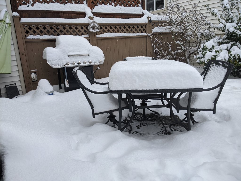
Friend in Mill Creek got 5" just NW of Clearview, but there was a very sharp cutoff on both the North and South side of the CZ. On my drive to work in Mountlake Terrace this morning it went from snow covered roads to zero snow on the ground in a couple miles. -
February 2024 Weather in the PNW
bainbridgekid replied to TigerWoodsLibido's topic in West of the Rockies
I have a FB Weather group and two people reported 7" last night with pictures. One was near Freeland on Whidbey Island and the other was near Sultan along US-2. I bet the very center of that CZ probably got 10" in a few small spots with how narrow and stationary it was. -
February 2024 Weather in the PNW
bainbridgekid replied to TigerWoodsLibido's topic in West of the Rockies
18z GFS got rid of the Saturday night snow for Puget Sound, but replaced it with more snow Friday night and Sunday night. Going to be very difficult tracking things the next week with how many different meandering weak systems come through here. -
February 2024 Weather in the PNW
bainbridgekid replied to TigerWoodsLibido's topic in West of the Rockies
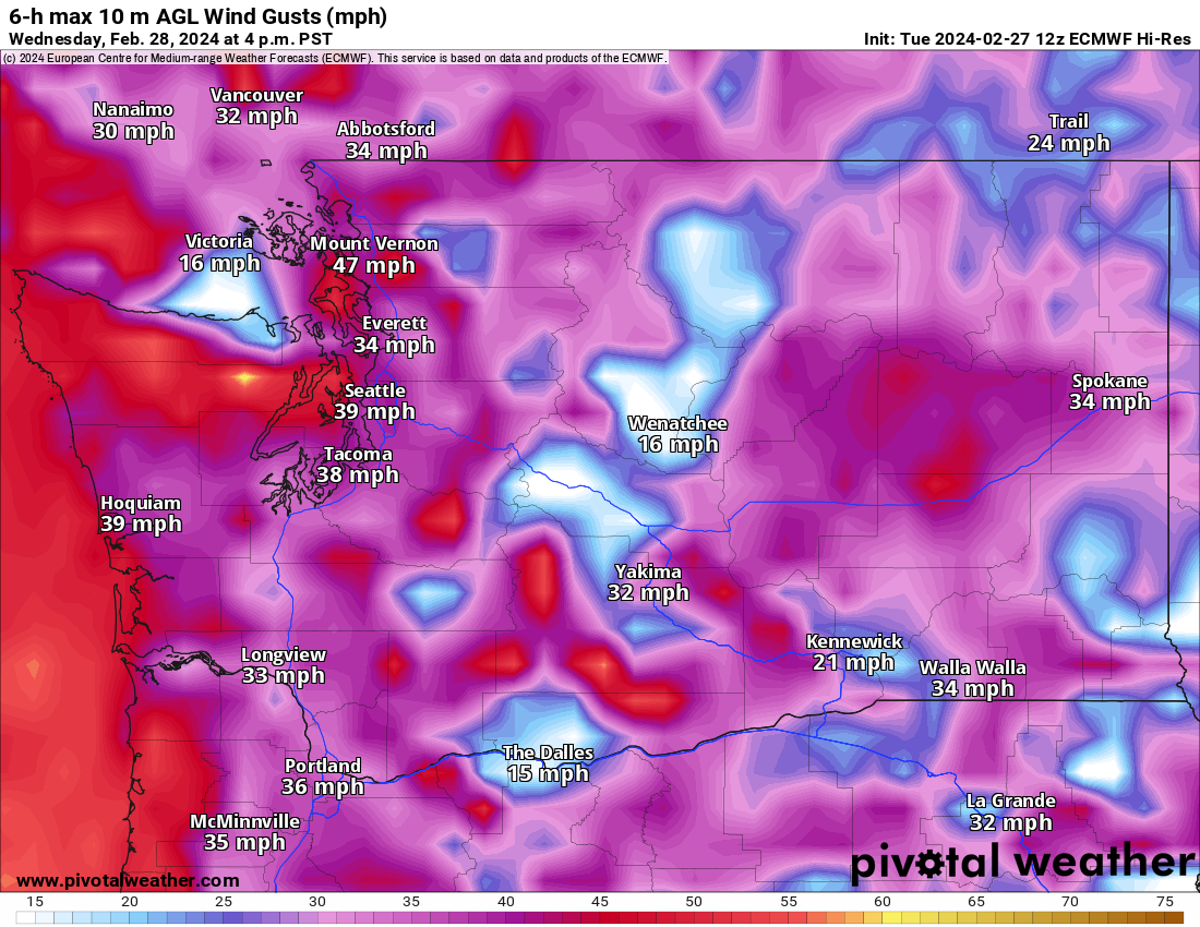
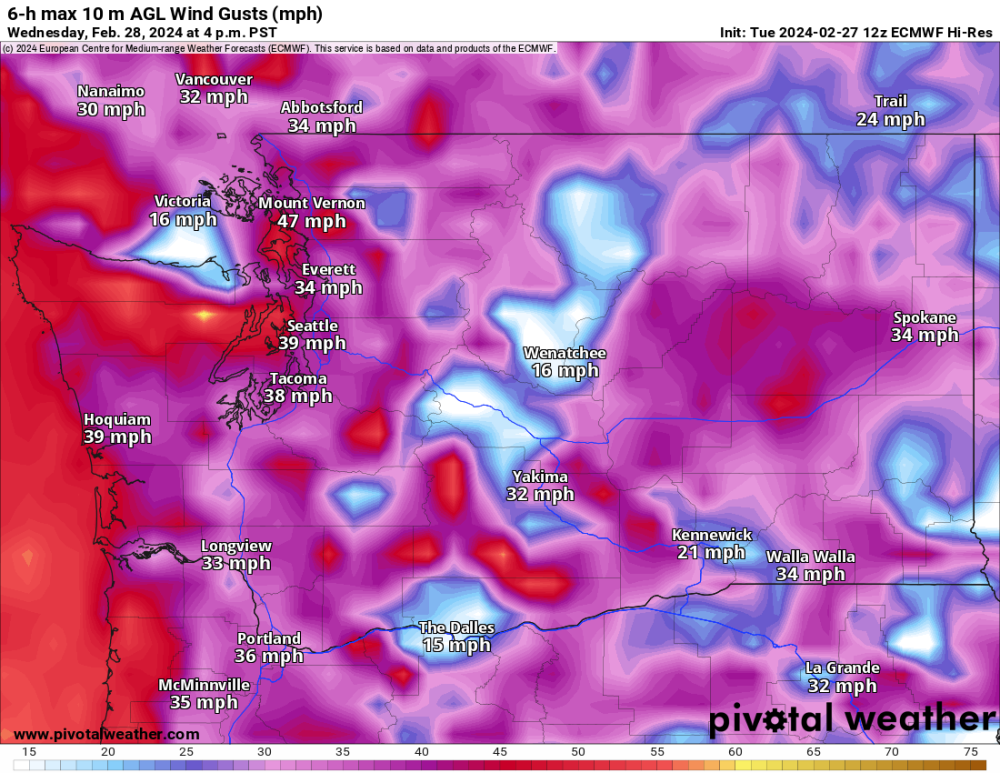
Impressive temp drop tomorrow night behind the cold front on the 3km NAM. Really sharp visible cold front. It also shows 47 mph gusts in Seattle tomorrow afternoon around 3 PM.
-
February 2024 Weather in the PNW
bainbridgekid replied to TigerWoodsLibido's topic in West of the Rockies
Tomorrow looks sneaky stormy with nearly an inch of rain and 30-45 mph wind. Might also be fun tracking the snow level falls on the backside of this system tomorrow night..thumb.png.83b1413a64d5fcac1239857d4738b96f.png)
-
February 2024 Weather in the PNW
bainbridgekid replied to TigerWoodsLibido's topic in West of the Rockies
Anecdotal, but it feels like the Winter jet stream has been weaker and the Four Corners High in the Summer has been stronger the last decade or so. That would make some sense with a warmer Arctic weakening the Jet Stream and more warmth building in the lower latitudes in the Summer. -
February 2024 Weather in the PNW
bainbridgekid replied to TigerWoodsLibido's topic in West of the Rockies
Forecasting this week will be particularly hard because there are several disorganized systems and blobs of moisture rotating through and tracking the exact strength, location, and timing of each of them will be nearly impossible. Wouldn't matter if temps weren't going to be near freezing some of the time, but as it is any of them could drop a quick 1-3" of snow just about anywhere if timed right during the night. Thursday night and Saturday night look like the most real threats at this point to me. -
February 2024 Weather in the PNW
bainbridgekid replied to TigerWoodsLibido's topic in West of the Rockies
6z Euro 10:1 ratio map gives you 7" Thursday night. Kuchera gives you 1". -
February 2024 Weather in the PNW
bainbridgekid replied to TigerWoodsLibido's topic in West of the Rockies
WRF Thursday night snow.
-
February 2024 Weather in the PNW
bainbridgekid replied to TigerWoodsLibido's topic in West of the Rockies
.gif.acf2f2188e05e54cf32c6b6b0da4dba7.gif)
-
February 2024 Weather in the PNW
bainbridgekid replied to TigerWoodsLibido's topic in West of the Rockies
Interesting setup over the weekend with this weak low tracking South of Seattle. 12z GFS hammers the South and Central Sound with a narrow band of heavy wet snow. Kuchera map gives SEA 7".
- 8823 replies
-
- 10
-


.png.133217f0b3c85db834e18c78a491ca08.png)

.png.bd0035c11723f298b0e81aa68047cbe2.png)
.png.33671cb320396bcbb3d8fff0c6b4305a.png)
.png.501ab24533109a36e61a021d00f0490d.png)