


clintbeed1993
-
Posts
868 -
Joined
-
Last visited
Recent Profile Visitors
2411 profile views


clintbeed1993's Achievements
")


-
Man, this is the kind of night I love. One of those nights when you get round after round of storms, usually during late spring and summer. Many in Northern MO and Southeast NE are getting 2 to 3 or more inches of rain with training storms. These are areas that have been bone dry the last couple months and are in a pretty bad drought. Much needed. Last part of March also looks to hold more precip chances. Good to see things changing to a more active pattern in the plains
-

January 2024 Observations and Discussion
clintbeed1993 replied to Minny_Weather's topic in East of the Rockies
That map is seasonal snowfall not current snow depth -
As beautiful as that looks, the HRRR and RAP models are basically useless outside 12 hours from the event
-
I assumed they weren't able to make that distinction very well. The cool thing for me is I can chase snowstorms. My parents live up in Aurora, NE while I live in Saint Joseph, MO. Usually Aurora gets more snow so I can just drive there and enjoy the bigger totals and if once in a blue moon Northern MO gets a better snow, I can cash in on that too!
-
I don't think the models are able to pick up on the warm thermals down in northern MO. NWS is saying it will stay a mix for most of the event now and only have a few inches of accumulation forecasted, while models and especially the ensembles are extremely bullish with two to three times that. Does anyone know if models typically can't account for the mix and show it as all snow when it won't be?
-
Talk about anti climatic
-
January 2024 Observations and Discussion
clintbeed1993 replied to Minny_Weather's topic in East of the Rockies
Look at the literal middle finger over my backyard. WTSF -
00z GFS is literally a dream run for central NE, and it looks almost identical to the Christmas 2009 blizzard that stalled and wrapped snow into the area all day. Wow, LOCK THAT IN
-
DECEMBER 2023 Observations and Discussion
clintbeed1993 replied to Grizzcoat's topic in East of the Rockies
I can't think of much worse than cold rain on Christmas..yuck! We need to get cold air into this pattern ASAP The cruel joke is this is actually turning into December 2009 only with zero cold air. Could be looking at multiple massive rain storms with barely a flake thanks to the torch -
August 2023 Observations and Discussion
clintbeed1993 replied to westMJim's topic in East of the Rockies
Another heat wave looks likely for early September...really pissing me off -
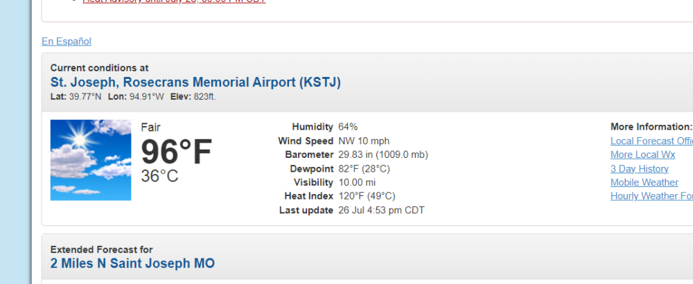
Edit, apparently the heat index in Saint Joseph is now 120..I have NEVER seen that at my location. WTF is this garbage
-
The heat index is 116 in my town today...that is absolutely ridiculous. We're paying for the lack of heat to this point. Looks like this heatwave has legs and will last through next week
-
Not off to a good start when the previous storms likely forecast for overnight disappeared. Color me skeptical on much happening later today, at least in Northern MO. You might get the redevelopment down there. Hot and muggy with no rain is literally the worst
-
Seems like things are blowing up further northeast than they were forecasted to in Nebraska. I might have a shot of a really good MCS down in Saint Joe MO later tonight. Fingers crossed
-
NWS blend literally just had the entire area in central Nebraska getting 4-6 inches from this current system and look how that went. What a joke. Wouldn't trust any of these models a week out


