


uticasnow
-
Posts
97 -
Joined
-
Last visited
Everything posted by uticasnow
-
January 11-13 Major Winter Storm/Blizzard
uticasnow replied to Hoosier's topic in East of the Rockies
Of course Macomb County not included the Winter Storm Watch..................................
-
January 11-13 Major Winter Storm/Blizzard
uticasnow replied to Hoosier's topic in East of the Rockies
Of course the southeastern part is not included as it will change to RAIN once again,...and again...and again -
January 11-13 Major Winter Storm/Blizzard
uticasnow replied to Hoosier's topic in East of the Rockies
Total EURO Snow through hour 84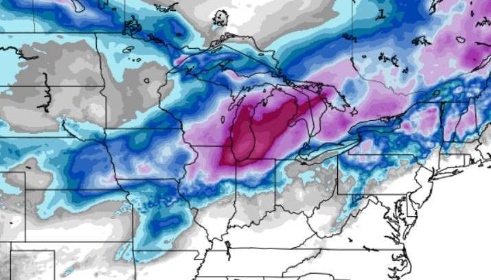
-
January 11-13 Major Winter Storm/Blizzard
uticasnow replied to Hoosier's topic in East of the Rockies
EURO HOUR 60 SLAM!
-
January 11-13 Major Winter Storm/Blizzard
uticasnow replied to Hoosier's topic in East of the Rockies
CMS HR 96 (10:1)
-
January 11-13 Major Winter Storm/Blizzard
uticasnow replied to Hoosier's topic in East of the Rockies
GFS Hr 84
-
January 11-13 Major Winter Storm/Blizzard
uticasnow replied to Hoosier's topic in East of the Rockies
GFS Hr 78
-
January 11-13 Major Winter Storm/Blizzard
uticasnow replied to Hoosier's topic in East of the Rockies
GFS 72hr
-
January 11-13 Major Winter Storm/Blizzard
uticasnow replied to Hoosier's topic in East of the Rockies
Hour 66 On GFS
-
January 11-13 Major Winter Storm/Blizzard
uticasnow replied to Hoosier's topic in East of the Rockies
I hear ya!. Same old story down here. I guess we have the lakes to our east to thank for screwing us over everytime. -
January 11-13 Major Winter Storm/Blizzard
uticasnow replied to Hoosier's topic in East of the Rockies
ICON goes crazy for southeast Michigan but then changes to SUPRISE! (RAIN! ) -
January 11-13 Major Winter Storm/Blizzard
uticasnow replied to Hoosier's topic in East of the Rockies
Come ON!...We need this is southeast Michigan. Only a trace of snow so far this season. It's been pathetic -
January 11-13 Major Winter Storm/Blizzard
uticasnow replied to Hoosier's topic in East of the Rockies
I thought the map showed 8.4" in northwestern Indiana -
January 11-13 Major Winter Storm/Blizzard
uticasnow replied to Hoosier's topic in East of the Rockies
Can someone post maps? -
Detroit was hinting thisi morning that temps are trending a little cooler than previously forecast: A forecast trend from 24 hour ago has been for a slight delay precipitation onset. It is quite possible that snow will hold off until after the morning commute particularly north of M 59 and/or I 69 corridors. The other change has been for a slightly cooler atmosphere column by a degree or two Celsius. As a result, there is lower confidence on when precipitation will changeover to rain. Given the projected UVV response, more efficient wet bulb cooling could delay the changeover to rain by an hour or two. Thus, preference is to carry snow accumulations through noon for many areas particularly in the higher elevation of the Irish Hills
-
is The Euro trending southeast?
-
Actually it started trending north 4+ days ago from when we first started tracking the storm
-
Yes
-
I know alot of people are dissapointed by this storm, but in all reality the thermal profiles and lack of cold air was known well before all the hoopla took place.
-
January 11-13 Major Winter Storm/Blizzard
uticasnow replied to Hoosier's topic in East of the Rockies
Lock it in!. It will only change 100 times between now and then! -
Same old story for us in SE MI. Fun to watch the models, but in all reality it ends up rain, or a slopfest.
-
This shows 10-1 ratios but reality is you can probably cut these totals in half with the warmth
-
Not here in southeast Michigan. Was lookig pretty good for a half way decent snowfall with this upcoming storm but as always ends up being mostly rain.........what a dissapointment (again).
-
January 2024 Observations and Discussion
uticasnow replied to Minny_Weather's topic in East of the Rockies
For us in southeast Michigan there is no sense in getting excited because the WARM air takes over almost 90% of the time! -
Didn't see the same post til I looked at mine!


