kush61
-
Posts
38 -
Joined
-
Last visited
Everything posted by kush61
-
Cha Cha Cha... GFS went from High pressure to to Low pressure at Lake Erie on the 8th, why such a drastic invert ?
-
Salute and Salutations fellow Weather Geeks. Longtime lurker from Ontario Canada here. We'll be travelling to Long Point (North shore of Lake Erie across from Erie Pennsylvania) to witness the eclipse. Just wondering if anyone can post cloud cover map updates leading up to the event along the path of totality ? ...Or suggest where one can navigate the internet to find such maps ? Thank - you...
-
 Snow forecasted to begin falling here at 10:00 am Friday Was out and about on a tadpole trike cruising across multiple neighbor's snow covered fields like they were troweled cement. Frozen solid and smooth except for where the sled's had left their bumpy tracks. Did this once in the early 80's in Toronto, On. Again around 2001 in Waterdown, On. and..... tonight 2023, in Lynden On. Canada. Up to 20 cm possible (yah... right!) Warnings 10:55 PM EST Thursday 09 March 2023 Snowfall warning in effect for: City of Hamilton Significant snowfall expected Friday. Hazards: Snow with total accumulations of 10 to 15 cm. Local snowfall amounts of 15 to 20 cm over higher terrain. Visibility may be reduced at times in heavy snow and local blowing snow.
 -
2/21 - 2/24 Powerhouse Upper Midwest/GL's Winter Storm
kush61 replied to Tom's topic in East of the Rockies
It's been snowing lightly since 7:00am, intensified late this afternoon. Was able to get out on the sled for a ride, strong East winds 4 - 6 " accumulation. jaster220 must have a closet full of towels to throw in, he's not spared us his presence yet !!!! -
So..... What ??? .....because it's not "IMBY" it's not worth watching ? There's a storm coming and many are to be effected from it. Please no "lock it in" and wish casting, just the facts !!!
-
I've been watching next storm (Fleur)? appear/disappear/appear on the GFS for a week now. It targets my location on a Friday-13th on which dates Motorcycle Rally's are held in Port Dover, Ontario (32 miles due South of my location) similar to Sturgis, South Dakota just not at the same scale. The Main street will be shut down to vehicular traffic and venders are to set up but attendance may be affected by the weather. Next Friday 13th is in October. This storm is computer forecast to become massive as it approaches the east coast.

-
Pre-Christmas Storm Plains/MW/GL 12/21-12/22
kush61 replied to bud2380's topic in East of the Rockies
Another lurker here. Cold front forecasted to come through my area at the crack of noon. I'll be out doors waiting for it !.thumb.png.e17fae6b6df1e2a4d7cc0c67b660afc8.png)
-
Pre-Christmas Storm Plains/MW/GL 12/21-12/22
kush61 replied to bud2380's topic in East of the Rockies
Awwwww !!! Grasshopper... (Money) ...those are the very right questions !!! Very educational, thank you !!! No "crossing fingers" or "lock it in" wish cast statements wasting valuable forum bytes . Merry Memorial Christmas Storm 2022. -
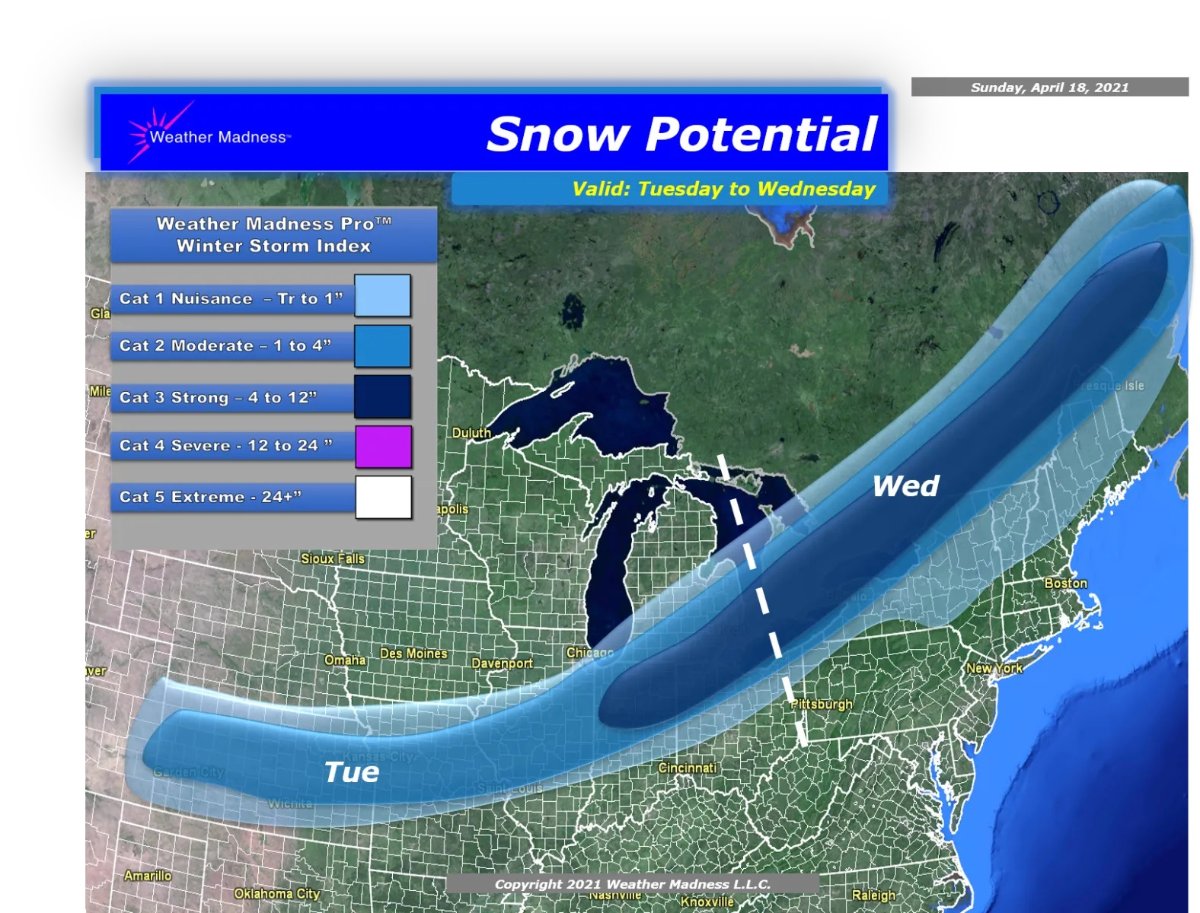
Henry Margusity "Weather Madness" prediction...
-
Wednesday morning was very cold, sunny and calm and very tranquil with the chirping of birds from all directions... This morning isn't as cold but cloudy, breezy East wind and not a bird to be heard !
-
Valentines and Presidents Day Oklahoma and Mid West Smasher.
kush61 replied to Clinton's topic in East of the Rockies
Is there to be any "thunder snow" accompanying this system ? Last time that happened in this vicinity was Jan. 14 1999, Mel Lastman called in the army to help shovel ! -
Valentines and Presidents Day Oklahoma and Mid West Smasher.
kush61 replied to Clinton's topic in East of the Rockies
... and an almost identical track for another storm later this week ? -
Valentines and Presidents Day Oklahoma and Mid West Smasher.
kush61 replied to Clinton's topic in East of the Rockies
STOP your whining !!! What is a whiny person? Whiny describes someone who annoyingly complains or frets about something, especially in a high-pitched voice. YUP !!! That sounds like you. \\\\\ Discard your computer and its internet access to computer models.... here is your new Weather Stone forecasting tool !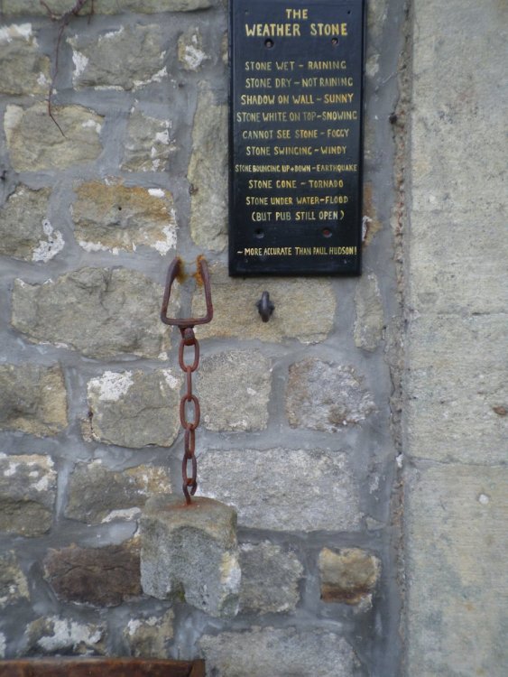
-
Happy Groundhog Day everyone. Well... I hate to burst this Winters bubble but I heard a Robin chirping away at 7:15am this morning whilst walking the dogster !!! What do they know about the upcoming weather patterns ?
-
Enjoy your snowfall and remember to lift with the legs not the back. At one point 87 million people were affect by a Winter Storm Warning/Watch for Arlena. I'm an exclusion ! But it was a great night for AM radio reception, I pulled in 1630 KCJJ, Napoleon Street Southeast + Sand Road Southeast Cedar Rapids, 588.79 miles East of me.
-
I have a question... Is the LPC drifting North or will it pass South of Lake Erie as it continues East ?
-
Henry Margusity's model interpretations and nice graphics he's generated.

-
Not referring to present system... Just though this phenomenon is very interesting and will impact North American weather in 7 days. Will computer models be able to assimilate for this extreme analogy ? https://www.severe-weather.eu/global-weather/pacific-record-breaking-extratropical-storm-mk/ Embedded content: https://players.brightcove.net/1942203455001/B1CSR9sVf_default/index.html?videoId=6219300818001
-
Well isn't this special ? Big warm-up in January !!! https://www.severe-weather.eu/global-weather/pacific-record-breaking-extratropical-storm-mk/ A monster is born, tracking a record-breaking low approaching the U.S.
-
DECEMBER 23-26 Potential storm for SW Great Lakes
kush61 replied to kush61's topic in East of the Rockies
Alerts for: City of Hamilton Warnings 4:36 AM EST Thursday 24 December 2020 Snowfall warning in effect for: City of Hamilton A snowfall of 10 to 20 cm is expected tonight. Hazards: 10 to 20 cm of snow Quickly accumulating snow at times Timing: This evening through Friday mid-morning Impacts: Poor road conditions due to black ice and snow accumulation Discussion: Temperatures will fall this afternoon and rain will transition to snow. The snow may become heavy at times this evening and overnight, with snowfall rates of 2 to 3 cm per hour possible at times. Snow should gradually ease into scattered flurries Friday morning. Some uncertainty remains regarding total snowfall amounts, however, for much of the Niagara Region and areas just west, it appears 15 cm is likely enough to warrant a snowfall warning. Note: Environment Canada's criteria for Snowfall Warnings is 15 cm of snow in 12 hours or less. Rapidly accumulating snow could make travel difficult over some locations. Aww geeze... I'll be able to get the sled out for a run. -
DECEMBER 23-26 Potential storm for SW Great Lakes
kush61 replied to kush61's topic in East of the Rockies
Let it snow, let it snow, let it snow !!! Merry Christmas. -
DECEMBER 23-26 Potential storm for SW Great Lakes
kush61 replied to kush61's topic in East of the Rockies
Can anyone guide me in obtaining a GFS surface map of North America from Jan. 02 1999 ? That's the last time we had "thunder snow" out this way, along with a 12" snowfall. I'd like to compare it to this map. The "massive trowal like signature" of the occluded front sounds interesting. Found this "old school" video that is almost as old as I am. The Occluded Front - Air Masses And Fronts (1962) - YouTube.URL -
DECEMBER 23-26 Potential storm for SW Great Lakes
kush61 replied to kush61's topic in East of the Rockies
Earlier models didn't predict the low that develops over the SW states on the 24th. Why does it materialize as the original one that entered the West Coast fizzles away ? What happened with the anafront ? -
DECEMBER 23-26 Potential storm for SW Great Lakes
kush61 replied to kush61's topic in East of the Rockies
Sorry for starting this thread too soon. I've never started one before and didn't realize a week out was too soon. I just wanted input on the track of that cyclone. The members of this forum are a great source of weather expertise that I appreciate. Thank-you all !!! Received about an inch of snow here overnight. -
Hello... Any thoughts about a possible Low Pressure Center crossing the SW Great Lakes just ahead of Christmas. Will it transpire; if so, with rain or snow ?


.png.c8da9c066f72a5c3735fccc592ccf0f0.png)