Gradient Keeper
-
Posts
27986 -
Joined
-
Last visited
-
Days Won
164
Everything posted by Gradient Keeper
-

December 2019 Weather Discussion for the PNW
Gradient Keeper replied to Timmy Supercell's topic in West of the Rockies
Day 2 -
December 2019 Weather Discussion for the PNW
Gradient Keeper replied to Timmy Supercell's topic in West of the Rockies
00z GFS Day 1 -
December 2019 Weather Discussion for the PNW
Gradient Keeper replied to Timmy Supercell's topic in West of the Rockies
Just a temporary blip right now before models key in on this pattern change. Much colder runs coming soon. It's coming. Soon. Twice. The first visitation and then it comes back again. Yeah. -
December 2019 Weather Discussion for the PNW
Gradient Keeper replied to Timmy Supercell's topic in West of the Rockies
North Pacific view
-
December 2019 Weather Discussion for the PNW
Gradient Keeper replied to Timmy Supercell's topic in West of the Rockies
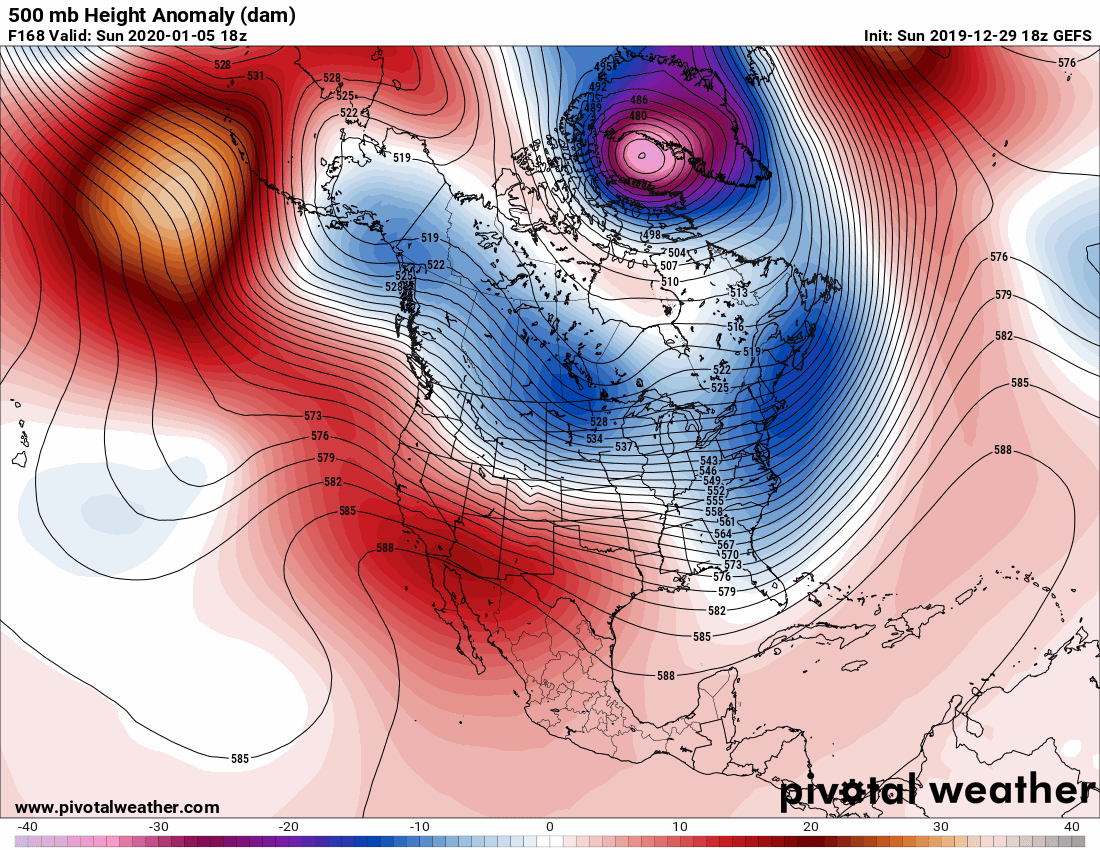
18z GEFS 500mb Height Anomaly - Day 7 to 16 Before anyone starts to doubt the potential ahead or is discouraged after some downturns with a few GFS Op/Ensembles runs watch the loop. Look how stable the pattern is with a massive Gulf of Alaska/Eastern Aleutian Block and persistent Southeastern/Eastern US ridge. We are quite close to going straight into a cold, possibly arctic air pattern with reloads and snow(moisture dependent). It all depends on the upstream trough over the Sea of Okhotsk/Western Bering Sea, and downstream with the Southeastern US ridge and its amplitude. Don't lose hope yet. Models could easily trend back in our favor. Cautiously optimistic. C'MON!!!!
-
December 2019 Weather Discussion for the PNW
Gradient Keeper replied to Timmy Supercell's topic in West of the Rockies
If you believe in the Kona, Kona will believe in you. Okay, that sounded stupid. Yeah. Anyhow. B E L I E V E and the Kona will happen. BUT everyone must do so. It's just that simple. Sort of. -
December 2019 Weather Discussion for the PNW
Gradient Keeper replied to Timmy Supercell's topic in West of the Rockies
18z GEFS was an unfortunate huge step backwards, but not entirely. Looking at 850mb ensembles shows a more progressive pattern in the short-mid term. I don't like that. Nothing cold long range and much worse for Yakima, no cold air source. Barf. Drunk Uncle has been WAY too sober this Holiday season! C'MON!!!! He has clearly given all of his stash to his brother 6z. Obviously. However, the 500mb pattern is not far off whatsoever with a Gigantic Gulf of Alaska/Eastern Aleutian block and persistent Southeast ridge with Bitter air in BC/AB. Will 00z continue this or bring us back from the cliff edge? No idea. Stay tuned! 00z GFS in 3 hours 57 minutes 00z GEM in 4 hours 17 minutes 00z ECMWF in 6 hours 12 minutes -
December 2019 Weather Discussion for the PNW
Gradient Keeper replied to Timmy Supercell's topic in West of the Rockies
Either the models are clueless, or we are cluelessly clueless of the models cluing clued clues. -
December 2019 Weather Discussion for the PNW
Gradient Keeper replied to Timmy Supercell's topic in West of the Rockies
Oh really? That would be a game changer. -
December 2019 Weather Discussion for the PNW
Gradient Keeper replied to Timmy Supercell's topic in West of the Rockies
As others have mentioned the Day 6-7 trough is colder. Sub 522 thickness PDX, 850s -8c. PDX-EUG light gradient -2 to -3mb. Snow level 750-500' at times. Overnight into morning hours slushy snow nearly everywhere is likely. It would be nice if that played out. After day 8-10 500mb pattern clearly better than 12z. It's close to greatness and even losing the initial Kona low still doesn't change the overall evolution with the Gulf of Alaska/Eastern Aleutian block. Good things ahead! YEAH! C'MON!!!! 00z GFS in 4 hours 37 minutes Think Cold and SNOW!!!! C'MON!!!! ❄ ❄ ☃ ❄ ❄ -
December 2019 Weather Discussion for the PNW
Gradient Keeper replied to Timmy Supercell's topic in West of the Rockies
00z runs brings the madness back! (In a good way) -
December 2019 Weather Discussion for the PNW
Gradient Keeper replied to Timmy Supercell's topic in West of the Rockies
Only 4-5 days away from the point the kona low may develop. Not a lot of time left for models to waver back and forth on whether or not it develops. Won't be resolved until I think Monday 00z perhaps Tuesday runs. IF we trend back to the Kona we're in store for a lot of Cold and........ Snow? .... 00z ECMWF in 10 hours 6 minutes -
December 2019 Weather Discussion for the PNW
Gradient Keeper replied to Timmy Supercell's topic in West of the Rockies
Day 10-15 on the EPS should shape up pretty nice. -
December 2019 Weather Discussion for the PNW
Gradient Keeper replied to Timmy Supercell's topic in West of the Rockies
12z EURO Op Day 8-10 for PDX is cold and snowy on Day 10. Only 10 days out! -
December 2019 Weather Discussion for the PNW
Gradient Keeper replied to Timmy Supercell's topic in West of the Rockies
Day 10 that block is setup nearly perfect for great things. -
December 2019 Weather Discussion for the PNW
Gradient Keeper replied to Timmy Supercell's topic in West of the Rockies
Euro saved the day! Looks pretty cold for us. -
December 2019 Weather Discussion for the PNW
Gradient Keeper replied to Timmy Supercell's topic in West of the Rockies
Day 10 -
December 2019 Weather Discussion for the PNW
Gradient Keeper replied to Timmy Supercell's topic in West of the Rockies
Day 10 -
December 2019 Weather Discussion for the PNW
Gradient Keeper replied to Timmy Supercell's topic in West of the Rockies
The million dollar question is, how different will 00z run be tonight? 12z GFS = Horrible. 12z GEFS = Worsened. 12z GEM = not great. 12z Canadian Ensembles = Pretty good. 12z EURO = Quite decent, but a few potential bad trends, but also close to being very good. 12z EPS ???? -
December 2019 Weather Discussion for the PNW
Gradient Keeper replied to Timmy Supercell's topic in West of the Rockies
Day 9 cold -
December 2019 Weather Discussion for the PNW
Gradient Keeper replied to Timmy Supercell's topic in West of the Rockies
Day 9 -
December 2019 Weather Discussion for the PNW
Gradient Keeper replied to Timmy Supercell's topic in West of the Rockies
Day 8 -
December 2019 Weather Discussion for the PNW
Gradient Keeper replied to Timmy Supercell's topic in West of the Rockies
What a rollercoaster of model riding the past 24 hours. -
December 2019 Weather Discussion for the PNW
Gradient Keeper replied to Timmy Supercell's topic in West of the Rockies
Day 8 is very different. Do not like that cut-off between the two ridges at all. Cut-off bias showing? -
December 2019 Weather Discussion for the PNW
Gradient Keeper replied to Timmy Supercell's topic in West of the Rockies
Day 7 Meh. UGH!