Jack_GradStudent
-
Posts
83 -
Joined
-
Last visited
Jack_GradStudent's Achievements
")


-
Dynamically, this absolutely looks like a severe outbreak producer.. but that morning moisture shown in the gfs over northenr ar/southern mo worries me a bit. Euro deterministic would actually lead to better potential for a tornado outbreak due to it not becoming a cut off low and the surface low not occluding. Places better orthogonal deep layer shear over the area too.
-
Pre-Christmas Storm Plains/MW/GL 12/21-12/22
Jack_GradStudent replied to bud2380's topic in East of the Rockies
I actually started to notice a trend in the GEFS and Euro mean. HRRR is higher res so it can resolve it better. -
Pre-Christmas Storm Plains/MW/GL 12/21-12/22
Jack_GradStudent replied to bud2380's topic in East of the Rockies
I'm even hesitant to call it storm snowfall totals wise. The winds and temps are making it one, though, for sure. -
Pre-Christmas Storm Plains/MW/GL 12/21-12/22
Jack_GradStudent replied to bud2380's topic in East of the Rockies
This storm is like predicting the exact locations of spotty showers-- the global models don't have the resolution to resolve what this event will really end up looking like-- some with a dusting, some with 5 inches! -
Pre-Christmas Storm Plains/MW/GL 12/21-12/22
Jack_GradStudent replied to bud2380's topic in East of the Rockies
https://whatgoesonoutside.com/a-white-christmas-for-most-and-dangerous-cold/ Hard to believe it, but areas between KC, Topeka, and St, Joe may see no snow at all. Here are my latest thoughts for the KC area! -
Pre-Christmas Storm Plains/MW/GL 12/21-12/22
Jack_GradStudent replied to bud2380's topic in East of the Rockies
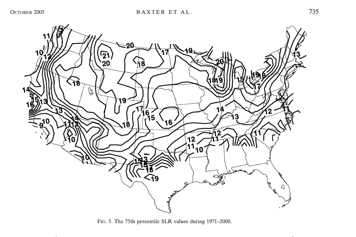
This is from a research article of a climatology of snow to liquid ratios for the entire conus between 1971-2000. Obviously, with these cold temperatures, snow to liquid ratios will be higher, but I post this to warn against just going with the Kuchera snow maps. This is a map of not the mean ratios, but the 75th percentile meaning what would likely be the higher end of ratios for a snow event. Much of Kansas, Missouri, Iowa, and Illinois is in the 14-15:1 range. Climatology suggests that even in the more extreme events like this one, you can't necessarily bank on 20:1 + snow to liquid ratios. Another aspect to think about is how strong the winds will be which will likely breakdown the dendrites as they fall through the atmosphere. Just some thoughts...
-
Pre-Christmas Storm Plains/MW/GL 12/21-12/22
Jack_GradStudent replied to bud2380's topic in East of the Rockies
Areas to the north and east have a much better chance... even if the storm gets its act together a bit quicker, it would first benefit those areas before the KC area. We would have to see a fairly large trend for snow totals to go up. -
Pre-Christmas Storm Plains/MW/GL 12/21-12/22
Jack_GradStudent replied to bud2380's topic in East of the Rockies
Any one deterministic model run that shows higher totals needs to be suspect at this point.. there's no point in paying any attention to the canadian that spits out 3 inches more than what the rest of the guidance is saying.. QPF across a wide range has been going down the past 48 hours. Now if ensemble probabilities start to lurch upward, that would be one thing, but 25th-75th percentiles have been going down consistently... to me it's looking like most places outside of the great lakes regions may be under warning criteria snow totals wise. -
Pre-Christmas Storm Plains/MW/GL 12/21-12/22
Jack_GradStudent replied to bud2380's topic in East of the Rockies
Never heard of the super ensemble. -
Pre-Christmas Storm Plains/MW/GL 12/21-12/22
Jack_GradStudent replied to bud2380's topic in East of the Rockies
After several model runs, my prediction of 2-5 inches for the KC metro hasn't budged one bit. The only way KC--Columbia--STL area can see more than that is if the upper level system can start maturing and begin to take that negative tilt much further west.. I definitely don't see that happening though. We won't really see a classic "comma head" or deformation band; it's really just going to be broad area of lift generated by the cold front at the surface and some strong mid-level dynamics and vorticity advection. QPF has been honing on the 0.15-0.35 range.. which is why I'm going with 2-5 inches..NBM also reflects this range with its 25th-75th percentile outputs. Yes I know the rain-snow ratios are going to be quite high, but not necessarily for entire period that it's snowing because the temps will be crashing as it begins.Was reading this from EAX tonight.. I am not sure what data is showing evidence of a half an inch of QPF.. thats a 90th percentile solution. I really think this 4-6 inches forecast is too high for Pleasant Hill CWA. Tuesday/Wednesday will be full of looking for little wiggles and twists this storm may have.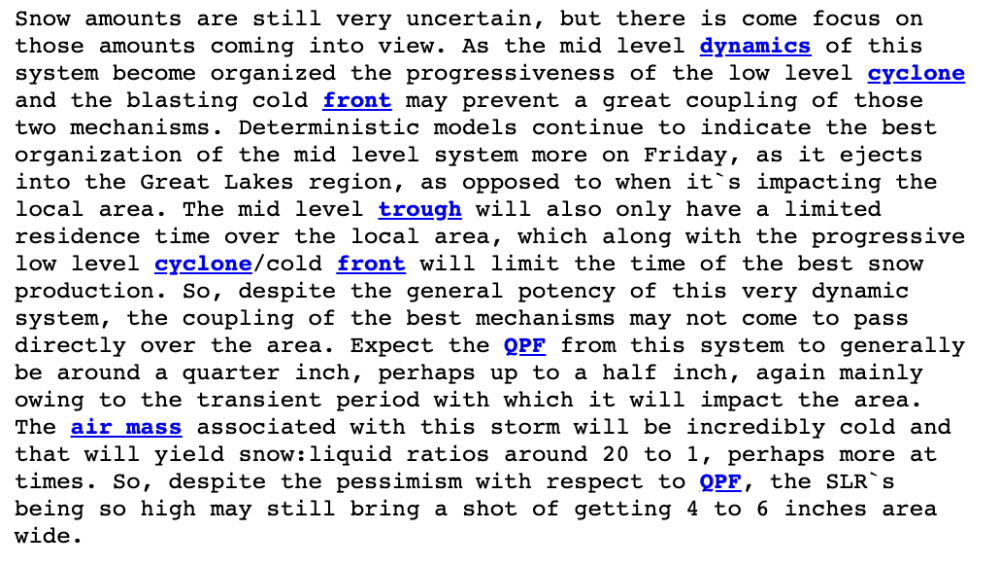
-
Pre-Christmas Storm Plains/MW/GL 12/21-12/22
Jack_GradStudent replied to bud2380's topic in East of the Rockies
Did anyone else get a bit frustrated reading the AFD from Pleasant Hill? During a week where at least some accumulating snow is possible, you'd think there would be more mention of it. Sure, the cold needs to be highlighted but I would have liked to see a bit more analysis regarding the precipitation possible from this system.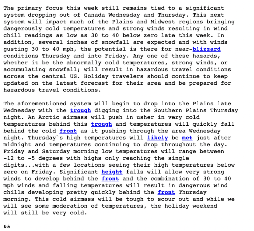
-
Pre-Christmas Storm Plains/MW/GL 12/21-12/22
Jack_GradStudent replied to bud2380's topic in East of the Rockies
That Christmas was awesome.. that was the best Christmas present my 10 year old self could ask for. I remember there being close to foot where I live in Johnson County. That storm had it all in terms of precip type and think it was the first time I had every experienced a blizzard warning. -
Pre-Christmas Storm Plains/MW/GL 12/21-12/22
Jack_GradStudent replied to bud2380's topic in East of the Rockies
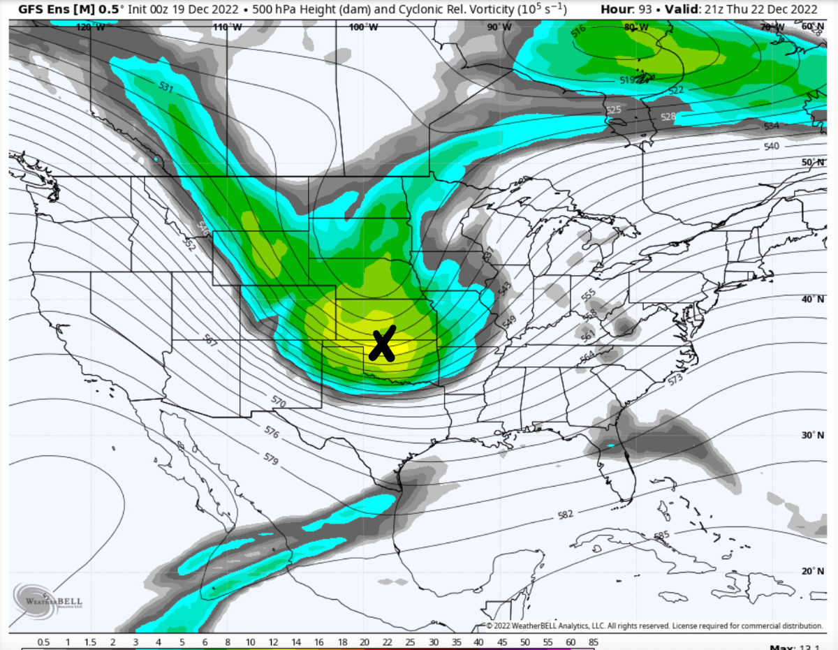
Definitely do not like this trend I'm seeing in the GEFS for the Kansas/Missouri area.. Last night I said I wish I was seeing these kind of runs on Wednesday rather than Sunday.. also mentioned that GFS run had to be considered an anamoly and this kind of trend is exactly why. GEFS shows a system that isn't diving nearly southwest as we want it at least in the central part of the U.S. I highlighted the vorticity maximums in the latest GEFS run and last nights 0z run.. drastic differences. I think anything above 2 inches in is KC suspect. Hoping to see a trend back further SW soon.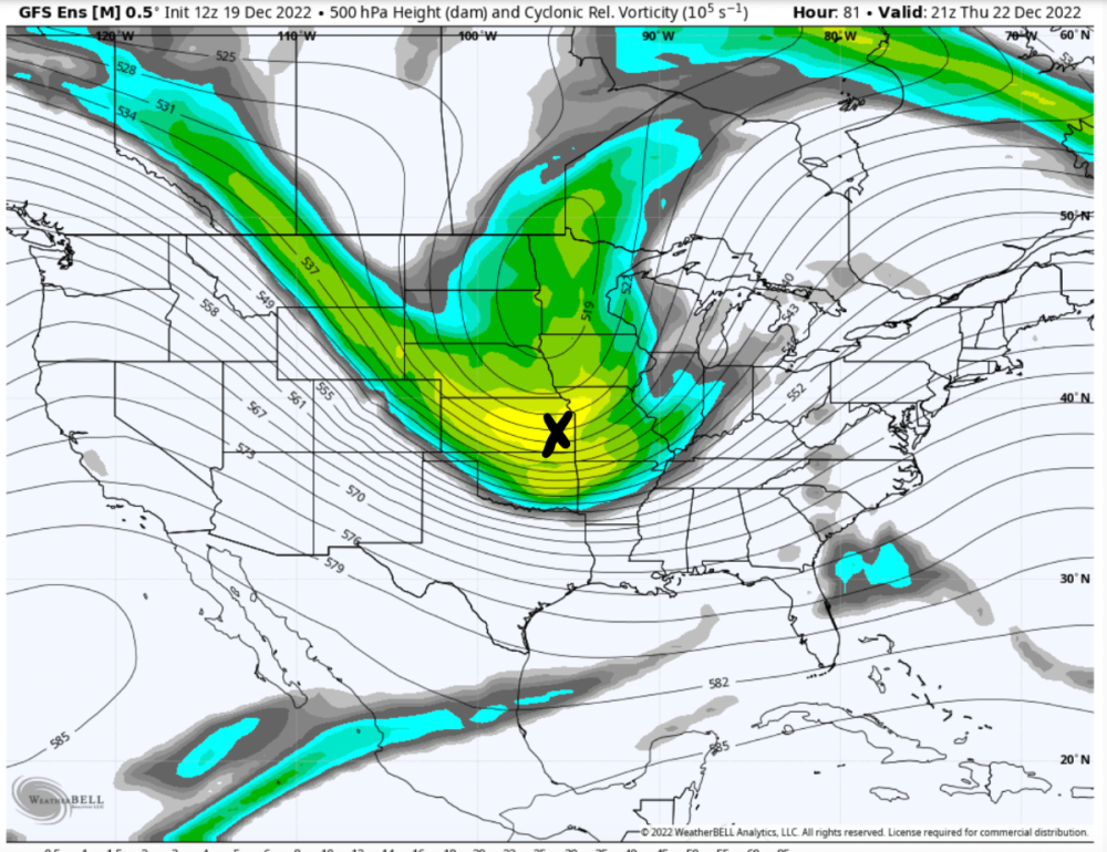

-
Pre-Christmas Storm Plains/MW/GL 12/21-12/22
Jack_GradStudent replied to bud2380's topic in East of the Rockies
Can only pray for a track like this.. wishing this was Wednesday night rather than Sunday night. GEFS also has continued to show this trough getting its act together much quicker and taking that negative tilt as it translates over Kansas and Missouri. Deterministic GFS spews out over an inch of liquid which is just not supported by any of the other data at this point whatsoever. An inch of qpf has got to be still considered a 95th percentile type of solution at this point. Storms like this that bring in tons of cold air in my experience often rack up snow totals not due to lots of qpf but higher ratios.. at best I see ~0.75 qpf from this storm but one that the ratios could kick snow totals up to a foot of snow or so.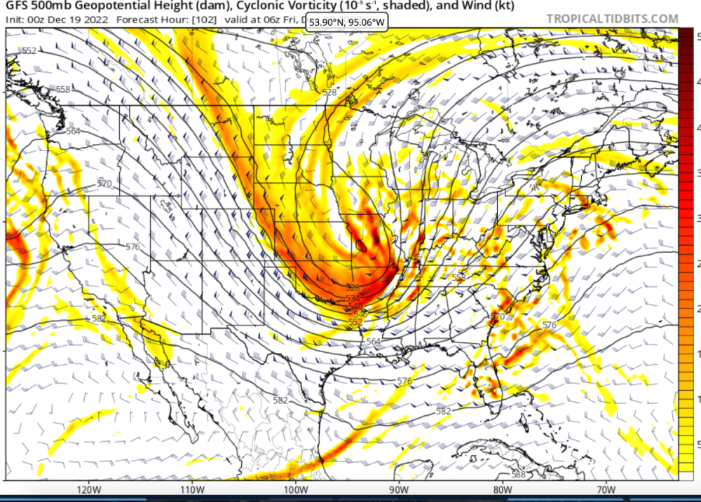
-
Pre-Christmas Storm Plains/MW/GL 12/21-12/22
Jack_GradStudent replied to bud2380's topic in East of the Rockies
https://whatgoesonoutside.com/a-wild-winter-weather-christmas-week/ My take on the potential impacts from this week's weather pattern... love sharing my thoughts on any hazardous weather via my blog and welcome any new followers! Join me on What Goes on Outside! Jack