


Andrew M
-
Posts
78 -
Joined
-
Last visited
Everything posted by Andrew M
-
November 2022 PNW weather Discussion. #NoRidgeNovember
Andrew M replied to Iceresistance's topic in West of the Rockies
Snowing moderately and sticking once again, 850 feet NW Portland. 32.7 degrees -
November 2022 PNW weather Discussion. #NoRidgeNovember
Andrew M replied to Iceresistance's topic in West of the Rockies
Lightly snowing and sticking here at 850 feet in NW Portland. Temp 32.2 -
February 2021 PacNW Weather Discussion
Andrew M replied to BLI snowman's topic in West of the Rockies
Has a fairly accurate record, usually very conservative and calls busts early on, but he is gung ho on this system for Portland. -
February 2021 PacNW Weather Discussion
Andrew M replied to BLI snowman's topic in West of the Rockies
Wow, major PDX snowstorm!! -
February 2021 PacNW Weather Discussion
Andrew M replied to BLI snowman's topic in West of the Rockies
00z Nam 2C colder Wednesday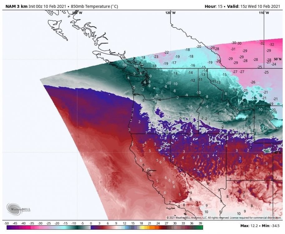
-
February 2021 PacNW Weather Discussion
Andrew M replied to BLI snowman's topic in West of the Rockies
Latest thoughts from Mark Nelsen for Thursday into Friday morning for Portland.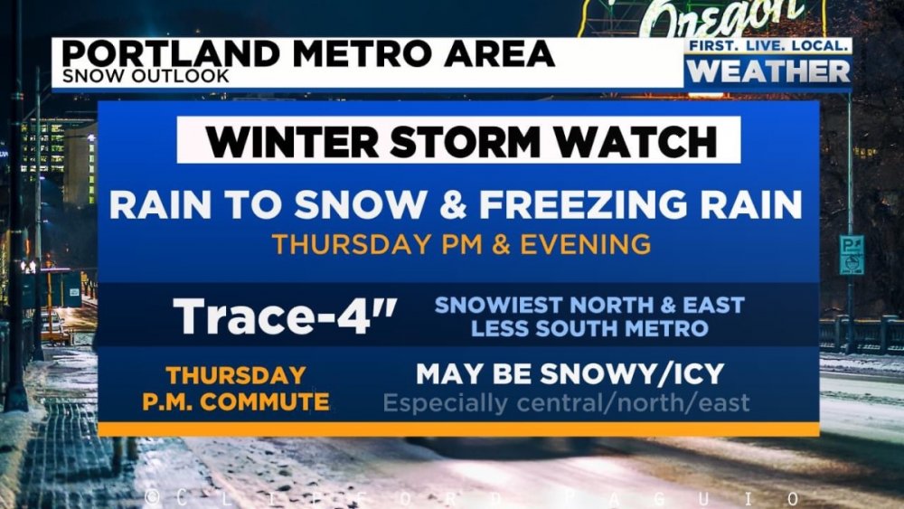
-
February 2021 PacNW Weather Discussion
Andrew M replied to BLI snowman's topic in West of the Rockies
Mark Nelsens latest thoughts for Portland, confidence increasing for major snow/ice event for the metro area. https://fb.watch/3yRGLfMvPz/ -
February 2021 PacNW Weather Discussion
Andrew M replied to BLI snowman's topic in West of the Rockies
Winter Storm Watch just issued for Portland area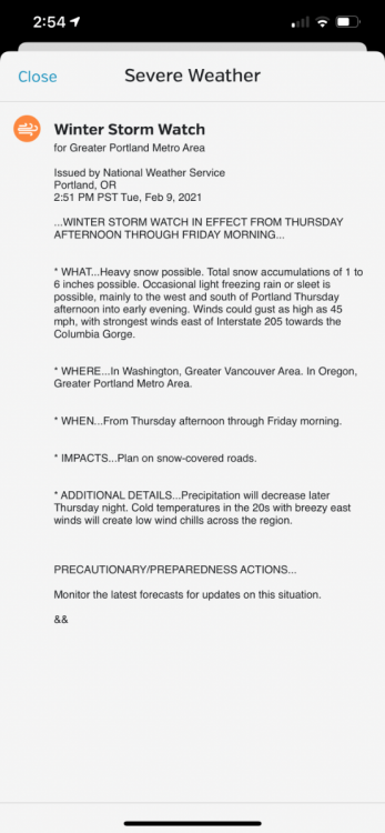
-
February 2021 PacNW Weather Discussion
Andrew M replied to BLI snowman's topic in West of the Rockies
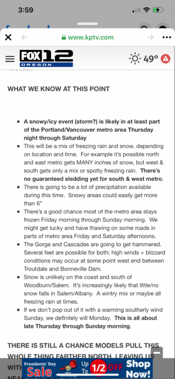
New update from Fox 12 for Portland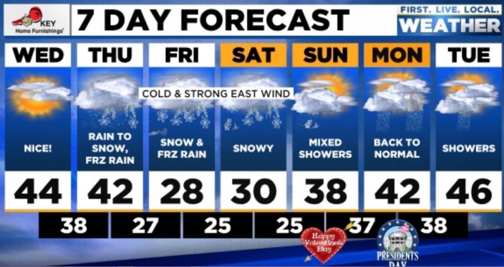
-
February 2021 PacNW Weather Discussion
Andrew M replied to BLI snowman's topic in West of the Rockies
I hear ya, been through these busts a million times, never gets easier. That said, i'm not sold on this being a bust yet. Even the bust models give us some snow and freezing rain. Slight adjust will make huge differences here. This could be the last shift north before some wobbles south tonight into tomorrow, seen that a million times too. Time will tell -
February 2021 PacNW Weather Discussion
Andrew M replied to BLI snowman's topic in West of the Rockies
1 Nam run and its storm canceled huh? -
February 2021 PacNW Weather Discussion
Andrew M replied to BLI snowman's topic in West of the Rockies
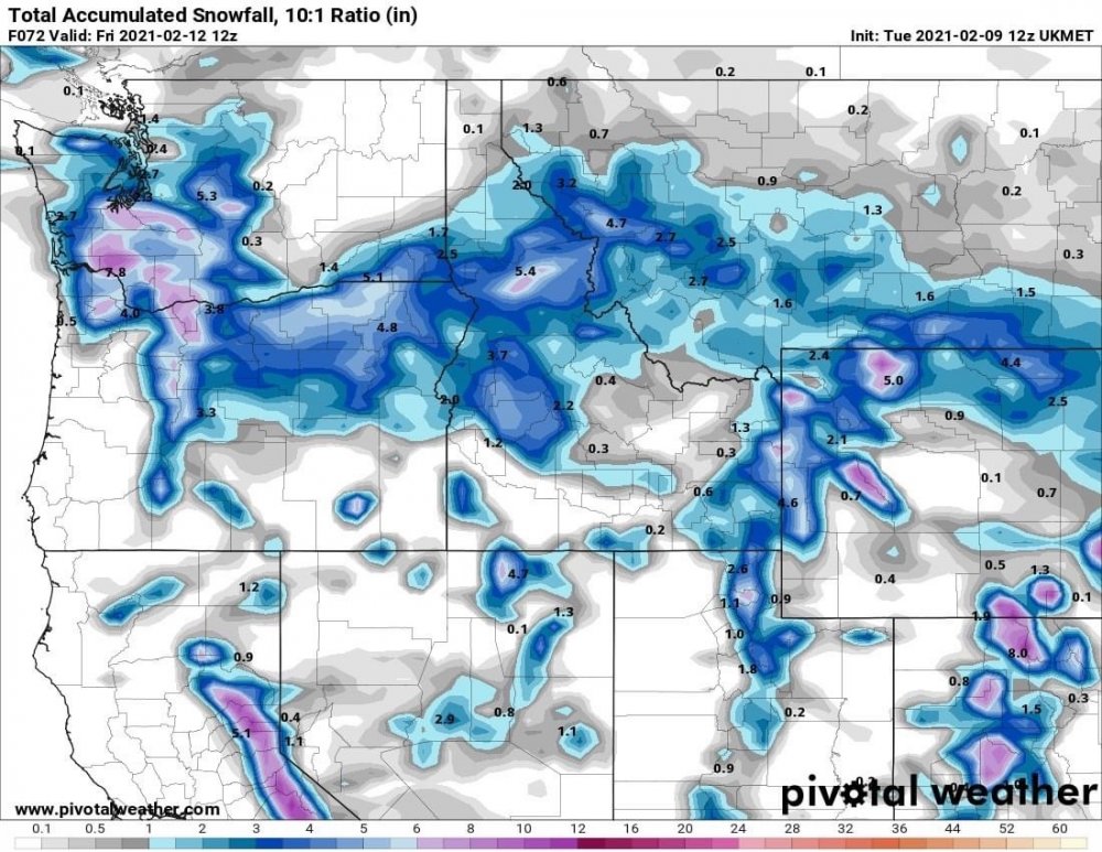
NBM gives PDX to Olympia 10-12 inches of snow -
February 2021 PacNW Weather Discussion
Andrew M replied to BLI snowman's topic in West of the Rockies

-
February 2021 PacNW Weather Discussion
Andrew M replied to BLI snowman's topic in West of the Rockies
UKMET is a Tillamook, Oregon landfall -
February 2021 PacNW Weather Discussion
Andrew M replied to BLI snowman's topic in West of the Rockies
This may end up being the final wobble north before a slight adjustment south based on the model means. Landfall appears increasingly likely somewhere between Tillamook and Astoria before heading ESE. -
February 2021 PacNW Weather Discussion
Andrew M replied to BLI snowman's topic in West of the Rockies
Op appears to be one of the most northern trends, mean is a between central and northern Oregon coast -
February 2021 PacNW Weather Discussion
Andrew M replied to BLI snowman's topic in West of the Rockies
GEFS low locations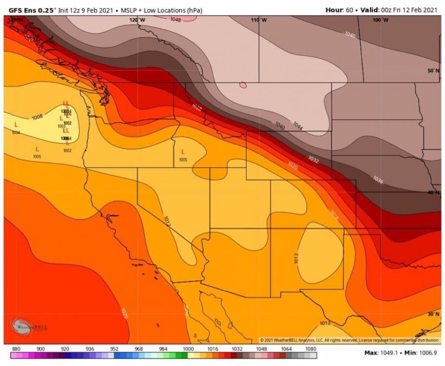
-
February 2021 PacNW Weather Discussion
Andrew M replied to BLI snowman's topic in West of the Rockies
Looking at temps around Bellingham and north it appears to be colder than the Euro forecast and more in line with the GFS so far. -
February 2021 PacNW Weather Discussion
Andrew M replied to BLI snowman's topic in West of the Rockies
Seems reasonable. I'm feeling somewhat comfortable here in the west hills of NW Portland, though further slight moves north could even effect here greatly. May still see another nudge south again though as the Euro and GFS come together over the next 24 hours. -
February 2021 PacNW Weather Discussion
Andrew M replied to BLI snowman's topic in West of the Rockies
Good point, could certainly be more of a ZR event with bursts of snow at times too. Who knows -
February 2021 PacNW Weather Discussion
Andrew M replied to BLI snowman's topic in West of the Rockies
Wants to have PDX start as snow Thursday morning, thinks the east winds will usher in colder air faster -
February 2021 PacNW Weather Discussion
Andrew M replied to BLI snowman's topic in West of the Rockies
6Z GFS Ensembles for Portland, WOW!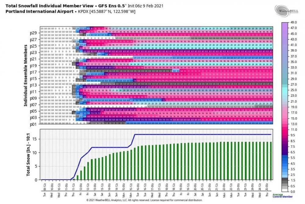
-
February 2021 PacNW Weather Discussion
Andrew M replied to BLI snowman's topic in West of the Rockies
Massive difference in low placement between the GFS and EURO, who caves to who? OR/WA border verse northern Cali. I predict one or the other makes a massive move between tonight and tomorrow morning. -
February 2021 PacNW Weather Discussion
Andrew M replied to BLI snowman's topic in West of the Rockies
Regardless of where the low placements ultimately ends up i think its important to remember that in these setups the northern edge of the precip shield can often extend much further north than modeled too. -
February 2021 PacNW Weather Discussion
Andrew M replied to BLI snowman's topic in West of the Rockies
Looks like the hills around town could be getting hammered for a couple hours as the cold slowly works its way down.


