


AquariusRadar
-
Posts
302 -
Joined
-
Last visited
-
Days Won
1
Everything posted by AquariusRadar
-
2022-2023 California and Southwest Weather Thread
AquariusRadar replied to Thunder98's topic in West of the Rockies
That Texas low made it to Chihuahua/Sonora and is now expected to enhance the summer monsoon in the Southwest More monsoon for Arizona and New Mexico. https://www.yahoo.com/news/tropical-boost-fuel-most-significant-121939190.html -
August 2022 Observation & Discussion
AquariusRadar replied to Timmy Supercell's topic in East of the Rockies
That Texas low continues along the predicted path right into the Pecos. No turning so far. Training thunderstorms right along the river are going to create some flash flooding. West Texas needs the rain but the tree-less hard pan soils make flash flooding a problem- like most of the dry Southwest. The Rio Grande onion farmers will like that extra water. -
August 2022 Observation & Discussion
AquariusRadar replied to Timmy Supercell's topic in East of the Rockies
The unnamed? Gulf coast system is ashore and giving south Texas good rain. The thing is headed Northwest into the heart of Texas which will be good. When it will turn to the Northeast will determine if it interacts with the cold front. Good for drought areas but maybe bad for Ky and the Ohio valley if it hangs together that long. -
2022-2023 California and Southwest Weather Thread
AquariusRadar replied to Thunder98's topic in West of the Rockies
I have to disagree with Daniel Swain Weatherwest on this one. Daniel's study must be based on something other than recent weather history. The article here Epic Flooding for California future. How can the scientists say epic flooding ahead along with predictions of long term drought? Yes big ARs are always possible but unlikely to create historical flooding. https://www.yahoo.com/news/disaster-larger-world-history-coming-204541985.html -
Louisiana Cypress Hammock
AquariusRadar posted a topic in Climate, World Weather, and Earth Sciences
Louisiana is losing hundreds of acres annually to coastal erosion due to lack of river deposits, storms, and slow sea level rise. Flood control efforts from decades ago have slowed the deposits of mud and gravel such that the creeping sea level rise has overcome the rate of mud deposition. Efforts are underway to return the flood deposits. Even if successful the natural deposition is being overwhelmed by slow but continuous sea level rise. One of the possible solutions to stop the loss of land is the development of cypress hammocks along all the fresh water and near the brackish bodies of water in south Louisiana. The bald cypress establishes massive root systems that binds the river flood deposits creating natural levees along rivers and streams and hammocks in areas away from the flowing water but subject to flooding. These root systems and associated knees may constitute up to 50% of the soil volume. The bald cypress tolerates brackish water and periodic flooding by sea water as long as the flooding is short duration. The tree is long lived and capable of withstanding the hurricanes that frequent the area. The tree enjoys a positive ph environment and rapid growth when the ph is greater than 7.2. Hammocks and levees may require periodic liming to keep the ph up. Composting leaf litter and vegetation of the delta environment creates acid conditions which must be countered with liming. In communities on the water front, additional living space can be made by supplemental sand and gravel emplacement around the knees of the more mature trees. The knees continue to grow vertically until well above the extreme flood level. The knee growth can cause infrastructure problems for water and sewer pipes, but because most communities are built several feet above water level, long term problems are remedied by cutting the top off the knee. Cutting straight across the knee does not harm the tree as long as the root system that interconnects the numerous knees is nor severed. Roads would have to be elevated well above the flood level to prevent the knees from forcing up the road pavement. This cypress barrier would stop the loss of land in southern Louisiana and acts to store excess carbon. A cypress tree may grow for 100 years, stand as a mature tree for another 100 years. spend another 100 years in decline , stand as a rot proof snag for another 100 years, and finally fall in the oxygen free mud where the log will be preserved for another 100 years. Cypress lumber is highly valued. -
Frazier River aqueduct
AquariusRadar replied to AquariusRadar's topic in Climate, World Weather, and Earth Sciences
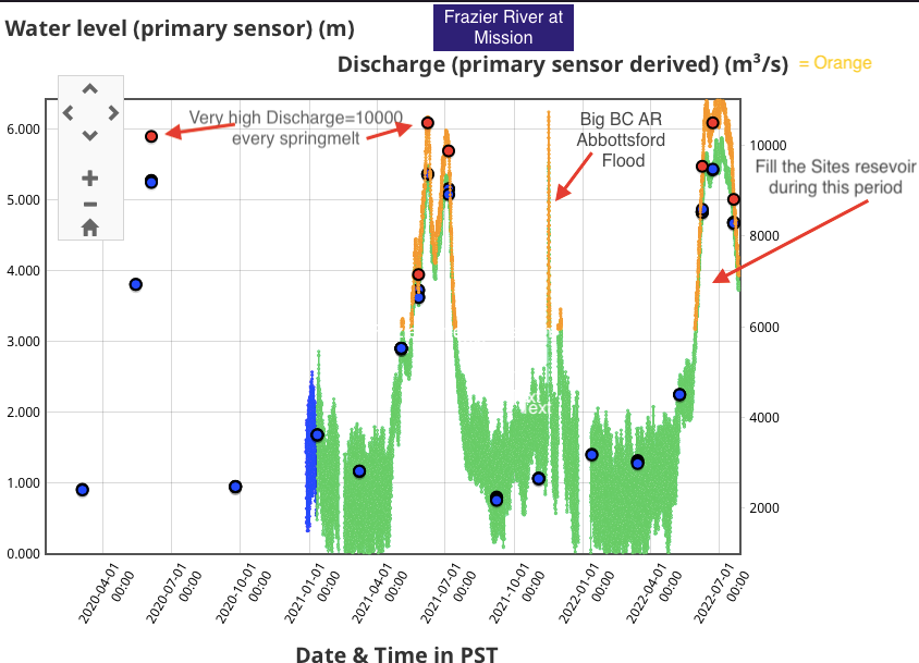
Rubis- thanks for that correction. Well I don't know if there are any economic studies that show competitive benchmarks for desalinization vs aqueduct. Would they be meaningful if there were? Both are extremely expensive. A tossup but why would that immediately disqualify an aqueduct? Yeah and Canada does sell the US lots of lumber, oil, hydroelectric power and a whole host of natural resources and manufactured products. Why would they not want to sell flood water? What's so precious about flood water? California can deny the continuing drought- as many want to do. There are many examples of trouble ahead-example: Monterey, Mexico put off building aqueducts to rivers further south and now suffers no- that's a no- zero-running water for the majority of the 5 million people who live there. Phoenix and Las Angeles are just a few years away from similar circumstance. The Colorado river is not going to recover as a reliable water provider for LA and the desert southwest. So we can start digging now or die of thirst later on. The "Fraser" river flood will continue as a reliable source for the foreseeable future. We sent man to the moon and so we can build aqueducts-expensive but not rocket science. -
California aqueduct pipe flow at the Edmonton pumps is 450 cubic meters each second (33000+ gallons/sec) over the Tehacthape and down to SoCal. 450m cubed /second. The peak flow of the Frazier river in spring melt -late june early July -is 10,000 cubic meters per second. An aqueduct that took 10% of Frazier peak flow (1000 cubic meters a second) and routed it to the top of the Sacramento would be twice the California State Water flow over the Tehacthape. During the short period of maximum flow- perhaps an average of 45 days - the storage lakes of California could be charged. The soon to be new Sites reservoir could be filled annually. Considering the high cost of water for California, Canada would like to sell water to California. Once the water starts flowing the price will drop and make aqueduct costs competitive with desalinaztion. Pumped hydro storage will be used to make operation more efficient. The Frazer river is the only alternate to Columbia river water and is studied only because the folks in the Columbia basin are absolutely adamant about not selling to California. Strange isn’t it how far apart Americans really are.
-
2022-2023 California and Southwest Weather Thread
AquariusRadar replied to Thunder98's topic in West of the Rockies
If these La Nina conditions persist- Would in make sense to invest now in an aqueduct. Water for the West costs a lot of money and folks with an excess of water will sell it at the right price. Nasdaq quote for water (California delivery) is currently $1000 + per acre foot. That price will drop radically if and when water begins to flow. Canada may be willing to sell Frazier river flood water for that price. Looks as if the Frazier will remain with a water excess. The federal aqueduct pathway is straight down I- 5 to the Klamath? and top of the Sacramento. -
This cluster of thunderstorms over northern Sonora illustrates that monsoon moisture could be a major source of SoCal rain. Extreme southern Arizona got 1-2 inches from this storm with isolated 3 inch radar reports. California weather scientists should be investigating methods to move more monsoon rain to SoCal using geo-engineering (weather modification). Drought stricken Northern Mexico would not object.

-
I had hoped a moderator would reply here on the complaint thread. But since you Mr. ML are everywhere and apparently in charge of handling complaints-Don't worry, I won't read any- I know in advance the ideas of the political posts..
-
A politics thread should not be permitted on this forum. Political posts sully the entire atmosphere (no pun intended) of the weatherforum. I regret opening the thread and reading some of the posts.
-
Storm Blas has dissipated and TS Celia takes it's place. The monsoon moisture moves north and SoCal got some beneficial rain 22June. TS Blas contributed to the monsoon moisture flow that created the showers. The summer monsoon must be considered as a possible alternate for meaningful rain to the normal winter rains of California. The winter rain/snow have been hit or miss for the last several decades. Those rains are dependent upon crossing up and over the blocking high. Like a black hole for moisture, the ridge has produced drought for California, Colorado Plateau, and the West in general. Blas died at just the right place and moment to add to the northerly movement of monsoon moisture. The Pacific part of that moisture avoids the southern circulation of the Pacific high and surges up the west coast of Mexico into the low pressure area created by the desert summertime. Aquariusradar can enrich this flow of moisture by targeting thunderstorms in storms like Blas and Celia. Those individual thunderstorms are inhibited and not allowed to complete the normal course of growth and decay. With moisture driven to high altitude, the targeted CN cell is not allowed to reach maturity and moisture remains aloft to follow the northward flow of the monsoon winds. Aquariusradar would operate from ships at sea.

-
The summer monsoon for the desert SW is underway. Tropical storm Blas is moving WNW; now just south of the Baja and predicted to die as a remnant low. The lightning strikes mark the thunderstorm activity- mostly on the north side of the storm circulation. Aquariusradar, operating on the south side of the storm, would temper thunderstorms there and provide more moisture for those storms on the north side of the storm. Constantly inhibiting individual thunderstorms on the south side of the circulation, and consequently encouraging thunderstorms on the northern half, would help steer the storm center on a more northerly path and eventually bring more moisture to SoCal and Arizona
-
2022-2023 California and Southwest Weather Thread
AquariusRadar replied to Thunder98's topic in West of the Rockies
Today is last Friday of April-Arbor Day. Plant a tree. The water cycle will not work without trees. -
2022-2023 California and Southwest Weather Thread
AquariusRadar replied to Thunder98's topic in West of the Rockies
Bowling ball low hit a strike for the NorCal and central coast. Eelriver had 1.82 inch last 24hr. High Sierras good had 5.43 inch Donner Pass dam. A helpful rain event. Next time a little further south please. Correction..... Mr. ML is right- the 5.43 is an unverified snow report and does not show up when looking at QC'd verified reports. So maybe .54 inches of water which is near all others in that area. -
It's Friday 1:30 pm and the start of a quiet weather weekend for SOCAL. But off the central coast just south of Eureka, bright yellow blobs among the greens of the radar reflectivity lie just offshore and move towards the east as a small cyclone approaches from the west. This heavier precipitation from the CN showers falls to the sea. If aquariusradar was at work, either ashore or on a ship just offshore, tempering those more active CN cells raining on the ocean surface, the inhibited showers would provide abundant moisture for showers moving up and over the coast mountains. Less rain on the ocean and more rain on the land. A large portion of that extra rain could be impounded by local reservoirs. SOCAL needs water and every opportunity to transport rain ashore from the ocean storms must be taken. Mother nature lifts the water to great height, aquariusradar inhibits the water coming down, and orographic storms ashore then use that extra moisture for more rain ashore.
-
2022-2023 California and Southwest Weather Thread
AquariusRadar replied to Thunder98's topic in West of the Rockies
In addition to the current little bowling ball low headed for the north coast, as described by Dan Swain at weatherwest, more and better rain expected 21-23 April. North of Monterey he says. Maybe today/tonight's little low will prove more than a whimp. Moving southeast so maybe some of the SOCAL will get a drop. -
2022-2023 California and Southwest Weather Thread
AquariusRadar replied to Thunder98's topic in West of the Rockies
Lotsa moisture streaming over the coast. Moderate Rain for North/ Central Cal Friday afternoon through Saturday predicted. When ya need a strong beefy low- all we get is a whimp of a circulation. -
2022-2023 California and Southwest Weather Thread
AquariusRadar replied to Thunder98's topic in West of the Rockies
The low pressure center is just now crossing over the central Oregon coastline; the associated trough pushes down towards Sacramento. Light showers along the north coast and in the Sierras. Hopefully the low center will sink due south and give the central coast a little rain. -
April 2022 (April 2008/2011 redux)
AquariusRadar replied to TacomaWaWx's topic in West of the Rockies
Keep the White background. It helps highlight most of the color images posted. Keep black text on white. -
2022-2023 California and Southwest Weather Thread
AquariusRadar replied to Thunder98's topic in West of the Rockies
Forecast for opening day April 13...Dodger stadium ..the batter ready and pitcher winds up...it's an inside slider with about an inch up north but dry here at the stadium a swing and a miss. This may be the last chance this season. -
2022-2023 California and Southwest Weather Thread
AquariusRadar replied to Thunder98's topic in West of the Rockies
I wonder if the heat will/has hurt the Poppy bloom in Antelope Valley? Goodbye March miracle -maybe April showers will bring May flowers. Still a chance for rain. -
2022-2023 California and Southwest Weather Thread
AquariusRadar replied to Thunder98's topic in West of the Rockies
A fish scale or mackerel sky from Thunder98 previous post. Says the olde farmers almanac- " like scales on a mackerel. Mares’ tails describe thin and wispy cirrus clouds, which are indicative of strong high-level winds. These types of clouds are influenced by shifting wind directions and high speeds, typical of an advancing low-pressure system."
-
2022-2023 California and Southwest Weather Thread
AquariusRadar replied to Thunder98's topic in West of the Rockies
The upper dry air index remains low (wet). Reminiscent of the first half of 2021-2022 winter. More rain if the cyclones come our way.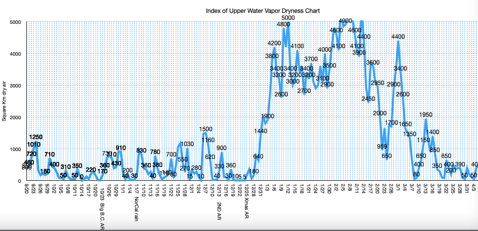
-
2022-2023 California and Southwest Weather Thread
AquariusRadar replied to Thunder98's topic in West of the Rockies
The ITCZ remains active and the upper water vapor is wet. If the next low trough will get down south, we could expect some more rain.


