


hlcater
-
Posts
2123 -
Joined
-
Last visited
-
Days Won
2
Everything posted by hlcater
-
Yea that’s weird. Thanks for pointing it out, I wouldn’t have noticed
-

12/27 - 12/29 Upper MW/GL's Multi-System Snow Event
hlcater replied to Tom's topic in East of the Rockies
Tomorrow is pretty interesting. Arguably more interested in that system than today's even if snowfall totals are somewhat lesser. Light and high ratio snow on top of today's 3" of slush will really make it look like winter around here. -
Sleet in Iowa City already. Interesting.
-
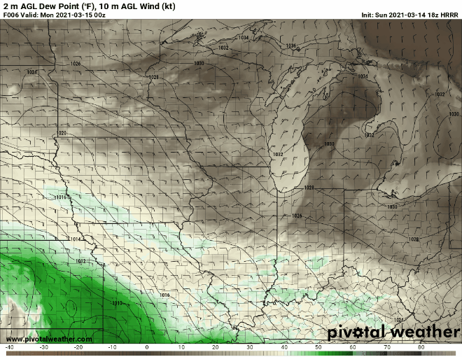
HRRR going off
-
There's this super subtle detail on the HRRR that I think is likely responsible for the heavier snow further south. On the 18z run, there's a patch of really quite dry surface dewpoints in the mid to upper teens that gets advected in later tonight. As this area of lower dews gets moistened, it increases the effects of evap cooling and leads to an overall cooler column than other models at the same time ---> heavier snow further south. It's more evident on skew Ts but I cant gif those
-
Tough forecast for the area. Gonna stick with ~2" in Iowa City, but that could easily be much higher or nothing at all depending on the speed at which evap cooling can work.
-
Yea this is gonna be an interesting one. I like potential for TSSN(due to some fairly steep lapse rates aloft and very strong FGEN) in that band especially as modeled in the more aggressive guidance. Could be a very quick hitting 6+ for someone. Should also note that this system is favorably timed overnight so shouldn't have sun angle problems.
-
Today's snowfall has pushed me over 50" for the season!
-
Rime City on this leading edge. Been acting like we’re saturating from the bottom up instead of the top down by starting as mixed precip even though column temps are cold.
-
Expecting 2-3” in IC today.
-
Valentines and Presidents Day Oklahoma and Mid West Smasher.
hlcater replied to Clinton's topic in East of the Rockies
Pure pixie dust ^^ Might see an inch if it continues all night as CAMs suggest it will. -
The storm to close out January really dried up on the models, so that's not entirely true.
-
Sundogs and light pillars this evening from a friend in waterloo.
-
Gonna say we have about 4" in IC. Family measured 5" in Hiawatha. Not gonna attempt to be any more precise than that.
-
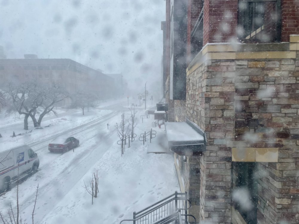
It's my own screenshot.
-
Blizzard criteria officially met at CID.
-
My thoughts exactly. Not only that, it appeared as if there was no sync between the morning package and afternoon package. Ervin and Speck in the mornings consistently gave the storm more respect than the afternoon staff did.
-
One of DVN’s worst busts recently that’s for sure. Holding the blizzard warning and way under forecasting amounts. They looked clueless. CR/IC on pace to meet the criteria easily.
-
The stuff that’s falling now is really dry and just adding fuel to the fire. Probably 14-15:1 stuff. Meanwhile our first inch was no more than 8:1. Tale of two storms here.
-
Backside of the snow is still a few hours away by the looks of it, so may tack on 0.5-1" yet.
-
Not even going to attempt to measure, but my guess is that we're close to 4" now.
-
-
Visibility in IC is probably 1/8th of a mile. Can’t even see 2 blocks away. Phone pic out the window.
-
Front just passed.
-
Back to moderate snow. Front is just to my west on wundermaps. Expecting the heavy band a county or two behind the front to have blizzard conditions.


