Bodhijr
-
Posts
31 -
Joined
-
Last visited
Bodhijr's Achievements
")


-
Extremely happy for the chance of precip coming, especially living only 10 miles outside of Medical lake WA. It got wild down here.


-
 Bodhijr changed their profile photo
 -
February 2019 Weather Observations and Discussion Part 2
Bodhijr replied to snow_wizard's topic in West of the Rockies
That's very impressive, I agree that we will most likely make it beyond the 30 days without a sunspot. But Just watch, there will be a huge coronal hole covering half the Sun in 2 weeks screwing things all up. Lol -
February 2019 Weather Observations and Discussion Part 2
Bodhijr replied to snow_wizard's topic in West of the Rockies
LOL, I assume that's a first. -
February 2019 Weather Observations and Discussion Part 2
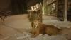
Bodhijr replied to snow_wizard's topic in West of the Rockies
It's been so long since we have had good snow I just had to share. Pee Dragon!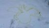
-
February 2019 Weather Observations and Discussion Part 2
Bodhijr replied to snow_wizard's topic in West of the Rockies
This guy has a lot of info about the Sun. Ben davidson https://www.youtube.com/user/Suspicious0bservers Very Smart dude! -
February 2019 Weather Observations and Discussion Part 2
Bodhijr replied to snow_wizard's topic in West of the Rockies
Good Lord! You could start your own Wim Hof training camp in that! -
February 2019 Weather Observations and Discussion Part 2
Bodhijr replied to snow_wizard's topic in West of the Rockies
Nice! Great times, And Justice for All and some Breadfan! -
February 2019 Weather Observations and Discussion Part 2
Bodhijr replied to snow_wizard's topic in West of the Rockies
I was also 16 during that time, learning how to bridge my amplifier in my 1971 Ranchero so I could blast my Pantera for all to hear! -
February 2019 Weather Observations and Discussion Part 2
Bodhijr replied to snow_wizard's topic in West of the Rockies
Is this distance based on the flat earth measurement or the metric system? -
February 2019 Weather Observations and Discussion Part 2
Bodhijr replied to snow_wizard's topic in West of the Rockies
Almost had all my grass back. This is at 1000' in East Washougal. I truly wasn't expecting perfect powder with a light east wind. If this keeps up I'll have to change out my foot thongs for something more insulated.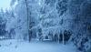
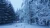
-
January 2019 Weather in the Pacific Northwest
Bodhijr replied to Requiem's topic in West of the Rockies
-
January 2019 Weather in the Pacific Northwest
Bodhijr replied to Requiem's topic in West of the Rockies
Just ran 1" pex from a new well to my house. Its still in a open ditch 2 feet deep, I wasn't going to insulate it this week but maybe i should. Looking a bit nippy in Skamania county soon! -
4" in Washougal 550'elevation so far. A ton of cars caught off guard. They didn't make it up the hills out here, it looks like armageddon with various vehicles in the ditches. With the east wind out here is a out right BLIZZARD! Love It!
-
Light snow starting in Washougal down by the Columbia River.
-
For the Clark County people... Stay thirsty my friends! ** MORE SNOW THIS WEEK ** Updated: 11:00 AM Monday The National Weather Service has issued a Winter Weather Advisory for light snow late tonight across Clark County and Southwest Washington, as another cold system arrives tonight. This system has the potential to bring snow down to sea level late this evening under heavier showers. Most of the heavier accumulation should stay just above the valley floor. But all areas could see some snowfall. All eyes then turn to Tuesday night and Wednesday. It now appears as though a more significant system will arrive off of the Pacific Tuesday night into Wednesday morning. The exact track of this storm will be critical to how much snow will fall across the Portland metro area. At the present time, models are taking the center of the storm just to the south of Portland. As this happens, cold east winds will return reinforcing the cold air at the surface. Models continue to vary on the amount of snow forecast. But the Tuesday night system has the potential to be an area-wide snow event with little to no freezing rain. It also has the potential to be the most significant snow event we have seen this winter in terms of accumulation in the Portland metro area. It could cause quite a mess for the Wednesday morning commute. Details are still coming into focus with each new model run. Reinforcing modified arctic air then returns for the second half of the week under clearing skies and overnight temperatures dropping below freezing once again. The KOIN 6 weather team is tracking this week's snow potential and we'll have the latest updates on air and online 24/7. Steve Pierce KOIN 6 Meteorologist