Nelson
-
Posts
13 -
Joined
-
Last visited
Nelson's Achievements
")


-
2/24-2/26 Snow (Ring the doorbell so the big dog wakes up!!!)
Nelson replied to Madtown's topic in East of the Rockies
-
2/24-2/26 Snow (Ring the doorbell so the big dog wakes up!!!)
Nelson replied to Madtown's topic in East of the Rockies
Looks pretty similar to yesterdays 12z run to me.... -
-
Received 3.1" here overnight. Anything hit by the sun has melted but anything in full shade is sticky around - for the moment. Expected to get close to 40F tomorrow so I suspect most of it will be gone by tomorrow.
-
January 2019 Observations and Discussion
Nelson replied to Minny_Weather's topic in East of the Rockies
http://mp1.met.psu.edu/~fxg1/ECMWF0.5_0z/f120.gif -
January 2019 Observations and Discussion
Nelson replied to Minny_Weather's topic in East of the Rockies
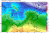
I don't think this needs explanation. This is a favorable look for 5 days out. http://mp1.met.psu.edu/~fxg1/ECMWF0.5_12z/f144.gif -
Jan 18th-20th Potential Winter Storm. Can this be The One??
Nelson replied to jaster220's topic in East of the Rockies
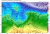
Might be talking about the wrong storm....... http://mp1.met.psu.edu/~fxg1/ECMWF0.5_12z/f216.gif -
January 2019 Observations and Discussion
Nelson replied to Minny_Weather's topic in East of the Rockies
The ridge out west has been prominent for several years now. Like you said, it will break down from time to time, but seems like it's going to be there until we get a major shift in the pattern. -
Dry slot just about to hit here. Pure rippage for 2-3 hours - best of the season by far. I'd say we are around 3-4" just by looking outside.
-
Also good consistency between Euro and GFS for the 2/21ish timeframe. Let's see how long that holds up.
-
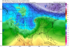
Don't mind taking my chances with this look. Could be rain but could be big snow... http://mp1.met.psu.edu/~fxg1/CMCNA_12z/test8.gif
-
Yep, definitely has a favorable look to it. Let's keep that ridge off the west coast... http://mp1.met.psu.edu/~fxg1/CMCNA_0z/test8.gif
-
EPS continues to drift ever so slightly south. Obviously rooting for that for MBY so take that with a grain of salt. Still, an interesting data point.