WeatherCrossing
-
Posts
25 -
Joined
-
Last visited
Everything posted by WeatherCrossing
-
Valentine's Day/President's Day Snow System and 16th Clipper
WeatherCrossing replied to Tom's topic in East of the Rockies
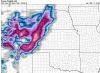
Very strong winds develop just offshore Maine/Massachusetts as this system pulls north. The NWS has a high wind warning out for the Boston area with 20-30 mph sustained and 55 mph gusts. Attached is the latest HRRR 10 m winds. http://i.imgur.com/eoApSgJ.png -
Valentine's Day/President's Day Snow System and 16th Clipper
WeatherCrossing replied to Tom's topic in East of the Rockies
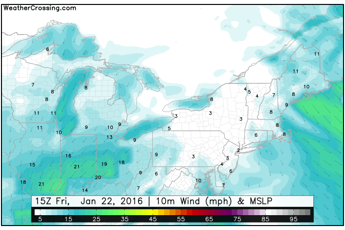
As this system pulls north, it is going to bring plenty of warm air and rapidly intensity. Sustained winds near 50 mph are forecast for the Atlantic. From our 4 panel model viewer... http://i.imgur.com/yyqDM7r.gif -
Valentine's Day/President's Day Snow System and 16th Clipper
WeatherCrossing replied to Tom's topic in East of the Rockies
Hi Geos, thank you, we appreciate it. You can find our graphics at http://www.weathercrossing.com. Though you may have been asking our physical location...We are in Sacramento CA. -
Valentine's Day/President's Day Snow System and 16th Clipper
WeatherCrossing replied to Tom's topic in East of the Rockies
I realize this don't go to the end of the system...but the WRF models (NMM & ARW bottom panels) have the rain/snow line much further north. Total Snow: NAM (top left), 4km NAM (top right), ARW (bottom left), NMM (bottom right) http://i.imgur.com/YC2HAks.png -
Valentine's Day/President's Day Snow System and 16th Clipper
WeatherCrossing replied to Tom's topic in East of the Rockies
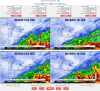
Good consistency between NAM runs. 12Z vs 00Z total snow. 18Z looks very similar. http://i.imgur.com/UP0DOY8.png -
Ground Hog Day Blizzard/Snowstorm Part II
WeatherCrossing replied to Geos's topic in East of the Rockies
And so it begins... http://i.imgur.com/pbkgy5l.gif -
GHD III Winter Storm Possibility, Feb. 1st-3rd
WeatherCrossing replied to Geos's topic in East of the Rockies
As this low moves eastward the gradients really tighten up. 10 m sustained winds will meet or exceed 25 mph with extremely heavy snow. http://i.imgur.com/4mABsIu.gif -
GHD III Winter Storm Possibility, Feb. 1st-3rd
WeatherCrossing replied to Geos's topic in East of the Rockies
A look at the snowfall in/around Denver, CO shows 6-9 inches. The NMM is a complete outlier! Any thoughts? Is this typical of this area? http://i.imgur.com/348tmh1.png -
GHD III Winter Storm Possibility, Feb. 1st-3rd
WeatherCrossing replied to Geos's topic in East of the Rockies
Latest snowfall totals from our 4-pannel viewer (GFS left, NAM right). Tracks are in much better agreement now.
-
GHD III Winter Storm Possibility, Feb. 1st-3rd
WeatherCrossing replied to Geos's topic in East of the Rockies
Here are the latest GFS and NAM tracks....there are still some large differences.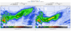
-
There is a real threat to the East Coast for this upcoming storm. The GFS has been fairly consistent with the general precipitation totals. Additionally, the 13km GFS output (18Z) shows 40+ mph 10 m winds well inland in New Jersey. 50+ mph along the coast!
-
The active weather patten shows now sign of letting up! Rainfall for the next 10 days (GFS 20150115 00Z run).

- 4298 replies
-
- 4
-

-
- Oregon
- Washington
- (and 1 more)
-
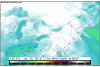
Over these next 10 days the Jan. 01 12Z GFS brings in at least 7 storms to the Pacific Northwest. Sunday night-Tuesday morning looks particularly heavy for northern California. 850mb temps will be around 5C in this area so this will be quite a warm system! http://weathercrossing.com/forumposts/20160112/156_precip3_centralwest.png http://weathercrossing.com/forumposts/20160112/156_temps_850_centralwest.png