FV-Mike
-
Posts
633 -
Joined
-
Last visited
Everything posted by FV-Mike
-
little over an inch of rain last night with the heavy storms. Lots of lightning
-
Flakes are flying. Grass is covered. NE wind. Nice to see winter again. Even if it is for a short time
-
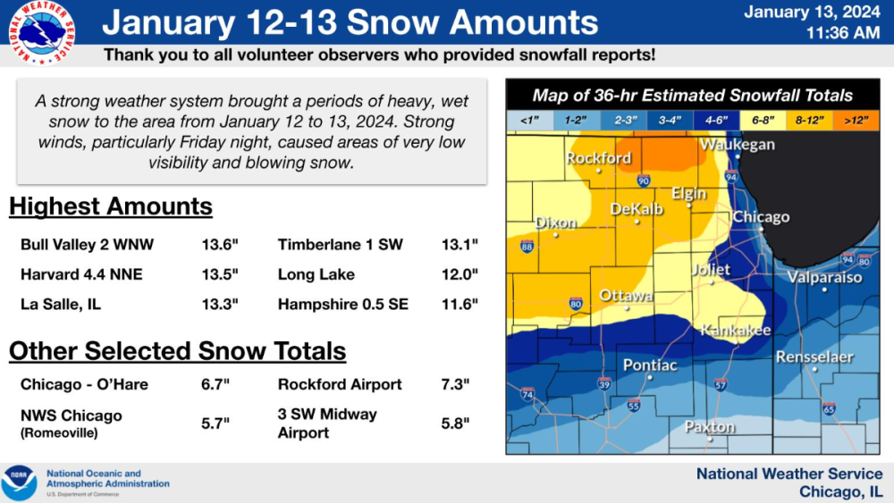
Final totals in Chicago area. O'hare almost to 7
-
It has been a while since we had 13- 14 inches on the ground. I know the closer you get to the lake the less but in an El nino year this has been a good week
-
Yep did alright. Finished with 7 . West and north burbs did well
-
All snow now in Kane county
-
Had 30 mins of sleet mix. I am back to all snow
-
already at 4 inches. CHI into Wisconsin should do very well today
-
my Grid for Geneva shows 7-15. ORD even has 6-13
-
Could someone post the 18Z GFS for points further East. Thanks!
-
I think uiowa needs to cancel the men’s bball game tomorrow
-
LOT sticking with global models. The forecast for this storm system continues to be handled best by the more consistent global forecast models and ensembles (especially the ECMWF and its ensemble members). We therefore continue to steer the forecast in this direction. Currently, many of the higher resolution models such as the HRRR, NAM and RAP continue to be northern and warm outliers with the system, and thus, their current iterations are not favored. Anyone have a good memory of the 12/15/87 that they are comparing this too? confidence continues to increase that this anomalously strong storm system (which bears a striking similarity to the heart attack snowstorm of Dec 15, 1987) will produce major impacts across much of northern IL into Saturday morning.
-
yep very interesting. Extended south through I80 even down to Kankakee
-
Got to think LOT will issue WSW this afternoon.
-
LOT AFD Uncertainty has increased with the next winter storm to impact the area Friday into Saturday. Specifically, the operational runs of many of the models have shifted northwest with the track of the low and bring a considerable amount of rain into at least the southeast third of the cwa, with the potential for a mix possibly even into the southern Chicago Metro area. Interestingly, it appears that the GFS and ECMWF operational runs are the farthest northwest of just about all of their respective ensembles, suggesting there is more support for a more southeastern track of the low then the operational runs show. They note the NW trend but caution it may be too far
-
Heavy snow in the western burbs. Just today makes up for the lackluster season last year
-
Heaviest snow coming down atm. huge flakes
-
Lake, Kane and LaSalle counties now upgraded to WSW for the CHI area
-
Flying back to Chi from Florida on 1/8. Glad my Flight is early on Monday and not Tuesday!
-
January 2024 Observations and Discussion
FV-Mike replied to Minny_Weather's topic in East of the Rockies
LOT AFD: Looking out beyond day 7, for multiple model cycles in a row, the ensemble means have consistently depicted the ejection of an anomalously deep western trough into the Midwest. The pieces could thus come together to support a strong synoptic system affecting the region (irrespective of precip. types) early in the first full work week of January. Medium-long range ensemble guidance also has been consistent in an active and colder pattern continuing through mid January, so there may eventually be some bonafide winter weather threats to track. Stay tuned. -
January 2024 Observations and Discussion
FV-Mike replied to Minny_Weather's topic in East of the Rockies
Long Range is looking better. I am just excited for the snow showers this Sunday! -
DECEMBER 2023 Observations and Discussion
FV-Mike replied to Grizzcoat's topic in East of the Rockies
Like the wording from LOT expectations are for a widespread precip event across a vast majority of the forecast area Thursday night and Friday morning. Precip type will be rain south of a Chicago to Mendota line, with increasing chances for a transition to all snow from north of Dixon to McHenry County. Where the cutoff in the precip shield settles is a looming big question that will have implications with how much (if any) accumulating snow occurs into the northwest third of the CWA. Given the increasing signal in guidance (especially EPS and CMCens) for accumulating snow and the factors noted above, have increased snow probs with some minor accumulations (<1") in the forecast late Thursday night into Friday morning. While still a lower (~20%) chance exists for several inches of accumulating snow in the aforementioned area, this solution is no longer an outlier within the broader ensemble of guidance. This is especially the case if the low-level baroclinic zones further contracts and supports a band of f-gen in a dynamically cooled thermal profile. -
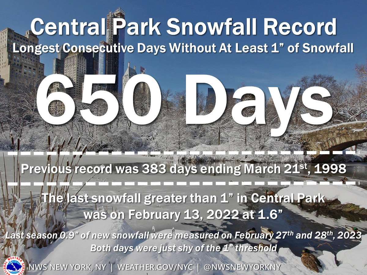
Fascinating post by NYC's forecast office.

-
11/25 - 11/27 CO/LOW Central Plains Snow and LES
FV-Mike replied to Clinton's topic in East of the Rockies
light snow falling. All roads and grass covered. no better way to kick off the season than a Sunday morning snowfall -
Radar looks great for SE Iowa!