St Paul Storm
-
Posts
3648 -
Joined
-
Last visited
-
Days Won
18
Everything posted by St Paul Storm
-
Haven’t stepped outside yet but eyeballing it I’d say we got about 5” of snow overnight. So what was supposed to be mostly rain/mix turned into a snowblower event. MPX: Overnight was a classic example of squeezing every ounce of energy out of the atmosphere over the Twin Cities as an intense mesoscale band of snow developed in response to a band of fgen centered in the h85-h7 layer. While most of you were sleeping, we saw snow rates of 2" per hour develop with this band, which quickly blanketed much of the metro in 3-5 inches of snow over the course of about 2-2.5 hours.
-
James I’m a few miles west and south of you. I have some heavy pingers hitting the windows with lightning and thunder. I can’t believe how much of a bust the high temp was today. My weather station shows a high of 35.2. It was supposed to be 41. This could be a mess overnight.
-

President's Day - Washington's B Day Winter Storm
St Paul Storm replied to Tom's topic in East of the Rockies
Tough to measure due to the wind earlier. But I measured about 5” on my driveway. It wasn’t the storm we hoped for, but I’m firing up the snowblower and drinking a beer afterwards. So I’m happy. On to the next… -
President's Day - Washington's B Day Winter Storm
St Paul Storm replied to Tom's topic in East of the Rockies
Pounding out there. Vis down to about 1000ft. Adding up nicely now. -
President's Day - Washington's B Day Winter Storm
St Paul Storm replied to Tom's topic in East of the Rockies
We’re about to get into the heavy returns here in the metro, but this thing is really gonna have to rip if we’re going to get to 4-6”. This is likely a huge bust. But we’ll see. -
President's Day - Washington's B Day Winter Storm
St Paul Storm replied to Tom's topic in East of the Rockies
15z RAP now with double digit totals from the mid metro on north. I’d say at least 5” looking pretty good. Anything more is bonus. -
President's Day - Washington's B Day Winter Storm
St Paul Storm replied to Tom's topic in East of the Rockies
Wave 1 has been modeled to be north of the metro for days, so no surprises there. Wave 2 coming in pretty hot on the 12z runs so far this morning. Tomorrow’s snow is the money maker. Liking the trends to be honest. -
Lights flickered several times but this was pretty lame up this way…and I’m A-OK with that.
-
Vivid lightning to the south. Cells popping up ahead of the main line.
-
Tornado Watch expanded to the TC metro. Honestly did not really think that was going to happen. But, here we are. Time to saddle up.
-
Wow how many active tornado warnings are there right now??
-
The sun is out, the fog has lifted. It’s now up to 55F. It’s a beautiful day for December baseball…..
-
Dew point and temp both at 50F and melting snow at a ridiculous pace. Friday’s 10” snowfall is mostly gone in my backyard which faces south. Any surface-based storms are really gonna have a chance to take off with bare ground. …and here comes the sun as I post this.
-
Wow… 72° in Des Moines..on Dec 15 up to 50F here as the winds begin to pick up a bit. Visibility improving drastically.
-
D**n! That is something you may never see again in December. I honestly hope that doesn’t pan out. We don’t need a sig tornado with destruction and then temps in the teens a few hours later. I can’t even imagine.
-
Special Weather Statement…YIKES!: Description ...TODAY'S VOLATILE DAY OF WEATHER HAS NOT BEEN SEEN BEFORE IN MID DECEMBER... An unprecedented outbreak of severe thunderstorms for this time of year is likely early this evening. The line of thunderstorms will race northeast across southern and eastern Minnesota into Wisconsin between 5 PM and 9 PM. Widespread wind damage from gusts possibly exceeding 80 mph will accompany the storms. Tornadoes are also possible. The highest risk of severe thunderstorms is southeast of a line from Redwood Falls to Rush City. Storms will be moving between 60 and 70 mph! Conditions will deteriorate very quickly. Unless preparations are made ahead of time, it may be hard to take adequate shelter when one notices storms beginning to approach. These are expected to be high end damaging wind producers, so pay close attention to warnings issued later today.
-
42F and dense fog right now here. Sounds of water rushing down the gutters as the snowpack gets obliterated. MPX talking possible gusts near 80mph with the storms later. There is an eerie calm this morning with no wind at all. Hard to fathom what’s about to take place in a few hours. I’m going to be clearing the drains in my yard and the street from ice and snow to make sure I don’t run into flooding issues. Fortunately with storm motion of 70mph excessive rainfall shouldn’t be too much of an issue.
-
Well this is rather ominous: A tornado has never been reported in the month of December in Minnesota, but we can not totally rule one out tomorrow evening as low-level helicity and wind shear are both in off the charts territory. With the amount of background "spin" already present in the atmosphere, any storm that develops enough to generate lightning will likely begin rotating. The chance for a tornado will be highly conditional on whether any surface-based instability can develop, which would likely mean all of the snowpack will first need to be melted. As mentioned earlier, the chances for this occurring look most likely across far-southern Minnesota, but given the anomalous nature of this event, we`ll have to keep an eye on anything with lightning Wednesday evening. Storms will be moving extremely fast, likely 60-70 mph, so there will likely be little time to react and take shelter once warnings are issued. Please have a way to monitor the weather, and prepare for damaging wind Wednesday evening.
-
MPX going with gusts to 60mph which I’ve never seen before except in t-storms. Power outages expected and the tornado risk in E/C MN and W WI actually looks pretty decent…in December..at night. This is gaining traction on the news here.
-
12z CAMs really bringing the sauce. This is seriously trending towards what could be a widespread damaging event. We probably won’t see the highest sustained winds here like those in IA and NE, but straight line winds with this squall line look legit.
-
Definitely not something you ever see in mid-December. Not at this latitude anyway.

-
Cool nugget from MPX: the last time Minnesota was in a slight risk of severe weather was Dec 5, 2001. Hoping the squall line holds together as it blows through tomorrow. Not everyday there’s thunder and lightning with +6” of snow OTG. Also hope my frozen drains are going to thaw before the rains…
-
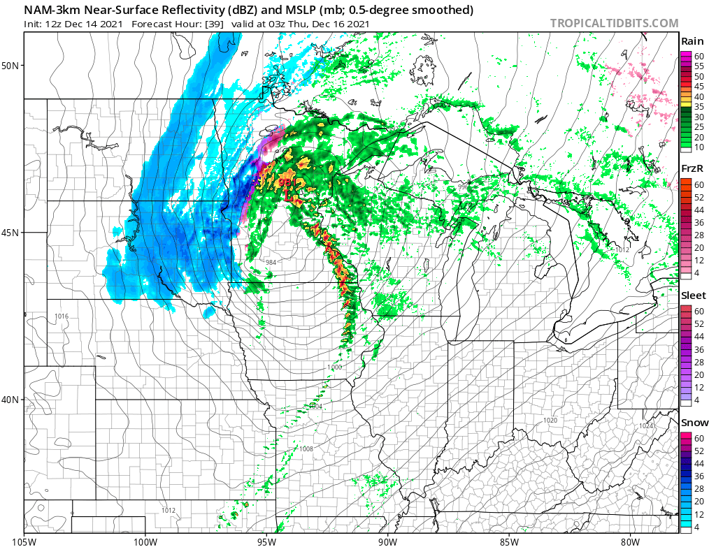
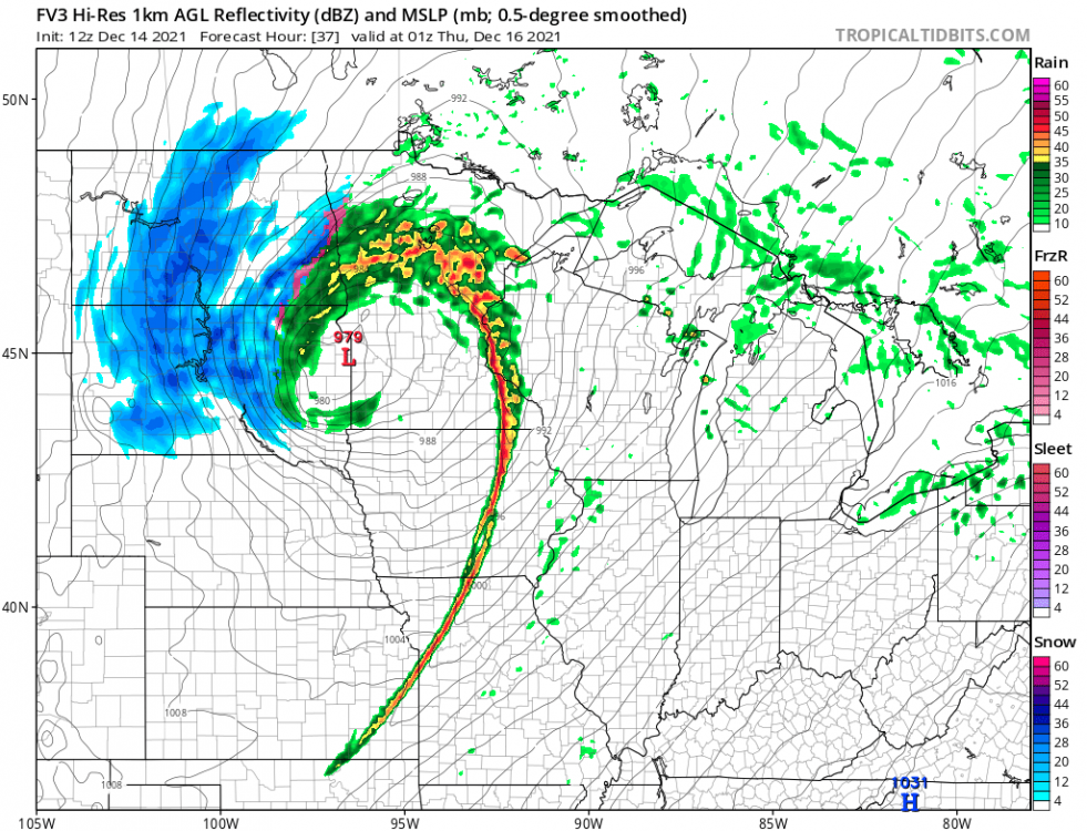
12/10 to 12/11 Upper Midwest Snow Storm
St Paul Storm replied to bud2380's topic in East of the Rockies
I live about 4 miles northeast of downtown St Paul. I took measurements in 3 different spots and ended up with an average of about 10.5”. Lost a few inches already, but holding on quite well. Tomorrow and Wed will be the real test to see if we’ll have a white Christmas. -
12/10 to 12/11 Upper Midwest Snow Storm
St Paul Storm replied to bud2380's topic in East of the Rockies
Brighter returns now shifting back to the northwest. Not as intense as the one earlier that smashed the south metro but it’s snowing hard out there. I’ll hit at least 8” here based on current radar. MPX with a winter storm warning update for the ages: ”...INCREDIBLE SNOWFALL AMOUNTS CONTINUE TO PILE UP THIS EVENING... Additional snow accumulations of 3 to 5 inches. Storm total accumulations of 18 to 21 inches are possible in parts of the southern and eastern Twin Cities Metro. Winds gusting as high as 35 mph.” -
12/10 to 12/11 Upper Midwest Snow Storm
St Paul Storm replied to bud2380's topic in East of the Rockies
Thanks. I’m on the mend, but it’s been rough. One thing is for sure…most models absolutely nailed where that band was going to set up. We need to remember this one for all the times the models don’t do well.