


snow_wizard
-
Posts
41072 -
Joined
-
Last visited
-
Days Won
40
Everything posted by snow_wizard
-

March 2024 Weather in the PNW
snow_wizard replied to TigerWoodsLibido's topic in West of the Rockies
It's something all of us have dealt with. The change of the clocks is well worth it at this latitude. I guarantee if we go to permanent daylight time everyone will be bitcching about the 9am sunrises in December. The people who want that change to be made don't think about that. -
March 2024 Weather in the PNW
snow_wizard replied to TigerWoodsLibido's topic in West of the Rockies
Talk about an atypical pattern for March on the ECMWF as far as surface pressure is concerned. An astonishing lack of low pressure over the NE Pacific. -
March 2024 Weather in the PNW
snow_wizard replied to TigerWoodsLibido's topic in West of the Rockies
Really nice retrogression signal on the GEFS tonight. -
March 2024 Weather in the PNW
snow_wizard replied to TigerWoodsLibido's topic in West of the Rockies
A big problem with the China match in the SE is some parts of China have brutally cold winters. -
March 2024 Weather in the PNW
snow_wizard replied to TigerWoodsLibido's topic in West of the Rockies
It actually shows the Portugal match way south of PDX. Up here I'm almost on the border of UK / France. Edit: Vilela Portugal is at 2,200 feet so it's like comparing apples and oranges. -
March 2024 Weather in the PNW
snow_wizard replied to TigerWoodsLibido's topic in West of the Rockies
I'm not sure. That map showed some strikes pretty close to here as well. Didn't hear anything, but it got very nasty for about 15 minutes or so. -
March 2024 Weather in the PNW
snow_wizard replied to TigerWoodsLibido's topic in West of the Rockies
The GFS has owned the ECMWF for precip this morning. The ECMWF showed a wet morning here and there hasn't been a drop. Not sure what is going on with the ECMWF lately. -
March 2024 Weather in the PNW
snow_wizard replied to TigerWoodsLibido's topic in West of the Rockies
The next winter was superb as well. -
March 2024 Weather in the PNW
snow_wizard replied to TigerWoodsLibido's topic in West of the Rockies
At this point I think the chances are pretty good we will get into a deep trough again during the later part of the month. We are in an amplified regime and the chances of a ridge staying put for more than a week are very low with big MJO wave in play right now. As the wave moves the forcing it causes in the mid latitudes will move as well. As for next winter....it's actually more likely than not it will be amplified based on recent trends alone. Some decades are simply more amplified than others and this one is up there in the blocking department. Add to that the fact we will probably have a Nina going with positive QBO, and you have a good likelihood the blocking will be in favorable locations for us. Big Nino to Nina transition is yet another thing our favor. This decade is on track to be a really good one for us overall. -
March 2024 Weather in the PNW
snow_wizard replied to TigerWoodsLibido's topic in West of the Rockies
All I know right now is the first half of March is going to have a very respectable average temp. SEA is running -6.2 through yesterday with another cold trough on the way before the big ridge. Big trough to ridge transitions are great for cold mins. -
March 2024 Weather in the PNW
snow_wizard replied to TigerWoodsLibido's topic in West of the Rockies
To further expound on the late snow thing. I was saying that late March / very early April 1936 was the gold standard for a widespread / notably cold late winter event. Snow in Seattle, Portland, and most lowland locations in WA and NW OR. The cold afterward was insane. Landsburg had a 40/20 and a 43/18 out of that which is on the order of -15 departures on those days. April has had notable lowland snow events such as 1911, 1945, 1972 and 2022, but they are not nearly as cold or widespread. Hope that clears it up. -
March 2024 Weather in the PNW
snow_wizard replied to TigerWoodsLibido's topic in West of the Rockies
That big lobe of high pressure just south of AK could do it though. With a big MJO wave in play I can't imagine the ridge staying in one place for too long. -
March 2024 Weather in the PNW
snow_wizard replied to TigerWoodsLibido's topic in West of the Rockies
Big retrogression is way better. -
March 2024 Weather in the PNW
snow_wizard replied to TigerWoodsLibido's topic in West of the Rockies
I specified widespread and very cold. 1936 had major snows over a very wide area that came in a couple of different waves. I think Justin would agree with me on this one. -
March 2024 Weather in the PNW
snow_wizard replied to TigerWoodsLibido's topic in West of the Rockies
Wow! Right now the MJO is saying go big or go home. That is one insane wave. -
March 2024 Weather in the PNW
snow_wizard replied to TigerWoodsLibido's topic in West of the Rockies
Not really. I've been pretty subdued the last few years. Last year I actually began my 6 month absence from the forum around this time. -
March 2024 Weather in the PNW
snow_wizard replied to TigerWoodsLibido's topic in West of the Rockies
For the record the latest widespread lowland snow event in the period of record here (basically 1848 to present) was at the very end of March 1936. A very significant snow event with much below normal temps afterward. There have been some notable snows in April, but not as widespread and not nearly as cold. -
March 2024 Weather in the PNW
snow_wizard replied to TigerWoodsLibido's topic in West of the Rockies
I'm already smelling a blocky regime next winter. It could be a really good one given the base state we will have. -
March 2024 Weather in the PNW
snow_wizard replied to TigerWoodsLibido's topic in West of the Rockies
Actually a trough like that is more cold than wet. -
March 2024 Weather in the PNW
snow_wizard replied to TigerWoodsLibido's topic in West of the Rockies
Only 43 here after a low of 38. -
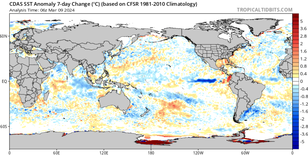
The 7 say change map kind of says it all!
-
March 2024 Weather in the PNW
snow_wizard replied to TigerWoodsLibido's topic in West of the Rockies
Hard to not like the 12z GFS. I really like where this year is going. Alternating sharp troughing and ridging can bring some of our best spring weather. Not much gloom, lots of cold nights, and some really enjoyable days. The worst type of spring IMO is when the pattern is flat and we get nothing but gloom and it drizzles on us day after day. -
March 2024 Weather in the PNW
snow_wizard replied to TigerWoodsLibido's topic in West of the Rockies
31.6! Another freeze. -
March 2024 Weather in the PNW
snow_wizard replied to TigerWoodsLibido's topic in West of the Rockies
Looks like number 7 for SEA. Same deal....coldest since 1989 and all the rest are pre 1975. Really weird how the first half of the 20th century was so unimpressive for March. -
March 2024 Weather in the PNW
snow_wizard replied to TigerWoodsLibido's topic in West of the Rockies
The EPS seems more inclined to retrograde the ridge a bit after day 10. More into what I like to call the cold night spot.


