


snow_wizard
-
Posts
41066 -
Joined
-
Last visited
-
Days Won
40
Everything posted by snow_wizard
-

February Weather in the Pacific Northwest
snow_wizard replied to Deweydog's topic in West of the Rockies
You guys will have to rely on cold coming down from the Fraser, but the air mass looks pretty D**n cold with good upper level support. -
February Weather in the Pacific Northwest
snow_wizard replied to Deweydog's topic in West of the Rockies
I think the last real flash freeze Arctic front we had was November 2010. That was the real deal for sure. This one sure looks like it will be decent with 850s crashing to -13 or so. -
February Weather in the Pacific Northwest
snow_wizard replied to Deweydog's topic in West of the Rockies
The ECMWF is still really nice at day 8. Block is very strong. -
February Weather in the Pacific Northwest
snow_wizard replied to Deweydog's topic in West of the Rockies
8 - 9 winter though.... -
February Weather in the Pacific Northwest
snow_wizard replied to Deweydog's topic in West of the Rockies
Another big improvement on the GFS ensemble tonight. The mean bottoms at -10 now with a good number of cold members all the way to the end of the run. -
February Weather in the Pacific Northwest
snow_wizard replied to Deweydog's topic in West of the Rockies
According to Weatherbell the 850s bottom out at -14 for Seattle. VERY impressive! -
February Weather in the Pacific Northwest
snow_wizard replied to Deweydog's topic in West of the Rockies
Looks like the GEM is having problems tonight. It hasn't even begun on the Environment Canada site. -
February Weather in the Pacific Northwest
snow_wizard replied to Deweydog's topic in West of the Rockies
That one looks interesting. A good slug of maritime polar air swinging in while another batch of cold continental air is advancing toward us. That together with trapped low level cold could work out well. -
February Weather in the Pacific Northwest
snow_wizard replied to Deweydog's topic in West of the Rockies
The Weatherbell map shows SEA with a high of 31 on Monday. -
February Weather in the Pacific Northwest
snow_wizard replied to Deweydog's topic in West of the Rockies
FWIW I am hard pressed to think of many examples of Arctic outbreaks after Valentine's Day that didn't have significant lowland snow at some point during the event. This thing has the earmarks of being a good snowmaker for many. -
February Weather in the Pacific Northwest
snow_wizard replied to Deweydog's topic in West of the Rockies
Very powerful Arctic front being shown on this run. 850s bottom out at -13 over Seattle. A definite flash freeze scenario being shown. Could top any February Arctic front in many many years. -
February Weather in the Pacific Northwest
snow_wizard replied to Deweydog's topic in West of the Rockies
This is what you're worried about right now? -
February Weather in the Pacific Northwest
snow_wizard replied to Deweydog's topic in West of the Rockies
Looks like fun times coming! There is an unmistakable early indication of another cold shot around day 9 or 10 if you look at the EPS and GEFS 500mb ensemble means. -
February Weather in the Pacific Northwest
snow_wizard replied to Deweydog's topic in West of the Rockies
Still a big positive anom over the northern GOA. It will be fine. -
February Weather in the Pacific Northwest
snow_wizard replied to Deweydog's topic in West of the Rockies
6 members on the 6Z GEFS go to -15 or lower on the 850s. -
February Weather in the Pacific Northwest
snow_wizard replied to Deweydog's topic in West of the Rockies
A couple of the top analogs are 1962 and 1955. Pretty good company! -
February Weather in the Pacific Northwest
snow_wizard replied to Deweydog's topic in West of the Rockies
What in the world is Jesse waiting for I wonder? -
February Weather in the Pacific Northwest
snow_wizard replied to Deweydog's topic in West of the Rockies
Maybe this will be the northerly flow dominated spring we are so overdue for. At any rate we might have several opportunities to pick up some snow over the next few weeks. -
February Weather in the Pacific Northwest
snow_wizard replied to Deweydog's topic in West of the Rockies
You don't see this every day! -
February Weather in the Pacific Northwest
snow_wizard replied to Deweydog's topic in West of the Rockies
1990 was a fabulous event that kind of gets overshadowed by 1989. 1988-89, 1989-90, and 1990-91 all had major events. Pretty amazing run. -
February Weather in the Pacific Northwest
snow_wizard replied to Deweydog's topic in West of the Rockies
The ensemble is notably colder than the 18z. Wow! -
February Weather in the Pacific Northwest
snow_wizard replied to Deweydog's topic in West of the Rockies
Given how low the dps are right now it could happen. -
February Weather in the Pacific Northwest
snow_wizard replied to Deweydog's topic in West of the Rockies
Another thing that will be interesting to watch on this is whether we can score two separate Arctic blasts. If so that would be extremely rare for a late season event. -
February Weather in the Pacific Northwest
snow_wizard replied to Deweydog's topic in West of the Rockies
Nice snow for King County on this run. The Weatherbell maps also show two days with freezing max temps.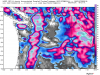
-
February Weather in the Pacific Northwest
snow_wizard replied to Deweydog's topic in West of the Rockies
The GFS is certainly into historic territory for duration of a late season cold wave. It shows one reinforcement after another.

