


snow_wizard
-
Posts
41072 -
Joined
-
Last visited
-
Days Won
40
Everything posted by snow_wizard
-
Kind of interesting looking at the years being talked about here...1929, 1949, 1962. All were followed by very cold Januaries.
-
I'm still thinking frost for Friday night when the gradients die.
-
Just a tad of similarity between this year and 1949 for the first 22 days of October over the NE Pacific and GOA. Then of course 1949 had a big ridge the final 5 days of the month. Very good match!
-
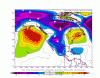
This is very exciting. Unprecedented high pressure anoms at 45N - 150W for the month of October. Huge potential this winter.
-
Truly unbelievable how little low pressure the ECMWF shows over the NE Pacific during week 2. There is one day the lowest pressure over the ENTIRE North Pacific east of the Date Line is 995mb. It's a literal parade of upper level and surface high pressure systems. As Phil said yesterday it's like a log jam of ridges that eventually leads to retrogression. In the winter this would be an epic cold situation for much of the country.
-
Friday night / Saturday looks excellent for an inversion. Very weak offshore gradients when dry air will be in place from the recent clipper. Should be a good chance of frost in many areas and then very weak gradients allow the cold air to sit over us on Saturday. Right after that the surface gradients take on an Arctic outbreak look and much lower 850s get ushered in. Looks like a series of cool continental surface highs dropping down over the next 10 days. The one in very early November could be interesting.
-
This is actually the part of the year that often sets the tone for the winter. We're going to get nailed this time. Take it to the bank.
-
Way overstated IMO. The clipper still drops the 850s pretty sharply and there will be chilly nights in many places. Even if it does get as warm as you think we're in really good company historically speaking.
-
Just amazing blocking on the 0z GFS. The Pacific is totally shut down for the next two weeks. That is a really crazy retrogression a little ways down the road.
-
The fall colors are really popping here now. The broadleaf maples are quite vivid compared to normal and some cottonwoods look like they could turn really good this year. Some of the non native trees are absolutely on fire.
-
I love it!
-
Looks like a classic two steps forward one step back regime on the Nina this season. Plenty of room for it to warm after the big drop in the past week.
-
Looking at the surface pressure gradients later this month we look well set for an inversion with very weak gradients developing and warm air aloft.
-
Even the GEM shows a lack of low pressure over the NE Pacific though. That has been the screaming message on every model run. Huge implications.
-
I think the winter is already set to be good.
-
Pretty big changes on tonight's GFS. Looks like more ridging tries to build further west. The impressive thing about all runs is the continued lack of low pressure over the NE Pacific. This is the time of year that often sets a precedent for winter in that region. Obviously if we hold onto that theme this winter we will have a fun one!
-
Very true.
-
Looks like we have a robust Nina and a negative PDO now. It took a long time for the North Pacific to finally reconfigure.
-
Very possible given the MJO will be more favorable by then. I'm hoping for more of a warning type cold snap than a big event that early.
-
True. The 1950s may have been harsher up this way. Jan 1950 was quite a bit colder at SEA than PDX.
-
Can't forget March 1951 and March 1955. March 1951 is the snowiest month on record for some stations and SEA dropped to 11 in 1955.
-
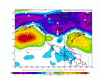
I'm beginning to think we might see a cold snap of some sort sometime during the first week of November. Such a big and persistent ridge could certainly retrograde without much warning. The 12z ECMWF ensemble shows a retrogression signature at day 10 and the GFS ensemble mean shows a steady 850 drop during week 2.
-
Yeah. The anomaly center placement and intensity we saw with the two big troughs in the past month was certainly 1950ish. There were some similar in the 1980s to mid 90s also.
-
Not many stations were recording in Western WA in the winter 1898-99, but Sedro Woolley (just south of Bellingham) paints an interesting picture. They actually had 3 major cold waves that winter with a total of 20 max temps of freezing or lower with a decent amount of snow. Normally a winter like that here would mean a torch in the East. Just goes to show what is possible and in fact probably common during colder climate regimes.
-
That seems nearly impossible, but it almost has to be true unless there was a shallow layer of very cold air at the lower levels.


