Phil
-
Posts
44489 -
Joined
-
Last visited
-
Days Won
262
Everything posted by Phil
-
The impressive speed of this CCKW across the Pacific is another indicator the niño is losing its grip on higher frequency elements of tropical forcing.
-
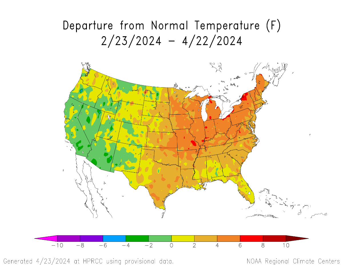
The last 2 months have already established a warm CONUS pattern which, when manifesting during post-niño springs, almost always precedes warm summers nationally. This bears striking resemblance to spring 2010. Only difference is cool anomalies aren’t as prevalent (I suspect the same will hold true during the summer).


-
This would be a closer match to 2010 than 2012. Because 2012 wasn’t coming off a strong niño, where-as there are still niño-like elements to the current base state (albeit attenuating). Of course there will be subseasonal scale differences as well. Unwise to project from any analog pool alone.
-
You don’t have a point. The context was *leaving town* on a day with desirable weather, to a destination with more desirable weather. Not *returning home* to desirable weather.
-
You feel a lot of things.
-
A more in-depth analysis of the event from Rollenbeck at al, 2022: https://www.mdpi.com/2072-4292/14/4/824 Note the murky overlap between EOF(s) defining niña-modoki and niño-costero. The truth is ENSO has multiple spectra, and the niño 3.4/ONI metric is out of date (and should be done away with entirely) because it fails to capture several components of ENSO variability.
-
The 2023/24 niño emerged from a niño-costero event. First time we’ve seen that type of evolution before the 1976 Pacific Climate Shift. This is fascinating stuff when you really dig into it.
-
This is an informative read: https://link.springer.com/article/10.1007/s13753-017-0151-8
-
I think you know the answer to that one.
-
The Niño 3.4 number doesn’t tell the whole story. There was a healthy, quasi-stable niña low pass signal during the first part of that winter. The atmosphere was well coupled. There was no major intraseasonal event (MJO/SSW et al) that could have torpedoed the base state like that. Not only did it abruptly fall apart without warning, but come February the atmosphere had coupled to the niño-costero signature as if it was a mature niño event. That’s not supposed to happen. It’s cute you think it’s as simple as a cursory glance at the niño 3.4 number, though. I used to think that way..when I was 11yrs old.
-
Colorado-like diurnal cycle today. 35°F at 7AM to 71°F by noon. Will miss this come July when it feels nastier at 9PM than it did at noon.
-
You have T-mobile? I’ve only heard awful things about them.
-
I always get the in-flight WiFi too. Can only play sudoku and minesweeper for so long
-
It’s healthier to talk about your feelings as opposed to bottling them up. Try it sometime.
-
That’s not true for me, but we’re all different I guess. We used to go skiing in UT and I enjoyed snow events there just as much as here. One of our trips actually lined up with a historic spring storm there, went to bed with strong SE winds and drizzle, woke up to 12-18” of snow and strong W/NW winds. I’m still salty I slept through the overnight chaos..the progression of weather conditions basically mirrored a strong miller-B nor’easter out here.
-
Nov/Dec maintained the weak niña base state, but that regime imploded in January. It was quite remarkable, actually. By February, the niño-costero signal was stronger than the preceding niña ever was. Then it abruptly collapsed in May/June, and a more substantial EPAC niña signal emerged during summer 2017 (though it was still disconnected from the PMM/IPWP state..the entire system state appeared disheveled and confused in the years following the 2015/16 super niño). I figured you guys would have some intellectual curiosity on that front, but apparently people would rather cling to preconceived notions because of how the weather behaved in their backyards. Sad.
-
I digress, as evidenced by my non-response. We all have our own unique oddities. Sometimes those oddities are weird weather preferences, sometimes it’s other stuff. No amount of debate on a weather forum will change that.
-
I deny fairytales, yes. 2016/17 wasn’t a niña. Niño 3.4 was in positive territory before the end of January. Look at SSTA maps from Feb-Apr 2017. Legit niño-costero signature in both SSTAs and OLR/atmospheric circulation.
-
But you’ll see more sunny/70+ wx in SC than you would in WA. So what are you missing? I don’t get it. If I was missing a 4” snow event here but traveling somewhere where a 12”+ snowstorm was headed, I wouldn’t be salty about “missing” the 4” one. That’s just weird.
-
Tropical forcing was already El Niño like by spring 2023, despite the lack of an official declaration. January 2023 was an intraseasonal event but was also a harbinger of things to come. Couldn’t know this in real time, but the ocean/atmosphere system had already made up its mind about where it was going at that point.
-
Can I this one a J***e pattern? If it isn’t, I can’t imagine what would meet the criteria.
-
I’ll never forget how it snowed on May 9th, 2020. Absolutely obliterated 850mb cold records with that one. Why does it matter if you’re traveling somewhere even warmer/sunnier? It’s not like you’re missing a snowstorm or something. You mean El Niño? Sadly yes, it is on its deathbed.
-
2 months from now it wouldn’t, though. Climatology is factored in. For instance, the first hot pattern of summer is often harder on the general population, since people aren’t acclimated yet.
-
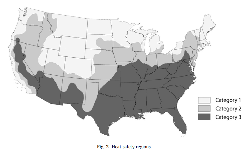
I’ve also heard that a heavier emphasis will be placed on WBGT (wet bulb globe temperature) w/rt heat headlines in the future. It is a better measure than heat index. Thresholds will vary by region, of course. Criteria in SE US/Desert SW will be different than the PNW, for instance.
-
Yeah basically it’s calculated with respect to each locations’ climatology (in addition to factors such as duration, diurnal cycle, and parameterization to extrapolate dewpoint, etc.