


Phil
-
Posts
44451 -
Joined
-
Last visited
-
Days Won
259
Posts posted by Phil
-
-
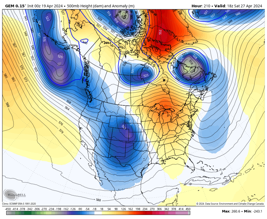
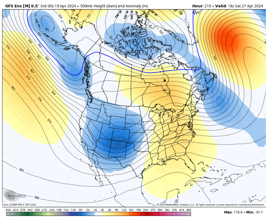
The 00z CMC and GEFS both have that zonal/onshore flow pattern establishing during week-2. A J***e delight.
-
 1
1
-
 1
1
-
-
4 hours ago, ChrisEl Elyon said:
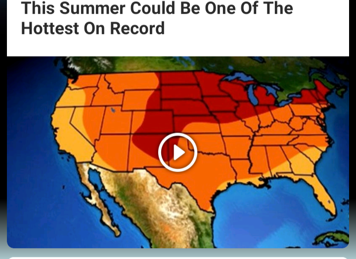

Been saying this for awhile. 2024 will probably be the hottest summer on record for the lower-48. All forcing components are lining up in the worst way possible.
-
 2
2
-
-
5 hours ago, TT-SEA said:
Not sure what NOAA is seeing...
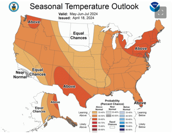
Where they have “equal chances” is probably where the warmest anomalies will end up. Lmao.
-
 1
1
-
-
7 hours ago, TT-SEA said:
Man it's gorgeous out. Piercing blue sky and pleasant temp. Perfect April weather.
A week ago Phil was talking about this period being a Jesse-tastic pattern. Turns out it's a pattern almost everyone loves.
Huh? No I wasn’t. Unless it was an in-jest comment about a single long range model run.

-
12 minutes ago, SilverFallsAndrew said:
Whatever
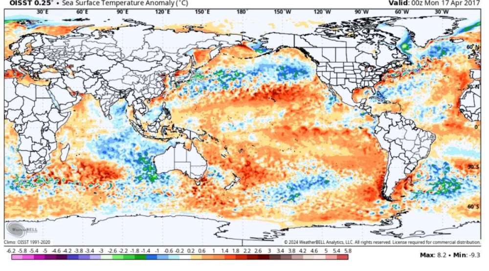
This is what 2017 looked like on this date.
LA NINA!

-
 1
1
-
-
4 hours ago, Cold Snap said:
Yeah they are even saying May is probably going to torch for us. I feel like this isn’t going to be as hot as last May though.
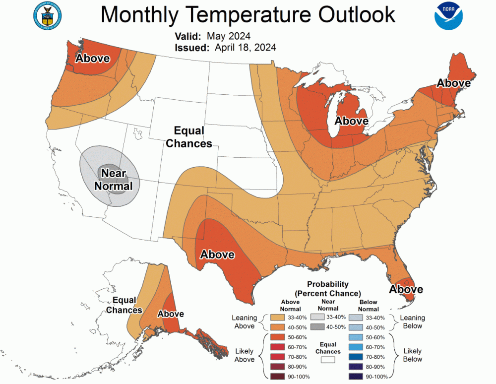
NOAA has been having a rough time lately. Horrible busts last winter on both the seasonal and subseasonal scales. Idk what their methodology is but it’s been failing them since the niño established.
IIRC they rely heavily on the IRI which is notoriously bad when seasonal/LF forcing components destructively interfere w/ canonical EOFs (example: strong niño in tandem with -PMM).
-
3
-
-
8 hours ago, BLI snowman said:
Funny enough, the last few big snowpack years in CA were all *drumroll... Niñas!
2010-11, 2016-17, 2022-23.
La Niña truly brings the nourishing juices of life to all. Particularly to the Mid Atlantic states, where it allows the newly-native flora to thrive as it works to further expedite the transfer of the humid subtropical climate/bioregion into your neck of the woods.
16/17 was full blown niño-costero by Feb. Calling that winter a niña borders on criminal.
-
 1
1
-
1
-
-
38 minutes ago, TT-SEA said:
Yes... this would solve everything.
")
.thumb.png.ea11fbe5b077fa3f49f3ca7ac253820e.png)
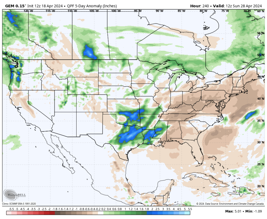
The first 5 days are dry but the faucet of life
 turns on week-2.
If the pattern evolved exactly as modeled, it actually might “solve” a lot (esp extrapolating that pattern forward). Doesn’t mean it will verify but it’s one of the possibilities.
-
1
-
-
28 minutes ago, Cascadia_Wx said:
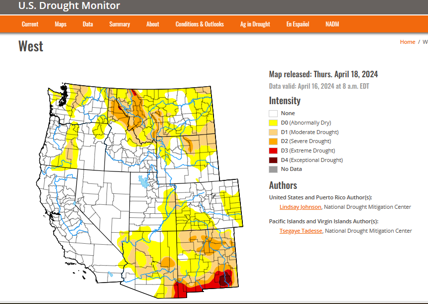
Too bad random model runs can’t end drought. It takes actual rain!
I’m actually optimistic about a wetter pattern as the MJO returns to the E-Hem. Maybe not quite to the level of the 12z CMC, but in that general direction. There’s nothing in the system state to suggest 2024 will be a dry tinderbox in the PNW.
That said, those in CA/SW US should keep a watchful eye as the second half of this year could flip dry. Good thing those reservoirs are filled to the brim because La Niña will take no prisoners once it establishes.
Only “good” news is we shouldn’t have the godzilla-like 4CH roasting the intermountain west this summer. Will be at least somewhat flatter/suppressed, but not to the extent of 2008 where it was almost nonexistent. More likely to resemble 2020 or 2010.
It probably won’t be enough to stop a very warm summer nationally, though. The broader mid-latitude pattern looks ugly, and I suspect the entire lower-48 (including WA/OR) will run warmer than average. But the nastiest stuff will probably center in the Plains or Midwest, not at the coasts.
-
1
-
1
-
-
The 12z CMC would put any drought worries to bed.
-
2
-
 1
1
-
 1
1
-
1
-
-
1 hour ago, TT-SEA said:
If its any consolation... the "drought" prone areas are generally related to mountain snow and its really hard to make up mountain snow deficits in May regardless of the pattern.
Shouldn’t you be sipping martinis on the beach right now?

-
1
-
-
1 hour ago, Cascadia_Wx said:
Never underestimate the crapulence of that station.
They hit 39!

-
 1
1
-
 1
1
-
-
1 hour ago, Cascadia_Wx said:
Never underestimate the crapulence of that station.
The fact these urbanizing UHI stations are relied on so heavily in surface climate datasets is a joke.
It’s obvious sfc datasets are corrupted because the vast majority of “observed” warming has occurred at night, even in areas where cloud cover has declined. Also, satellites are in near perfect alignment w/ sfc datasets over the oceans, but on land sfc datasets are warming up to 2X faster than satellite data in some areas.
Yes, GHG-induced warming will also skew slightly higher at night (for a multitude of reasons that require lots of jargon to explain), however it’s a minuscule difference when you actually calculate it, even if you are extra generous w/ how you construct the “fractal” of diurnal/nocturnal fluxes.
-
5
-
1
-
-
1 hour ago, TT-SEA said:
It will inevitably change or get watered down.
FWIW, one of the leading Apr-Jun EOFs during p8-1-2 transitions in waning niños is troughing at the coasts and a ridge in the middle of the country. There are other possible outcomes (subseasonal responses are always state dependent), but I could definitely see that pattern verifying.
-
3
-
-
59 minutes ago, LowerGarfield said:
Is there any place for April? It and May look similar.
South FL. Don’t see May anywhere, though.
-
If that isn’t a J***e pattern on the LR GFS then I don’t know what is.
-
1
-
-
September has changed so much out here it’s incomprehensible. When I was a kid in elementary school it regularly produced legitimate autumn weather. Now it’s nastier than June.
Though we had some awful Septembers in the 19th century (including the record of 104°F in the 1880s) so there’s probably an element of internal variability to it.
-
 1
1
-
-
13 minutes ago, Cascadia_Wx said:
I used to love September around here too. The heat of summer starts to fade, nights get cooler, afternoon shadows get longer, those first crisp mornings hit, usually we get our first fall rain event at some point in the month.Or even just an abrupt all day marine layer with drizzle and sudden highs in the 60s. Often get the first really foggy morning at some point the last half of the month. Leaves start to change. Just a lot to like.
It’s not as great these days with September being an extension of smoke season more often than not. There have still been some decent ones in recent years, but they are more few and far between than they used to be.
I’m probably biased.
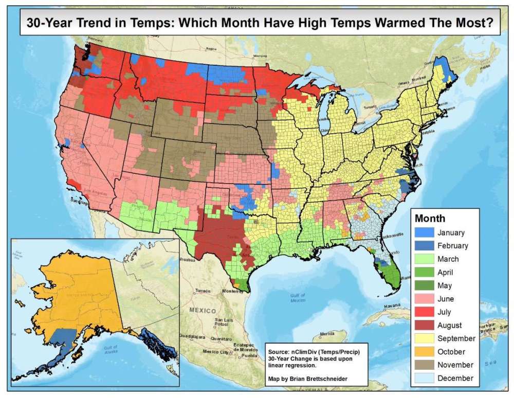
Looks like Aug and Jan have the ugliest trends up there.
-
2
-
1
-
-
There are a bunch of them strung together on a light wind shift so there’s a slightly better chance they reached 39. Tho not guaranteed.
If it was gyrating back/forth between 39 & 41 that’d suggest they’re hugging the rounding threshold and likely didn’t make it. Guess we’ll find out soon.
-
1
-
-
1 hour ago, Phishy Wx said:
apparently the Dubai mega flooding was cloud seeding gone wrong. Opps!
That may have added to it, but the setup was ripe to produce heavy rainfall regardless.
I’ve generally been unimpressed w/rt evidence of effectiveness of cloud seeding. Seems to make more of a difference in marginal situations as opposed to setups ripe for deep convection and heavy rain.
-
1
-
-
1 minute ago, Cascadia_Wx said:
Could have something to do with living in different climate thousands of miles away from yours.
That still doesn’t compute. I get autumn is more exciting in the PNW but September pretty “blah” everywhere.
-
1
-
-
1 hour ago, Phishy Wx said:
over here the only deciduous have been human planted for the most part. I mean there are some cottonwoods in the river bottoms, some Aspens around but most are ornamental. New England fall is almost religious some years. one of my best memories of living in NH
Inverse out here, most conifers are human planted. I have one volunteer pine growing right now, which is the first time it’s ever happened.
Meanwhile deciduous hardwoods pop up like weeds everywhere throughout the year. Any piece of land left alone will be forested within 30 years. Ma’ nature desperately wants to reclaim the earth from us human vermin.
-
3 minutes ago, LowerGarfield said:
This is such a bad article and doesn't take into account local conditions or wildfires. How can you accurately predict that Seattle will have three weeks of bad air at this point? https://mynorthwest.com/3957635/brace-yourself-for-weeks-of-poor-air-quality-in-2024-seattle-residents/
You can’t.
-
4
-
1
-
-
1 hour ago, Rubus Leucodermis said:
September used to be my favorite month, prior to about 15 years ago. Now it is one of my least favorite.
Why was it ever your favorite month?
-
1
-


.png.0f60e97e59c3e74c6ed4a9ddc0fa187f.png)


April 2024 Weather in the PNW
in West of the Rockies
Posted
Maybe if we get this pattern out of the way in spring it’ll reverse during the summer.