


Phil
-
Posts
44489 -
Joined
-
Last visited
-
Days Won
262
Everything posted by Phil
-
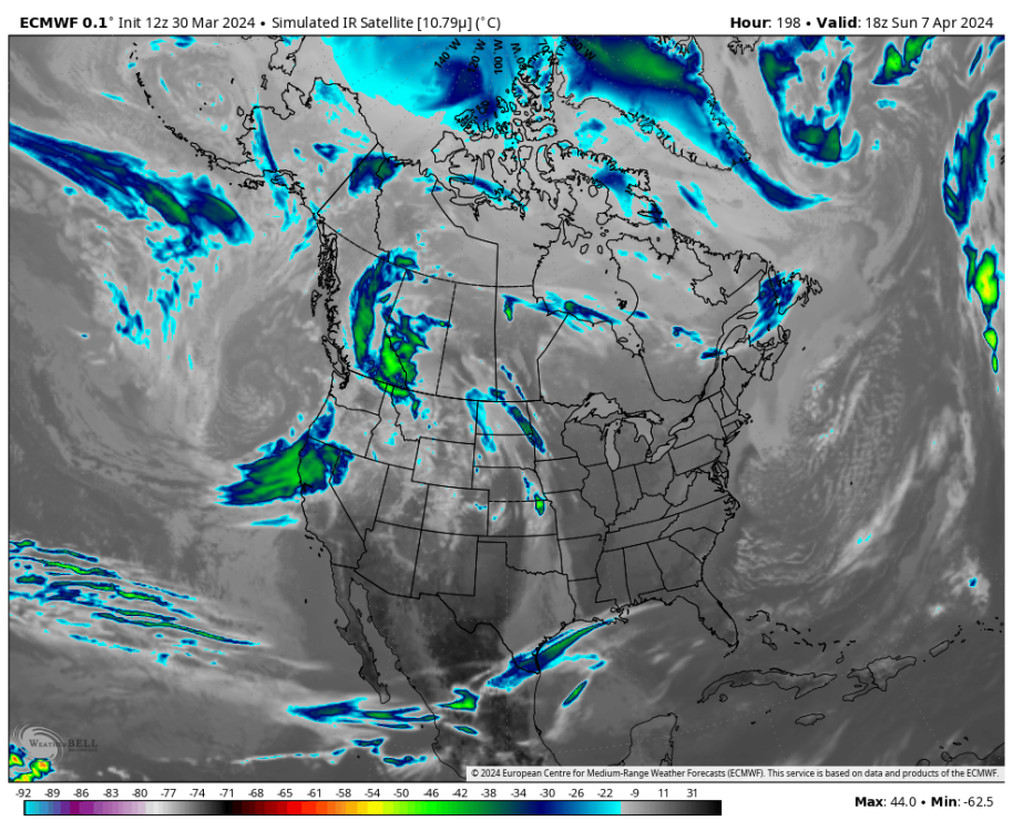
Those maps are almost certainly overdone. I know how these spring patterns work out here, this is a classic archbambault progression. Skies will be largely devoid of clouds under anticyclone descending from Canada, westward until the midway through the belt of return flow (which will be somewhere in the vicinity of the Plains). Fortunately this is a very stable, predictable pattern. Question is how quickly the next system ejects out of the Rockies. Texas/S-Plains into MO/AR are the areas with reduced certainty.
-
Can’t say the result will be to your liking (or even regionally-relevant) but the general circulation from the Indo-Pacific across the subtropical NPAC has definitely changed following this strong niño. The post-2016 -SPMM/+NPMM dipole and associated ITCZ structure is no longer (which is admittedly not what I had expected going into this niño, but in hindsight it should have been obvious and I’m a fool for missing the leading EOF(s)). It is common if not expected for super niños (or any healthy niño emerging as an EPAC/costero event) to alter intradecadal axisymmetric background states in the tropics/subtropics (particularly stemming from the IPWP and off-equator NPAC) . Prolific examples of this (albeit w/ different/unique modes of variance) are 72/73, 97/98, and arguably 15/16 as well. More moderate examples include 82/83 (volcano mediated) and 86/87-87/88 (strange 2yr niño w/ out-of-season amplitude maxima). It’s been too long since the last analogous response (assuming accurate reconstruction) to gauge how this will manifest in the NH pattern in this climate era. Could make no difference in the PNW region at all (or be seasonally restricted). It’s also possible there will be a hemispheric-wide shake-up, for better or worse, or perhaps it will manifest most coherently in other parts of the NH. Whatever the outcome, I’m fairly confident we’ll look back at this niño as another one of those intradecadal shifts, in one form or another.
-
Are you time traveling?
-
Nah, Mossman wears black-frame glasses. Like the hybrid offspring of Jesse’s hipster glasses and Tim’s Harry Potter glasses.
-
If anything the axisymmetric components of this niña transition are worse for North America in terms of heat/drought than early the 2020s. Don’t think there will be any “blue” colors anywhere on JJA CONUS temperature maps this summer, not even in the PNW. People living in the Midwest and Plains should be in panic mode. That area looks like ground zero for hellfire (shifted a bit from 2021 & 2022 but same general theme).
-
EPS weeklies suggest this is the last niño-like MJO transit before a lower frequency signal for IPWP/dateline subsidence takes over in May. Sad. Haven’t we had enough niñas lately? Blech.

-
12z Euro looks decent overall for eclipse viewing. Some of those cloud cover maps are way overdone, counting super-thin high cirrus as 100% cloud cover. Big question is how soon that next system ejects out of the Rockies.
-
I didn’t start the conversation, shepherd boy. I joined one that was already ongoing.
-
There are 3 species in Oregon. “Okanagana Bella”, “Okanagana Canadensis”, and “Okanagana Rimosa”. All annuals. https://www.cicadamania.com/cicadas/common-cicadas-of-north-america/
-
Can see the influence of the SW monsoon, and GOM SSTs/Bermuda High clearly in those averages. FWIW the reason high temps begin to decline here in mid/late July is because humidity is increasing. Dews can peak a month later than temps in strong BH summers.
-
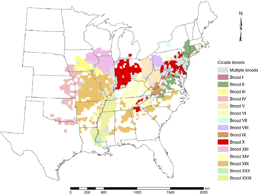
Nah, these are broods XIII and XIX. Weak emergence here compared to the monster that is brood-X. In fact many of these broods likely split from brood-X hundreds if not thousands of years ago. It’s likely brood-X was the first/original brood following the end of the last ice age.
-
I can confirm this is true. The annual ones are bad enough. The 13/17yr swarms..lmao.
-
It was also amazing to watch how they overwhelmed predators by sheer numbers. The first day they started emerging there were birds and squirrels everywhere eating them like candy and I was thinking how hell do they survive such predation. But the number emerging kept increasing each night, until those crunchy crawling sounds filled the night air, and every tree was encased in cicada husks. It was an onslaught, almost beyond comprehension. They just kept coming. Predation was overwhelmed within a week.
-
We had ours in May/June 2021 and holy s**t it was loud. When I spent more than 10 minutes outside my hearing was muffled afterwards for the next hour or so. The buzzing ones were so loud my phone couldn’t handle the decibel load, you can hear how it gets kind of fuzzy at each crescendo.
-
Can’t say at this range but my hunch is the farther NE you go the clearer the skies will be.
-
That’s less than 12 weeks away.
-
LF analog composites keep getting worse and worse for summer. Horrific coast to coast death ridge signal all the way through. Looks like some 1930s s**t.
-
Yay more cold rain followed by dry 60mph downsloping.
-
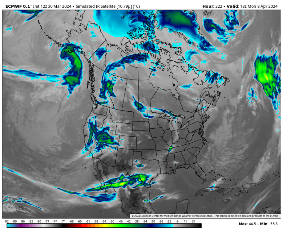
Go farther NE. Our plan is to catch the eclipse at Lake Loramie, OH. But maybe you’ll catch a tornado instead.
-
I still see clouds.
-
Is that what you think I did? Is it possible that I shared my experience with Chris so he knew he wasn’t alone in dealing with such issues? He said the experience scared him, I was trying to make him feel better. That’s all.
-
I’m sorry man. F**k the health insurance industry. Just a bunch of greedy swine.
-
Probably best to ignore the “climate emergency” accounts on social media. Most of their posts either lack context or are outright false.
-
For those of you traveling to TX, there’s a chance you’ll end up smack dab in the middle of a tornado outbreak instead. That 12z ECMWF run is cringe. Giant wedge tornado during the middle of an eclipse would be one hell of an acid trip (except it would be real, hehe).
-
Re: eclipse. -NAO/Archambault pattern to open April suggests cyclogenesis in NE US in the days leading up to the eclipse. That signal is pretty strong. Which suggests that, by eclipse day, confluence will be sliding off eastern Canada and high pressure will be building into OH Valley if not already present. So I like odds for clear skies from OH/IN into NY. Plains/Central US more vulnerable to WAA/clouds ahead of the next storm system by that point.


