Phil
-
Posts
44443 -
Joined
-
Last visited
-
Days Won
259
Everything posted by Phil
-
@Timmy Supercell
-
The GFS is useless for cloud cover.
-
That’s what I said.
-
I’m dumber than a sack of rocks.
-
Hahahahahaha. Holy s*** I see what I did now, it’s that button on the top right of main page. Somehow was oblivious to it until now.
-
Or I just didn’t notice it before. That level of ADHD isn’t beyond me.
-
Loving the new option to view the entire forum as opposed to switching between regional subforums. So much easier.
-
This type of setup is less reliant on insolation/sfc heating than the kinematic/forced components, relatively speaking. If you’re near/south of the warm front, you’re in the game. NW flow aloft with low level WAA is notorious for nocturnal severe, both super-cellular and MCS-type variety. Generally speaking, SBCAPE/surface heating becomes more important later in May into the summer months. But of course it’s not always the case..each situation is unique to some degree.
-

-
Seasonal/climate models will typically default to the canonical ENSO response, particularly during boreal winter. The components of subseasonal variability are always underestimated, and in fact are near impossible to project dynamically from such ranges. Seasonal forecasting is actually the area where AI/statistical models have the greatest potential to improve predictability. Factor in enough inter-related components (QBO, subseasonal modes of tropical forcing such as MJO, ERWs, & OKWs, Atlantic/Pacific meridional modes, annular modes, ENSO, etc) and their statistical+dynamical relationship(s) with one another, and you will see a substantial increase in predictability in both seasonal and subseasonal frequencies at very long ranges (possibly 6+ months).
-
D**n. Andrew had better watch his back.
-
Omg STFU. Demonic insomniacs. IMG_1125.mov
-
holy ducting thunder batman. I felt that in my chest.
-
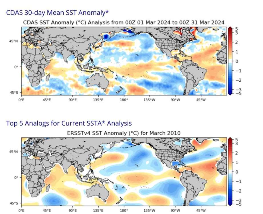
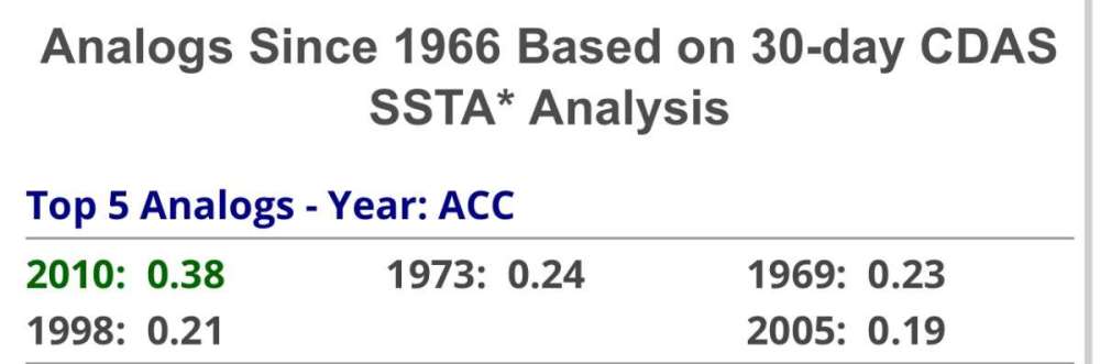
The global SSTA match with 2010 borders on spooky. Far and away the closest fit, with 1973 the runner-up. Also the descending NE-Canada block fits the 2010 progression. As does the descending +QBO with -PMM/+AMM. Below are SSTAs in 2024 (top) and 2010 (bottom) with global anomaly adjusted to zero. Crazy homogeneity.
-
Last time we had back to back nights with thunderstorms in March was 2010. Noticing a lot of similarities to that year, though timing shifted a few weeks.
-
Satan = ridging. God = troughing.
-
18z GFS looks Jesse-tastic.
-
Lmao. Keep in mind this is occurring with the backdrop of my comical ordeal after chasing in Plymouth. It’s another Phil story I’m sure half of you won’t believe, but it’s the perfect microcosm to summarize my life to-date. Trimmed from my previous post, but I went up there solo for the Jan 2022 blizzard, and let me tell you…driving a small sedan off the cape after 2+ feet of snow, frozen storm surge over wash, and power lines down everywhere was NOT easy. Praise Jesus that New England clears roads better than DC, or I would’ve been screwed. Had initially planned to spend another night at the pilgrim sands assuming I’d be snowed in (I wasn’t), but power was out and many of the ocean facing windows were broken, so it was cold as hoth in there. Everyone noped out of there by sundown. Even then I would’ve been fine, but my sister insisted I layover at her apartment in NYC, and after doing so I ended up running over a piece of plywood half buried in the snow w/ nails jutting out. Because, of course. My 10yr old donut held out just long enough to get me to an Acura dealer. Went flat right as I got there. Ultimately ended up spending as much $$ as I would have on renting an SUV, bc my insurance policy was El Cheapo. So yeah, her criticism isn’t without merit.
-
lol I missed this. It’s not like that, I already got her to take off work 4/7 - 4/9 to travel to OH with me. If we hit New England first we’ll have to pay for a hotel, and driving a Camaro into a blizzard comes with..risks (tho I’ve done it before, heh). I could go myself, but I don’t want to drive home then make another trip over the Appalachians and back.
-
Damn, you must have a short growing season.
-
If the transition to +QBO is rapid like 2010, and the IO remains warm, then of course a strong(er) event is statistically favored. That would be a relatively clear-cut forecast as the entire analog pool would consist of moderate/strong niñas. But probably a single-year event (IMO). If it’s a slower, poorly integrated transition, I’d expect a garden-variety niña that peaks early, before attenuating to neutral during F/M/A, with the middle latitude pattern becoming less “niña like” as winter rolls on. But of course, statistically favored outcomes don’t always come to fruition. We’ll find out eventually.
-
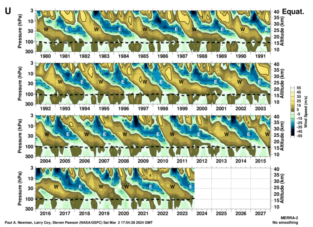
What didn’t I elaborate on? I defined the SAO (think of it has a faster version of the QBO occurring higher up). Timing of +QBO transition matters because it affects tropical convection to some degree. Faster transition will boost off-equator convection and intensify the Walker Cell relative to the Hadley Cell, aiding the development of La Niña over the summer. Vice versa for a slower transition. Years like 2010 (with subtropics/PMM and ENSO in alignment) saw shear stress downwell very quickly. Where-as on the other end of the spectrum you have 1992. Of course there are multiple factors involved (inertia of thermocline/intensity of upwelling kelvin wave activity, in-situ state of the PMM, warm-water volume within the indo-pacific warm pool (and its overall structure), etc). But the QBO plays one of the more outsized role regarding how “well integrated” transitioning ENSO is with modes of extratropical circulation, which is very important for sensible weather in the PNW and other middle latitude regions. For instance, you can have a sharp transition from niño to niña, but the extratropics are somewhat dissociated and take longer to synchronize. A primary example of this is 1998. Where as 1973 and 2010 are very well integrated transitions.
-
Very possible. The next intradecadal E-ward extension of the Indo-Pacific Warm Pool is due any year now. Once that happens, the post-2016 niña-tendency will dissolve. Doesn’t mean the rest of the 2020s will be dominated by nonstop niños, but ENSO amplitude will decrease overall, with more frequent garden-variety niños, while -ENSO episodes become weaker, more EPAC-centered, and less frequent overall. Some previous examples are 01/02 - 05/06, 91/92 - 94/95, etc.
-
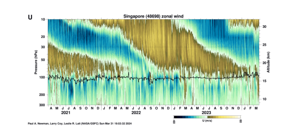
Crucial period coming up in May w/rt speed of +QBO transition. Downwell of westerly shear typically occurs following the third westerly SAO (stands for “semi-annual oscillation”, occurs above QBO at a higher-frequency interval, with a terminus around the stratopause). That is statistically favored to begin sometime in late April, at which point the descent of westerly shear will begin in the tropical upper stratosphere. Clues as to rate/amplitude of niña transition and the summer pattern will become much clearer roughly 6 weeks thereafter (from late May to late June depending on precise start time).
-
Mother nature will read her verdict soon enough.