wxmet
-
Posts
1522 -
Joined
-
Last visited
Everything posted by wxmet
-
UKMET 00z 96 hrs total snow:
-
Woah
-
It's not consistent with the other models and it's been jumping around quite a bit due to being unable to handle the upper level low in a data sparse region. Generally, you would side with the model with the best data assimilation which in this case is the ECMWF. The GFS has also been trending on a large scale towards the ECMWF but it's not all the way there yet.
-
GFS tosses that low to the south missing most if not all of us. I don't believe anything this run is showing.
-
GFS looks a bit north at 72 hrs compared to 18z. Probably because it's digging the B.C. trough out more on this run.
-
A bit better run for PDX on the 00z RGEM
- 8730 replies
-
- 10
-

-

-
RGEM showing a C-zone developing Wednesday night
-
They look like they're worlds apart.
-
Wow almost 4 inches here. Would be great if this verified
-
Wait for the HRRR to come into range and you’ll essentially have that
-
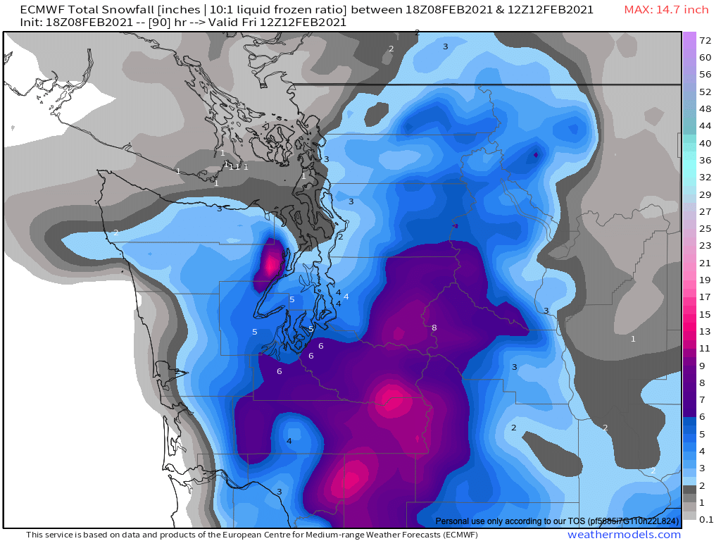
Totals early Friday morning

-
Looks similar to the RGEM where things cool back down to transition to all snow.
-
The upper level low in the Pacific is tricky to forecast. My guess is data sparseness. My guess is the ensembles will look similar to 12z. Maybe a tad more north.
-
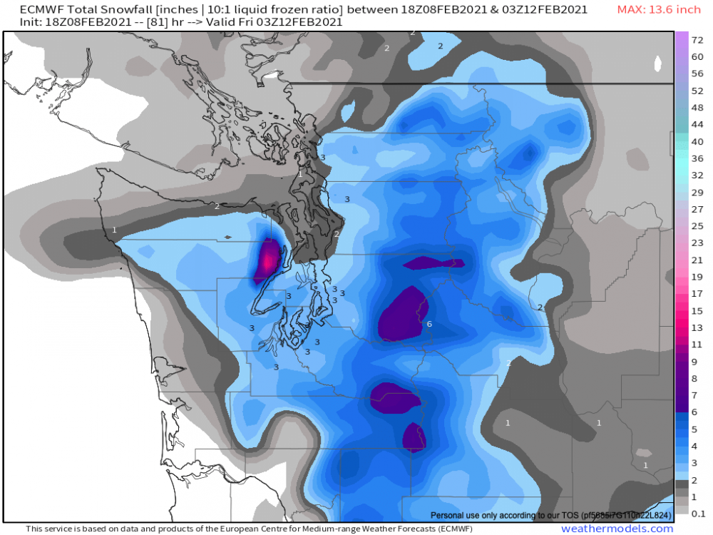
Looks similar to the RGEM 18z:
-
Much further north with the low a frozen precip compared to 12z.
-
-
Upper level low is further north in the Pacific. Trough moving down the B.C. more or less in the same position compared to 12z out to 42hrs.
-
It slowly works its way north and also improves temps down in PDX area. Win for most on here.
-
Special Weather Statement National Weather Service Seattle WA 317 PM PST Mon Feb 8 2021 WAZ001-503-504-506-507-509>512-514>517-555-556-558-559-091130- San Juan County-Western Whatcom County-Southwest Interior- Western Skagit County-Everett and Vicinity-Tacoma Area- Admiralty Inlet Area-Hood Canal Area-Lower Chehalis Valley Area- Eastern Strait of Juan de Fuca-Western Strait of Juan De Fuca- North Coast-Central Coast-East Puget Sound Lowlands- Bellevue and Vicinity-Seattle and Vicinity-Bremerton and Vicinity- 317 PM PST Mon Feb 8 2021 ...WINTRY WEATHER POSSIBLE LATER THIS WEEK FOR THE LOWLANDS OF WESTERN WASHINGTON... Cold air over British Columbia is likely to push south into Western Washington this week. Fraser outflow into the Bellingham area should increase--with cold wind chills by Thursday across Whatcom county. Windy conditions are likely to affect the San Juans islands as well--with northeasterly gales likely across the waters by Thursday. Areas farther south and near the coast will also see a cooing trend--but could avoid a hard freeze. After the colder air arrives, a front might reach the area with a chance of snow Thursday and Friday. Stay tuned to NOAA weather radio, weather.gov, or your favorite source of weather information in the days ahead as the forecast is updated.
-
18z RGEM looks good for a regional event
-
We can't really use a small scale event to comment on a model as a whole. If you look at the bigger picture and large scale evolution, the ECMWF is leading.
-
We could all just hope the UKMET 12z is right. I haven't seen dramatic run to run changes from the model as it's made steady adjustments.
-
That’s a big spread which can have major implications afterwards.
-
As far as I can see, the ECMWF has been leading the way among the collective output from all of the models.
-
GFS is all over the place. Doesn’t have a clue.