


Hawkeye
-
Posts
7149 -
Joined
-
Last visited
-
Days Won
17
Everything posted by Hawkeye
-
I picked up 1.36" of rain overnight, at the high end of the expected range. I would love to hear some thunder later, but I'm not counting on it.
-

December 2018 Observations and Discussion
Hawkeye replied to Minny_Weather's topic in East of the Rockies
The 00z GFS and ICON are suddenly lifting the lagging southern energy much farther nw on New Year's Eve, dropping a swath of snow through Iowa. -
December 2018 Observations and Discussion
Hawkeye replied to Minny_Weather's topic in East of the Rockies
The GFS is showing a good dump of arctic air early to mid next week. It has highs in the low teens around here Tuesday and Wednesday, with bare ground, of course. I'm beginning to wonder if it's ever going to snow this winter. -
December 2018 Observations and Discussion
Hawkeye replied to Minny_Weather's topic in East of the Rockies
Of course, the new euro just backed off the digging trough in the west and removed most of the snow for Iowa, brings warmth back in by day 10. -
December 2018 Observations and Discussion
Hawkeye replied to Minny_Weather's topic in East of the Rockies
The last few euro runs are certainly an improvement. Last night's run has a couple decent snow events early in January dropping several inches combined across Iowa. I know this week's system is turning into a big disappointment for our Nebraska and Minnesota members, but Ma Nature is just going to have to lay down a good swath of snow in the northern plains first. -
Can someone remind me how warmth focused in the east pac vs central pac tends to affect the pattern over the US?
-
What happened to the Modoki el nino?. The latest updates show much of the warmth in the east pac.
-
December 2018 Observations and Discussion
Hawkeye replied to Minny_Weather's topic in East of the Rockies
Probably safe to say the GFS and GEM are on drugs. The euro just came in with a far nw track. -
December 2018 Observations and Discussion
Hawkeye replied to Minny_Weather's topic in East of the Rockies
00z FV3-GFS is as most model runs have been, strong and nw, very different than the 00z GFS. -
December 2018 Observations and Discussion
Hawkeye replied to Minny_Weather's topic in East of the Rockies
And the ICON is way nw. -
December 2018 Observations and Discussion
Hawkeye replied to Minny_Weather's topic in East of the Rockies
Cedar Rapids hit 50 again today, the fourth time in the last week. It has certainly been boring, but if it's not going to snow it may as well be this nice. -
December 2018 Observations and Discussion
Hawkeye replied to Minny_Weather's topic in East of the Rockies
From the DVN discussion... -
December 2018 Observations and Discussion
Hawkeye replied to Minny_Weather's topic in East of the Rockies
Ryan Maue tweeted an animation of the euro. https://twitter.com/RyanMaue/status/1075464030754615296 -
December 2018 Observations and Discussion
Hawkeye replied to Minny_Weather's topic in East of the Rockies
The euro 24-hr low position maps on Tidbits perked me up, but the precip maps show the snow band passing well south, in Missouri. -
December 2018 Observations and Discussion
Hawkeye replied to Minny_Weather's topic in East of the Rockies
I would gladly take this morning's FV3 run... a massive post-xmas storm that gives a big soaker to many of us, but lays down snow to the nw, then a massive New Year's blizzard that tracks farther southeast. -
December 2018 Observations and Discussion
Hawkeye replied to Minny_Weather's topic in East of the Rockies
Everyone likes to talk about December 2000, but I don't remember much. I know Cedar Rapids didn't come anywhere close to the 34" Waterloo received. Unfortunately, I can't find any information about Cedar Rapids' Dec 2000 snow total, or any Iowa snow total maps. -
December 2018 Observations and Discussion
Hawkeye replied to Minny_Weather's topic in East of the Rockies
It's about 50 degrees over here this afternoon, and with no wind. It's quite nice. -
December 2018 Observations and Discussion
Hawkeye replied to Minny_Weather's topic in East of the Rockies
00z Euro has several days above 40, with upper 40s to low 50s around here next weekend. -
December 2018 Observations and Discussion
Hawkeye replied to Minny_Weather's topic in East of the Rockies
The Weather Channel storm naming rules.... ******* Winter storms are named based on either meeting, or the expectation to meet, at least one of the following criteria: - NWS winter storm, blizzard, or ice storm warnings covering at least a population of 2 million - NWS winter storm, blizzard, or ice storm warnings covering at least an area of 400,000 square kilometers Storms forecast to trigger NWS warnings over a much larger population and/or area, such as January 2018's Winter Storm Grayson in the South and Northeast, are typically named well ahead of time. Lake-effect snowstorms are not named, and any warnings covering lake-effect snow are not counted for consideration for naming a winter storm. Using these criteria, the number of named winter storms has been consistent over six seasons. ******* This latest system looked like a big deal for a significant area, but it just crapped out. It happens. -
Someone posted this image on the other forum... pretty sad.
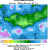
-
December 2018 Observations and Discussion
Hawkeye replied to Minny_Weather's topic in East of the Rockies
Much of the snow down south, from nw Texas through MO/AR, has really diminished on recent model runs. All those GFS runs throwing a bunch of snow up into KS/MO were very wrong. -
I woke up to a couple tenths of an inch of snow, just enough to briefly dust the landscape.
-
December 2018 Observations and Discussion
Hawkeye replied to Minny_Weather's topic in East of the Rockies
I keep checking the models, but they keep showing a whole lot of nada through mid month. Those of us who missed our chance at something good will have to wait a while longer. -
Light snow/flurries through the day added a small amount to my precip total, putting my storm total at 0.86".
-
Yeah, it's not looking good for our area. The next big storm is going to miss well south and there's nothing on the models beyond that.

