Hawkeye
-
Posts
7152 -
Joined
-
Last visited
-
Days Won
17
Everything posted by Hawkeye
-
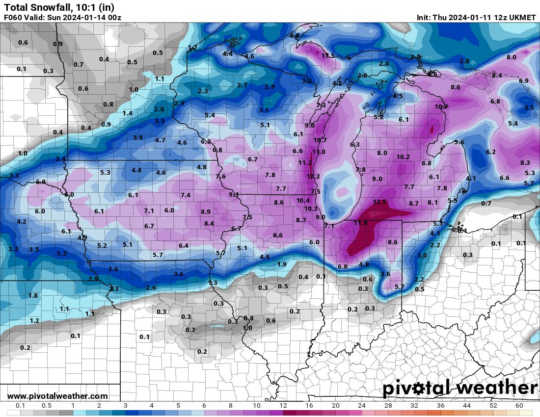
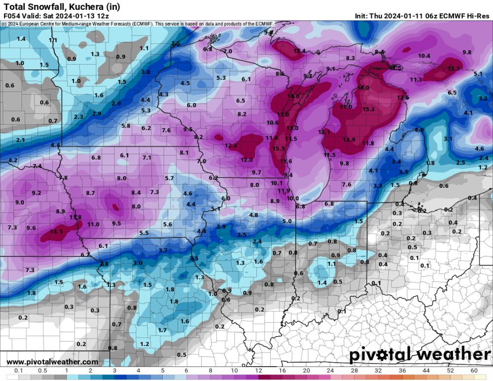
The 500 mb energy that is producing this system is pretty messy. The models have struggled with the details. For the last few days it looked like southwest through all of northern Iowa would get hit hard. However, it is southern Iowa that got hit hard while northern Iowa appears to be busting badly.
-
I am at about 2.6" now, a pretty underwhelming first half of the storm. My two small snow boards only have 1" on them, so the wind is clearly blowing the snow off the boards. My main board, with the backstop built up around the south side, has 2.6". The snow has been a bit light so far, but it's getting heavier.
-
I have three snow boards out. Because snow tends to blow off my boards, I backstopped my main board by adding an incline around its south side, hoping that would help keep snow on the board a bit better. The other two boards are just sitting on a flat area. The main board has 1.7", the other boards have 1.0" and <0.5".
-
Maybe 1.5" here. The model trend was correct, unfortunately. Southern Iowa got hit hard overnight, with 5-6" totals from Omaha to Des Moines to Ottumwa to the Quad Cities, but the snow really crapped out as it headed north toward highway 30. At this point I'm just hoping for 5" total.
-
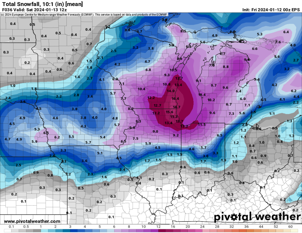
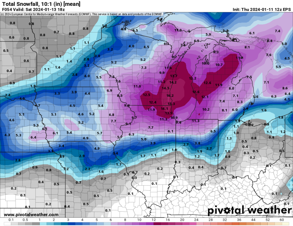
Sheesh... after greatly improving for the previous two runs, the Euro just totally pulled the rug out from under Cedar Rapids/Iowa City. It basically has the storm splitting around us now. The UK did the same thing tonight. Now the 06z NAMs have both cut us way down. The EPS mean also just cratered for Iowa. I'm suddenly very worried about this.
-
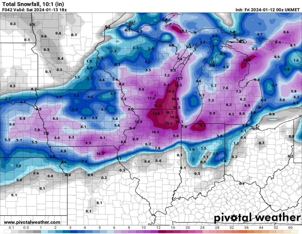
The UK just dropped a turd on Iowa.
-
Another trend is for tonight's surge of good snow to mostly veer east of my area, with northern Illinois getting the heavy stuff. I may only get an inch or two through morning.
-
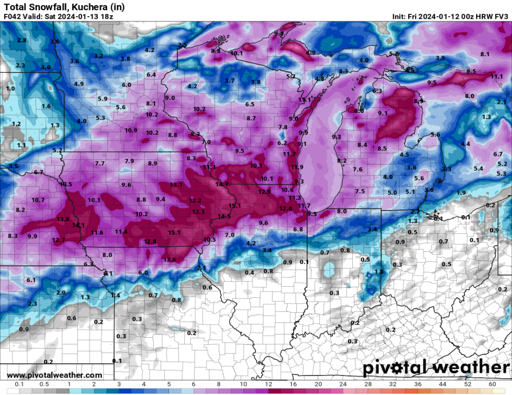
FV3
-
The trend had been great for my area, but the the 00 NAMs went the other way... . The 3k NAM has really dried out for the Omaha to northern Iowa corridor.
-
Today, the Euro has shown a significant trend toward increasing snow across eastern Iowa. The 06z run had a dry hole over us. 12z filled the hole. 18z is even wetter. As with a few other models, there is a trend toward extending the low farther west and blowing up heavier precip over east-central/southeast Iowa.
-
-
The models that are elongating it farther west are the ones that dump more snow here, so I hope they are correct.
-
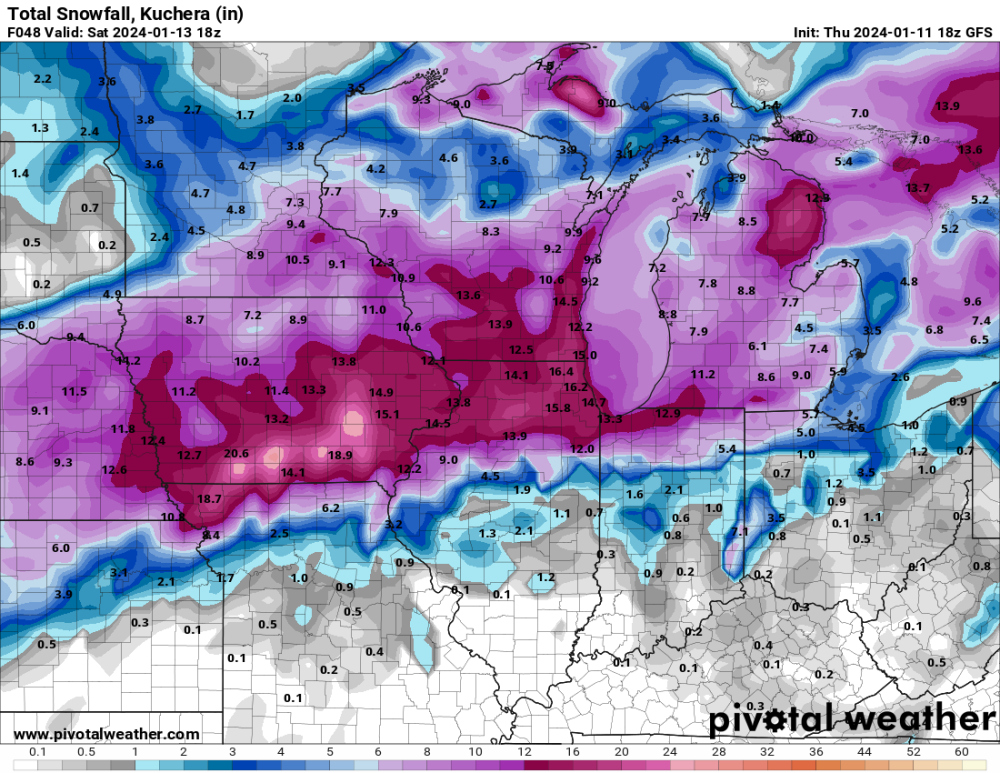
lol at the GFS. There is no way this verifies for southern Iowa. I'm hoping we can get half of that.
-
EPS
-
3kNAM actually has less in Cedar Rapids compared to the 12z run, half as much as the regular NAM. There is still plenty of noise.
-
It's difficult to believe any particular run when we are seeing changes like this from one run to the next.
-
I'm not sure how much we'll get... probably something in the 4-8 range.
-
See, this is very different from some other models that show the heaviest band through Waterloo, with only a few inches over southeast Iowa where the RAP is heaviest. I really want to see some model convergence.
-
UK

-
I'm concerned a bit about southeast/east-central Iowa. There is definitely a hint in the models that wave #1 will drop its heaviest snow northwest of us and then wave #2 will mostly miss northeast, leaving a relative dry pocket across this area. The 06z Euro is showing exactly this. I'm not buying the GFS, which is very aggressive for southeast Iowa and a southeast outlier.
-
Thursday morning's models won't be contaminated by this evening's snow burst.
-

January 2024 Observations and Discussion
Hawkeye replied to Minny_Weather's topic in East of the Rockies
My total is 2.6". It's too bad that super heavy snow was so brief. For about five minutes, it may have been snowing at 5"/hr. -
January 2024 Observations and Discussion
Hawkeye replied to Minny_Weather's topic in East of the Rockies
I just received 1" of snow in 15 minutes. This was an incredible burst.- 1054 replies
-
- 12
-

-

-
January 2024 Observations and Discussion
Hawkeye replied to Minny_Weather's topic in East of the Rockies
This is the heaviest snow of the season. Not large flakes, but extremely dense. Even the house across the street is foggy.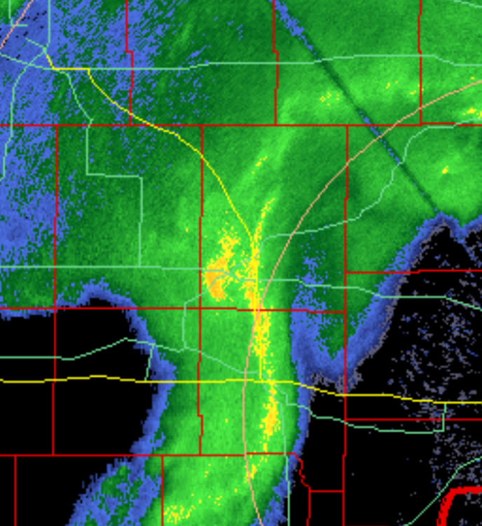
-
January 2024 Observations and Discussion
Hawkeye replied to Minny_Weather's topic in East of the Rockies
It's already snowing pretty good here, but there is what looks to be a very heavy pocket about to move over Cedar Rapids. There is even a dot of orange on the radar. It should really rip hard.