


Hawkeye
-
Posts
7150 -
Joined
-
Last visited
-
Days Won
17
Everything posted by Hawkeye
-
Boy, this is quite the storm. It has been snowing for over 24 hours. Current radar shows one final band of snow that is strengthening as it passes through Cedar Rapids.
-
Once the snow starts drifting, spotter reports start diverging. Some people measure in driftier areas while some measure in blowier areas (me). Once again, I will come up short of 12".
-
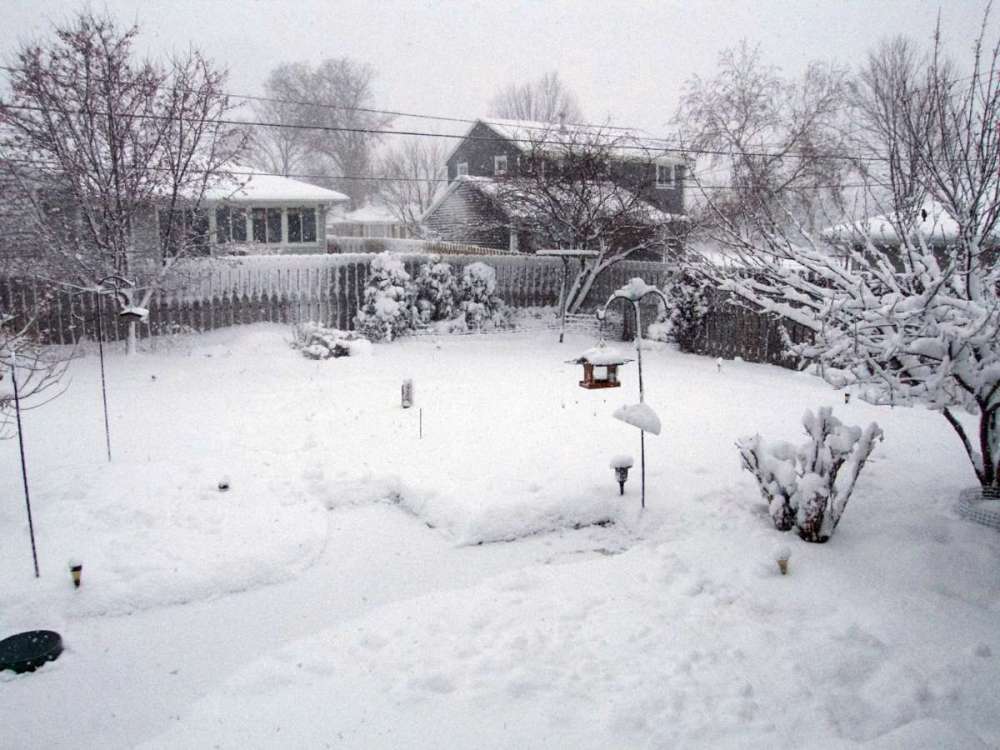
I'm up to 10.5". There is a lot of snow. I've never seen the house totally plastered with snow like this.
-
I am falling behind other spotters in the area due to blowing and drifting. Snow gets blown off my board, despite the fact my backyard is enclosed by a fence. I do live at the south edge of an open field, so late in these storms the north wind howls across the field and hurts my ability to measure accurately. Even though it has been ripping for the last few hours, I've only managed to accumulate one inch on my board. My total is 9.7". Other spotters are now reporting 11-12.5".
-
Radar still looks great. A moderate to heavy band continues to be parked over Cedar Rapids.
-
9.2" now. The patio actually accumulated another inch last hour, but, perhaps due to compaction, the snow board only rose another 0.6".
-
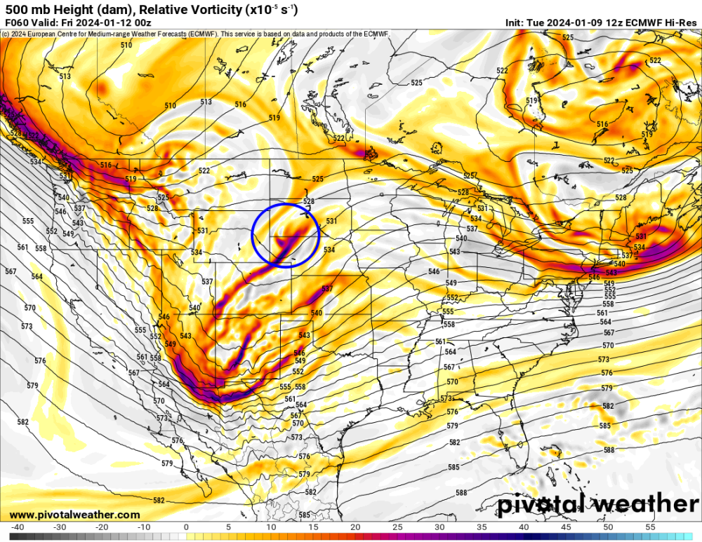
For Iowa, this piece of energy appears to be important. The main, southern, energy is going to swing east and northeast around that blue-circled energy. Plus, that energy acts to pull moisture back into Iowa. Iowa needs that energy to be stronger and hold farther west. The GFS is shooting it eastward more, so the main energy can't cut until farther east.
-
Yeah, you did well. I was not expecting Waterloo to do nearly that well.
-
1.3" in the last hour, up to 8.6". Conditions have change dramatically over the last hour. The snow has dried a bit and the wind has risen quite a bit, really blowing now, much more like a typical winter storm.
-
-
I just measured 7.3". Moderate to heavy bands are expanding over the Cedar Rapids area.
-
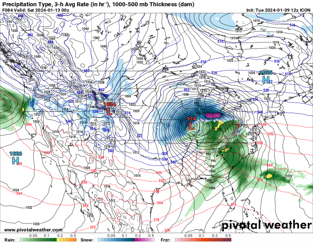
The GDPS trended toward the GFS, not something I want to see.
-
ICON
-
Yeah, a yellow band is about to move over Homestead. I am up to 6 inches. The snow has been a bit lighter than expected so far this morning, with too many breaks, but it's dumping now.
-

January 2024 Observations and Discussion
Hawkeye replied to Minny_Weather's topic in East of the Rockies
It appears it may be brutally cold for the Iowa caucuses next Monday evening. The Euro is showing a temp across the state of -10F and a wind chill of nearly -30F. -
The Des Moines/Ames area appears to be the overnight winner, with reports of 8-10".
-
I'm at 4.8" this morning, waiting for the defo zone to solidify. The ratio so far is 8.7 to 1. With another 12 hours to go, I should get another 4-6".
-
I'm up to 3.1".
-
I already have 2.1 inches, so it is accumulating efficiently.
-
18z Euro... continues to shift the heaviest band southeast.

-
Models continue to fade southeast.
-
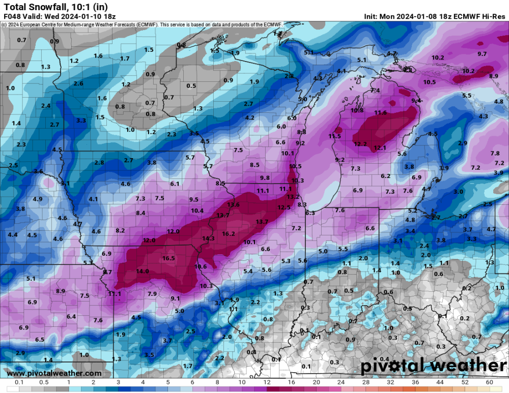
So even if we get a solid 10:1 ratio, the GFS says Cedar Rapids only gets 8". Meanwhile, DVN says 11-16". That just seems way overdone. I'm still only expecting 6-8". Tomorrow's wind will certainly not help ratios. I ALWAYS get garbage ratios when the snow is blows around and compacts in my yard.
-
So now it's 11-16" in Cedar Rapids? Jeez. I'm still going with 6-8". It will be interesting to see what the average ratios are. The models are consistently showing ratios in the good snow band only around 7 to 1, pretty awful. The NWS graphics suggest a ratio above 10 to 1.
-
The latest Euro is a bit messy with the energy, so it's kinda strung out until farther east.
-
12z GDPS slid a bit farther east, similar to the GFS.


