

Brian_in_Leavenworth
-
Posts
3545 -
Joined
-
Last visited
-
Days Won
7
Posts posted by Brian_in_Leavenworth
-
-
1 hour ago, SpaceRace22 said:
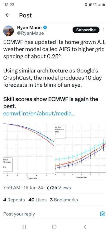
Yeah, the AIFS. It's available here: https://charts.ecmwf.int/?facets={"Product type"%3A["Experimental%3A AIFS"]}
https://www.ecmwf.int/en/about/media-centre/aifs-blog/2024/first-update-aifs
-
 3
3
-
-
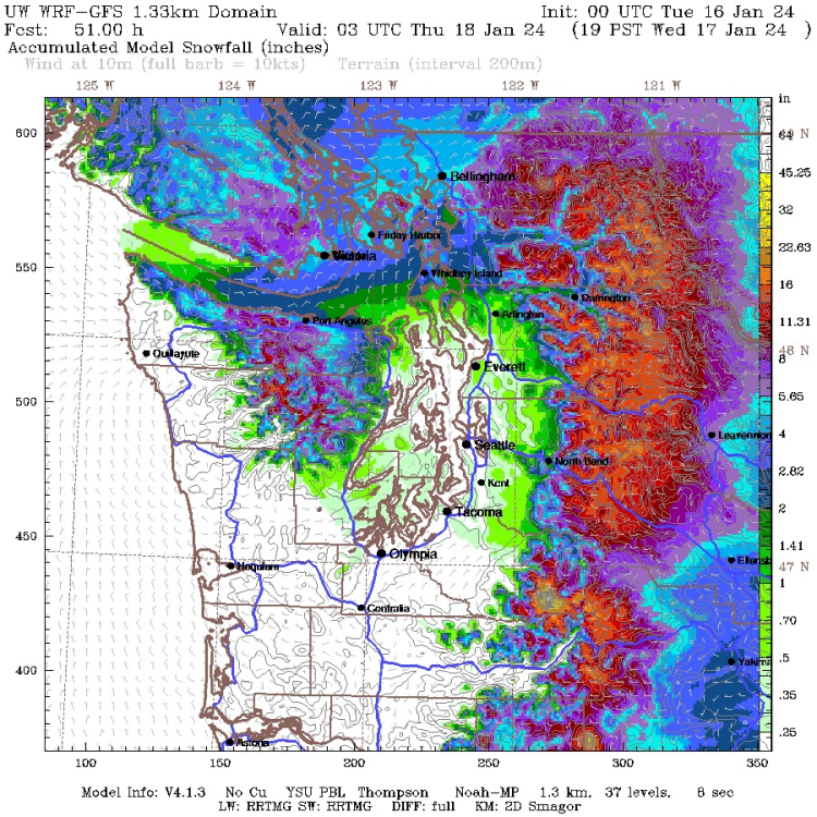
Here's the high resolution model through late Wednesday
-
3
-
 1
1
-
-
8 minutes ago, Phishy Wx said:
either that or they're a lot smarter than a forum of armchair meteorologists model riding on the internet. I'd trust the degreed scientists on this one. I'm sure if something presents itself to change the forecast they will. didn't the NBM show basically nothing for the western lowlands south of the border?
I agree. Just a quick glance and a lot of the possible freezing rain happens with temps right at freezing, according to the map, but they might think the actual temps will be above freezing. Those temp maps are not a real high resolution map.
Still it needs to be watched closely.
-
2
-
-
45 minutes ago, KingstonWX said:
This would be EXCELLENT for me! Make it happen!
So a map that show Stevens Pass getting almost no snow and Skagit/Whatcom counties getting more than 10?
Yeah right.
-
 1
1
-
-
2 minutes ago, Brennan said:
Looks like it’ll be a wonderful time to be in Leavenworth.
Winter Storm watch for late Tuesday into Wednesday. Latest forecast has us in the 8-12 inch range.
-
2
-
 1
1
-
-
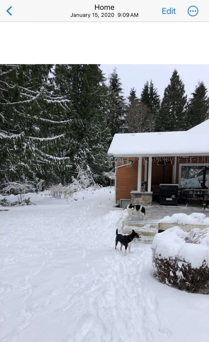
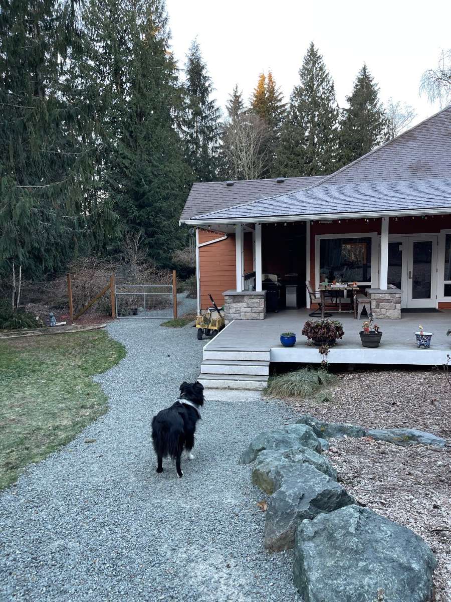
6 minutes ago, MossMan said:
I would take the first picture with temps in the upper 20’s over the second picture (this morning) with light frost on the roof and temps in the mid teens any day, All this one did was destroy my high traffic grass. Mud the rest of the winter now, yay!!
I will try hard not to be me for the rest of the day now lol.

I was disappointed in the 2/1/1989 event. Yes it got cold, one of the coldest events in Bellingham over the last 100 years. But hardly any snow. And within 5 or 6 days IIRC it was over. Temps back to normal.
Later on, in early March, we had a good snowstorm and that was way more enjoyable.
-
6
-
 1
1
-
-
19 minutes ago, Kayla said:
Need at least -20F or so.
This trick is probably safer.
-
 1
1
-
-
- Popular Post
- Popular Post
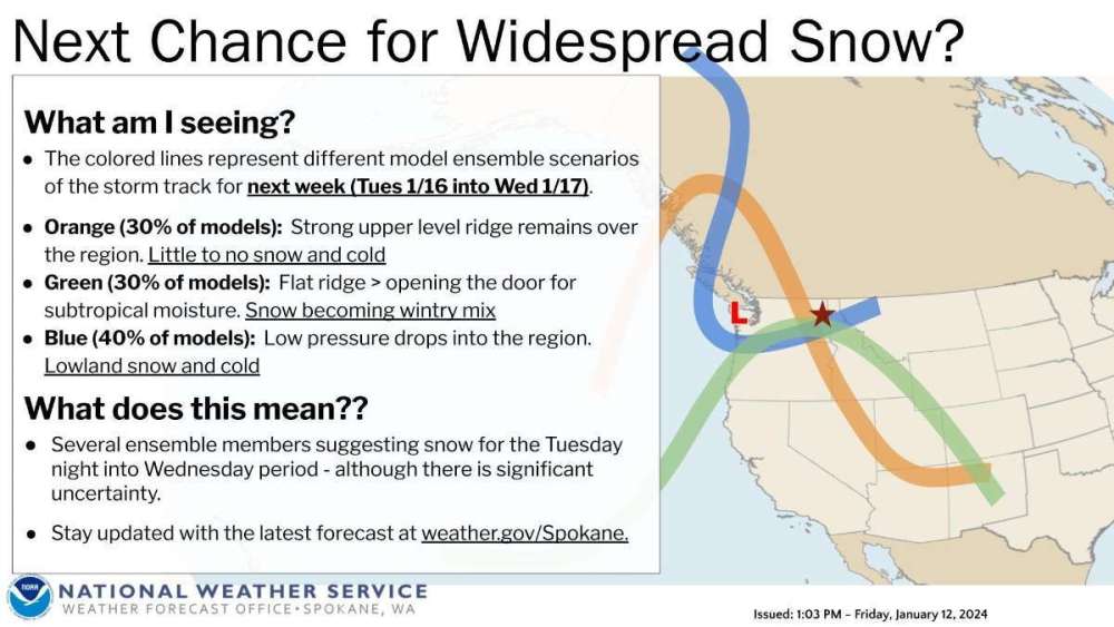
24 minutes ago, Cascadia_Wx said:I find it a little intriguing how many GEFS ensemble members want us to go arctic again around the 19th. Could just be noise, but worth watching.

I posted this earlier, but it's worth repeating. It's a graphic from NWS Spokane. Of course when they talk about snow they mean their forecast area. But it goes to show how the ensemble mean often doesn't tell the story.
-
10
-
-
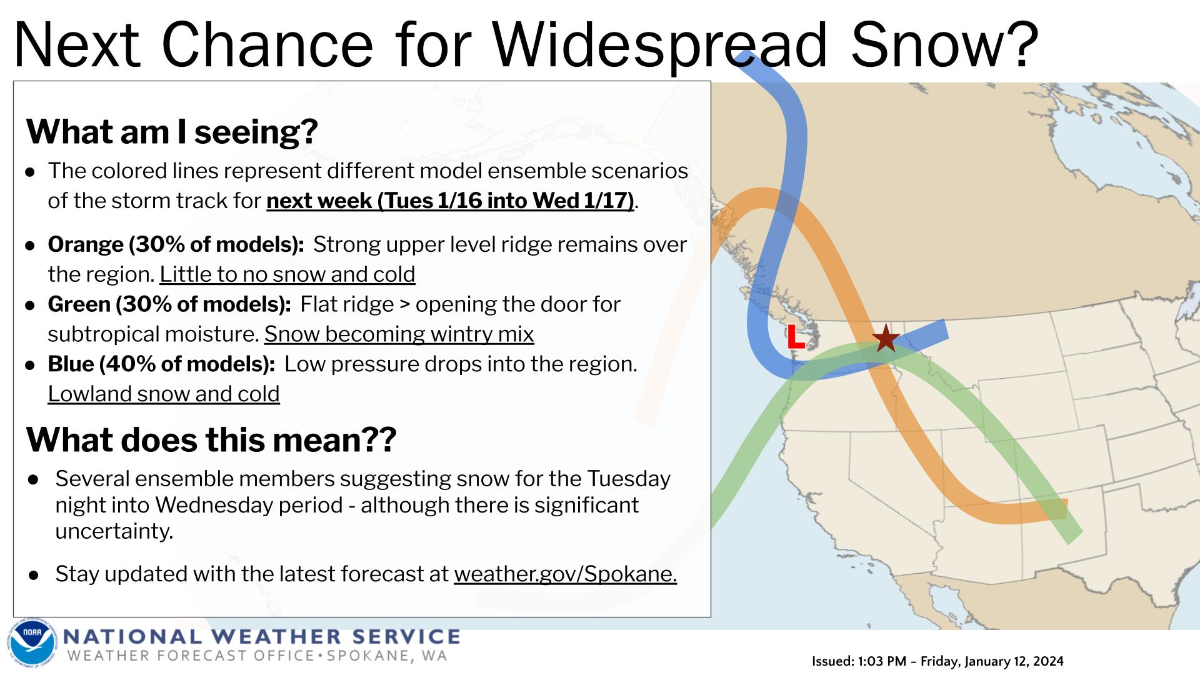
Of course the focus is on the upcoming event, but looking ahead a bit, next week has a lot of uncertainty. We all see the EPS or the GEFS, but that is an average and not necessarily an actual solution.
NWS Spokane has a good graph illustrating the possibilities and the uncertainty. Keep in mind they of course forecast for Eastern WA and North Idaho, but the illustration is still helpful.

-
3
-
 1
1
-
-
6 minutes ago, TT-SEA said:
Can't wait. Lake effect? Hope the bands set up right over stadium.
I've heard the lake temperature is warmer than normal for this time of year, though that probably won't last long. But the warmer water temps will certainly help with the snowfall. Could be epic.
-
1
-
-
16 minutes ago, Dave said:
Chiefs vs Dolphins on Saturday evening. High of 5 for the day (probably about 0 for game time). -25 wind chill.
Steelers-Bills game Sunday will be near blizzard conditions, according to FFWeatherGuys
 We have an Extreme Weather event shaping up for Sunday's Steelers @ Bills 1pm game.
Near 30mph sustained winds with moderate-heavy snow will result in near-blizzard conditions for the duration of the game.
You don't see #NFL playoffs games in blizzards often.
-
6
-
1
-
1
-
-
1 minute ago, ShawniganLake said:
Hope is down to -1F so it is possible as that is the source for the air the eventually gets to Bellingham. I think Hope is likely to be near the bottom now so I’d bet Bellingham doesn’t go sub zero.
Maybe Friday night though, especially if the winds die down.
-
Speaking of mid next week, here is a good discussion from NWS Spokane regarding ensemble breakdown Keep in mind they forecast for Eastern WA and North Idaho
There are some discrepancies as we head into Tuesday and beyond.
The question becomes what happens to the ridge along the west
coast. Does the ridge axis move east a bit and protect us, or
will the axis remain along the coast and send waves down the
front side of the ridge into eastern WA and north ID? By
Wednesday there are 12% of the ensembles showing a deep trough
moving in from the north, but that 12% is all European models. 33%
keep the ridge strong, which is 90% of the GFS models. Then 36%
show a broad flatter ridge and 19% showing some northwest flow and
lower heights. Lots of potential scenarios. The basic idea is that
temperatures will continue to moderate up towards average, but
still be 5 to 9 degrees below average, and we will see an
increased chance of snow starting Tuesday afternoon and continuing
through the remainder of the forecast period.
-
1
-
-
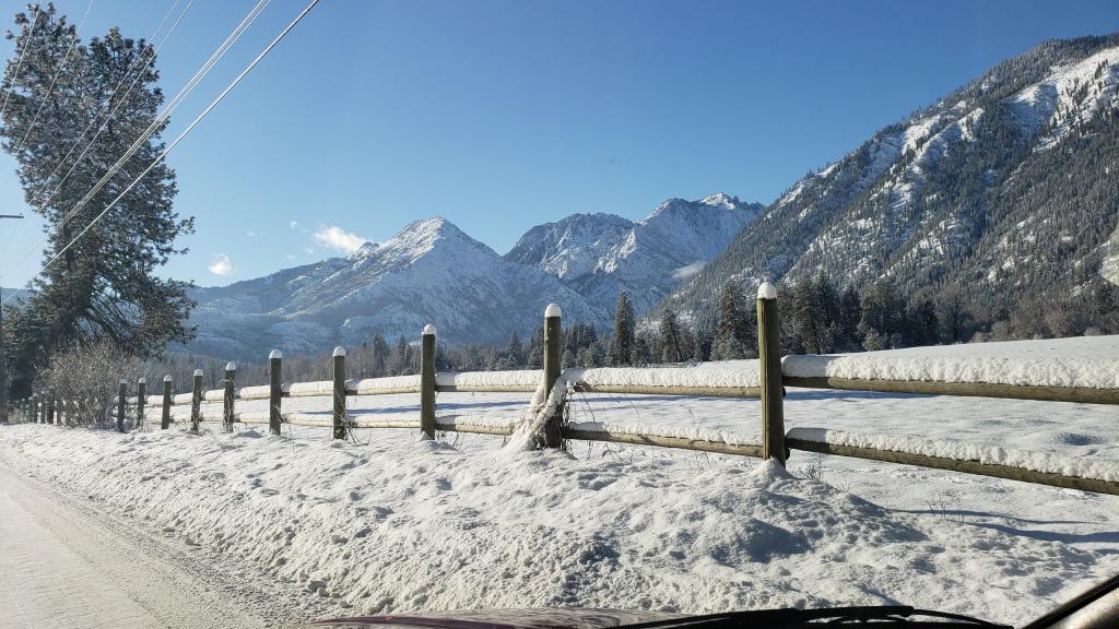
6" and still snowing lightly in Leavenworth. 20 degrees currently.
We had 9" Monday night and so far this winter between 45 and 50 inches.
-
6
-
-
11 minutes ago, Christensen87 said:
Not CFS…

Good. You know it's run 4x daily, and is usually different each time. And supposedly it is being discontinued soon.
-
2
-
-
5 minutes ago, Front Ranger said:
That CZ looks healthier than any model showed.
Yes. It has spilled over into and past Leavenworth all the way to Wenatchee. We've had heavy snow for awhile, and temps are starting to drop into the 20s.
-
2
-
-
5 minutes ago, Sunriver Snow Zone said:
I have a question for everyone here, why do you like snow so much? I feel like everyone here likes snow, but some of them I doubt do anything more than look at it, but yet they still root for it. Personally I root for it because it looks nice, feels great, skiing/sledding/snowshoeing is fun, it's fun for kids, and I enjoy using my snow blower.
All of the above. And I love watching the snow fall, and the quietness after a snowstorm. Also the way that the evergreens are painted with snow the morning after a snowstorm. The deep blue skies above and the painted evergreen trees and mountains is a combination that can't be beat.
I'm someone who really loves all the seasons. I love the fall colors, sunny Summer days with occasional (wet) thunderstorms, and seeing the green grass and flowers come back after the snow has melted. Though the time between the snow melting (usually in March) and the colors coming back is my least favorite time.
-
7
-
-
Just now, Brian_in_Leavenworth said:
Not that we should believe the GFS literally, but if the temps are that cold, qpf ratios would be higher than it normally is for a Seattle snow.
-
1
-
-
1 minute ago, awright-31 said:
Careful, don't get too excited. Those snow totals are way overdone, the GFS always does that. 6-10" way more realistic on the high end of things. Maybe a foot in a few spots.
Not that we should believe the GFS literally, but if the temps are that cold, qpf would be higher than it normally is for a Seattle snow.
-
1
-
-
1 minute ago, ShawniganLake said:
A question for our stats guys. Let’s say Portland scores big. 8-12” this week. Have we ever had a winter where Portland got 12” and Bellingham basically gets skunked?
Don't know about an entire winter, but for singular events, probably. Strong arctic fronts with strong winds will skunk Bellingham.
1989 is a classic example, and saw some of that with I think the 2nd arctic blast in December 1990.
Meanwhile areas south got a lot of snow.
-
23 minutes ago, Mid Valley Duck said:
I've heard from a NWS employee who shall remain anonymous, that while it is a great tool they are basically forced to forecast off of it. So situations like last February for Portland completely bust because they can't use their human touch on their official forecasts.
I remember a few years ago there was a news story about a proposal where forecasts were to be made at the national level, so that local mets would not be making the actual forecast, except when it is obvious it needs to be changed in the moment (I have seen that here in Leavenworth where it could have been rain or snow, and when it was snow, they made an adjustment in the forecast).
This sort of takes away local knowledge, though in the AFDs they sometimes talk about pattern recognition
I also wonder if this was pertaining not to the zone area forecasts, but the automated city forecasts. I have seen the automated city forecasts being completely different then the zone forecasts.
A few years ago we had a WSWarning, zone area forecast for 6-8 inches of snow with highs in the mid to upper 20s, but the Leavenworth city forecast was for rain and a high of 43. Zone forecast was right, city was wrong.
Don't know if it ever happened though
-
2
-
-
From what I've read, the NBM isn't simply taking every ensemble run and making a mean out of all of them. Nor does it "favor" one model over another or weigh one model over another.
It sounds like it weighs all of them, but instead of a simple mean, it takes into account all known biases and tendencies of each model and then blends it all in.
And over time it has improved, partly because models have improved, and partly because it better understands model tendencies and biases and better takes them into account
-
5
-
-
Interesting discussion from Pendleton NWS. Pretty technical, and I don't understand all of it. I am pretty much neutral in the Oregon vs Washington debate, since I get more snow than anyone in the forum from Washington or Oregon (A1Tahoe definitely gets more than all of us). I would love to see the northern solution, but would be happy for the Oregon posters if it goes there. Anyway . . .
Guidance is in good agreement with the active pattern through the
weekend before a respite arrives early in the workweek, but
differences in the upper trough's strength and path arise regarding
the Friday and Saturday systems. The GFS is weaker and more north
for both systems, which pushes Friday's system more north into
Washington and Saturday's system right through the Pacific
Northwest. This provides a wetter, warmer, and windier outcome with
the GFS than the ECWMF.
These discrepancies are visualized via the 500mb EOF Patterns, which show a 50-60% ensemble variance regarding strength and location of both synoptic features.

Analyzing both the cluster 500 mb heights and cluster phase space provides additional confidence in the GFS scenario as more ensemble members align with the GFS outcome and the deterministic solution is better represented by the ensemble mean. Thus, the NBM was utilized through the extended period to provide an appropriately weighted scenario, with the expectation of a slight trend to wetter/snowier conditions and warmer temperatures over future runs
-
2
-
 1
1
-
 1
1
-


January Weather In The PNW 2024 (Part III) - The Warming Shot
in West of the Rockies
Posted
You're right. Actually would be better if it was snow then freezing rain. I have seen that where I live. Had a decent amount of freezing rain around Christmas last year, but it fell on snow and wasn't a big deal. But having ice under the snow isn't good at all.