

Brian_in_Leavenworth
-
Posts
3545 -
Joined
-
Last visited
-
Days Won
7
Everything posted by Brian_in_Leavenworth
-

December 2019 Weather Discussion for the PNW
Brian_in_Leavenworth replied to Timmy Supercell's topic in West of the Rockies
Improvements in the longer range GFS. At least it doesn't show ridging over us the entire time. Too bad it is the longer range, but its a start toward a more active pattern, hopefully. Looks like all the models are starting to show ridging way up north in Alaska/Northern Canada with maybe backdoor cold and overall a bit more active pattern for us. -
December 2019 Weather Discussion for the PNW
Brian_in_Leavenworth replied to Timmy Supercell's topic in West of the Rockies
DJ meant this one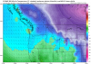
-
December 2019 Weather Discussion for the PNW
Brian_in_Leavenworth replied to Timmy Supercell's topic in West of the Rockies
Though not arctic, day 10 on the Euro shows decently cool temps in Eastrrn WA and cold temps in BC. First time in the last few days that it has shown temps this cool. If course it didnt go out that far in previous runs.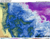
-
December 2019 Weather Discussion for the PNW
Brian_in_Leavenworth replied to Timmy Supercell's topic in West of the Rockies
It seems like both the Euro and the Canadian were similar to their previous runs, except the transition to westerlies was delayed a day or so. But that Euro does look interesting beyond just the westerlies showing up. -
December 2019 Weather Discussion for the PNW
Brian_in_Leavenworth replied to Timmy Supercell's topic in West of the Rockies
I get using the analogs for a predicted upcoming pattern, like the 6-10 or 8-14 day range, but to use it to say "that analog from 19xx was 3 weeks before a great arctic outbreak, so that means we may get a repeat" is totally meaningless IMO. -
December 2019 Weather Discussion for the PNW
Brian_in_Leavenworth replied to Timmy Supercell's topic in West of the Rockies
The thing I always have thought about the analogs is that, even if what is shows was EXACTLY the way it was in, say, December 1949, I doubt that the weather would play out exactly like it would through January 1950. So I really don't take much stock in them. Yes, things like ENSO and other indices can tell us the likelihood of how a winter will play out, but sometimes I see an analog on the CPC of something from 1949, and a few people will get excited because of January 1950. Or some other analog from a time that ended up being good several weeks later. I really doubt there has ever been two winters that played out pretty much the same from mid November through early March. -
December 2019 Weather Discussion for the PNW
Brian_in_Leavenworth replied to Timmy Supercell's topic in West of the Rockies
Thanks for sharing that. I will also check twitter, sometimes Ventrice or Noll tweet about it. -
December 2019 Weather Discussion for the PNW
Brian_in_Leavenworth replied to Timmy Supercell's topic in West of the Rockies
What kind of a pattern is it showing before then? -
December 2019 Weather Discussion for the PNW
Brian_in_Leavenworth replied to Timmy Supercell's topic in West of the Rockies
Well put. Without irrigation, they can't grow anything. And it is not just the orchardists and farmers, many people get irrigation water for their lawns, their fruit trees in their yards, etc. And, contrary to what many people think, the real reason why big dams like the Grand Coulee were built is for irrigation, not hydro electricity, though of course that is a welcome byproduct of the dams that give us the cheapest electricity in the U.S. -
December 2019 Weather Discussion for the PNW
Brian_in_Leavenworth replied to Timmy Supercell's topic in West of the Rockies
Yes, it looks very much like last nights Euro and the EPS. WAY different than the GFS. -
December 2019 Weather Discussion for the PNW
Brian_in_Leavenworth replied to Timmy Supercell's topic in West of the Rockies
Ensemble mean is also ridgy too. -
December 2019 Weather Discussion for the PNW
Brian_in_Leavenworth replied to Timmy Supercell's topic in West of the Rockies
My wife, who is from Toronto, says the exact same thing. Even at our hottest, you can at least go outside for awhile, and it is still fairly comfortable in the shade. In more humid areas, it is like stepping into a sauna with all your clothes on. And I still remember being in Florida a few years ago, and the first morning we were there, temps were still in the mid 70's, and any wet towels that you hung out overnight were still damp. -
December 2019 Weather Discussion for the PNW
Brian_in_Leavenworth replied to Timmy Supercell's topic in West of the Rockies
The only difference that I see is that the EPS is a bit quicker, consistent with the timing of previous EPS runs. -
December 2019 Weather Discussion for the PNW
Brian_in_Leavenworth replied to Timmy Supercell's topic in West of the Rockies
It does seem like the EPS has been much more consistent than the operational. And it has been consistent with the timing of that too. -
December 2019 Weather Discussion for the PNW
Brian_in_Leavenworth replied to Timmy Supercell's topic in West of the Rockies
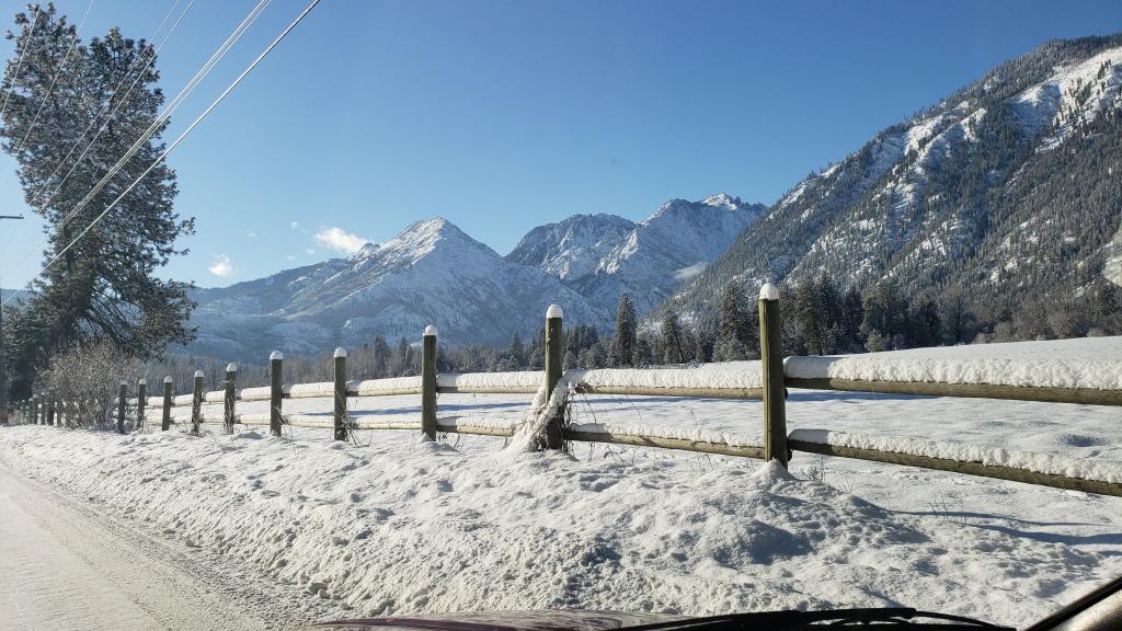
Light snow here, as expected. They are calling for 1-2 inches, which seems about right. Pretty small snow for us, but nice to look at. -
November 2019 Weather Discussion for the PNW
Brian_in_Leavenworth replied to TigerWoodsLibido's topic in West of the Rockies
It has been a little inconsistent in the 8-10 day range the last few runs. And definitely different not only from the 12Zz and the recent EPS but also the GFS and Canadian and their ensembles. Unless it is picking up on something new before the others. -
November 2019 Weather Discussion for the PNW
Brian_in_Leavenworth replied to TigerWoodsLibido's topic in West of the Rockies
Tonights QPF on the Euro: Spreads further into North Central WA, just a bit more precip there, and a tiny bit less elsewhere. Minor differences in the overall scheme of things. The 12Z Euro from today: -
November 2019 Weather Discussion for the PNW
Brian_in_Leavenworth replied to TigerWoodsLibido's topic in West of the Rockies
Canadian looking very similar to the Euro at about the same hour. Euro at 12Z Sunday morning (Dec. 7) Canadian at the same time -
November 2019 Weather Discussion for the PNW
Brian_in_Leavenworth replied to TigerWoodsLibido's topic in West of the Rockies
Not disagreeing with you at all. It was such a blanket statement that Mark probably didnt want interpreted as a forecast. And it is true, the first cold snap could be the coldest one, or it could just be the first of many. And you can say that every year without it meaning anything. -
November 2019 Weather Discussion for the PNW
Brian_in_Leavenworth replied to TigerWoodsLibido's topic in West of the Rockies
The thing is you could say that every winter the first time a mini cold snap comes. Mark isn't usually one to give winter predictions anyway. -
November 2019 Weather Discussion for the PNW
Brian_in_Leavenworth replied to TigerWoodsLibido's topic in West of the Rockies
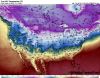
Here is the EPS hour 312, courtesy of Ventrice. Looks wet. Wondering what it showed after that. It looks to be at least a bit different than what it had been showing.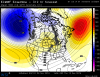
-
November 2019 Weather Discussion for the PNW
Brian_in_Leavenworth replied to TigerWoodsLibido's topic in West of the Rockies
It worked for me. I asked the computer to use Windows Media Player, and it worked. Hoping to see that kind of snow soon, thanks for showing this. -
November 2019 Weather Discussion for the PNW
Brian_in_Leavenworth replied to TigerWoodsLibido's topic in West of the Rockies
I think the PNW was under a death ridge that Thanksgiving. I do remember the weather and wishing I could go through a storm like that. As long as I were at home. -
November 2019 Weather Discussion for the PNW
Brian_in_Leavenworth replied to TigerWoodsLibido's topic in West of the Rockies
Could be worse. You could meet a shower curtain ring salesman. -
November 2019 Weather Discussion for the PNW
Brian_in_Leavenworth replied to TigerWoodsLibido's topic in West of the Rockies
Yeah, more like the previous couple of EPS's. One of the few times that the EPS looks a fair amount different than the operational. Not 180 degrees difference, but a bit more noticeable than usual.


