

Brian_in_Leavenworth
-
Posts
3545 -
Joined
-
Last visited
-
Days Won
7
Everything posted by Brian_in_Leavenworth
-

November 2019 Weather Discussion for the PNW
Brian_in_Leavenworth replied to TigerWoodsLibido's topic in West of the Rockies
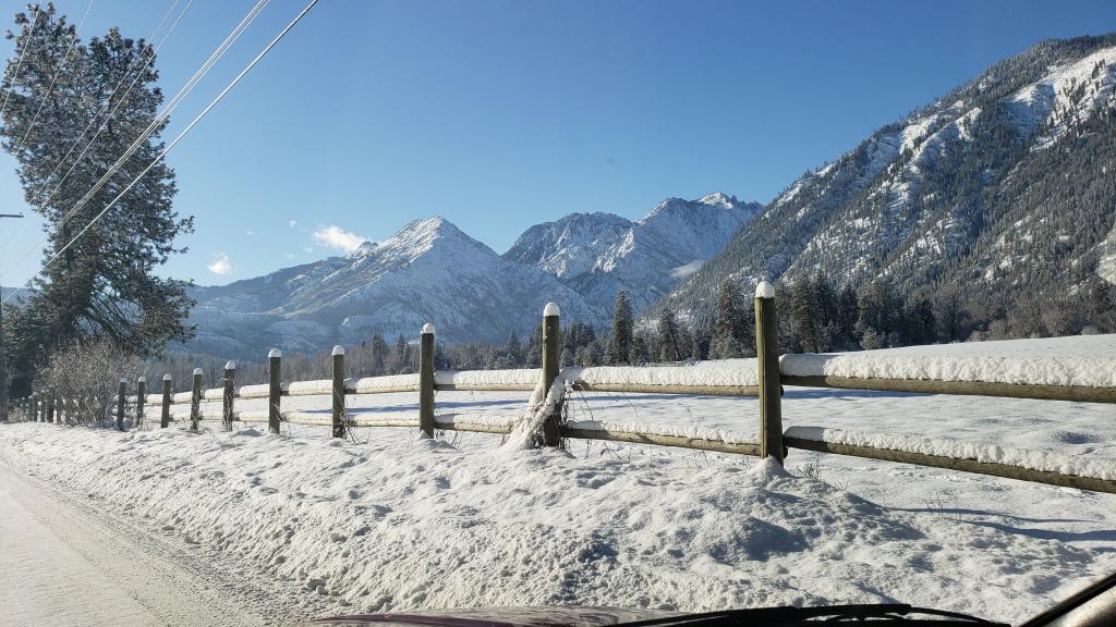
Perhaps a bit of convergence, but 100% sure it is upslope. I read the Spokane AFD and they talk about it. That is why I am getting snow, and if you look at the radar that I am seeing, it is Easterly flow. NWS calling for an inch of snow for Stevens Pass and 3-5 for Leavenworth, as the band of snow weakens as heads West toward Steven's. We see this a lot around here with upslope flow. -
November 2019 Weather Discussion for the PNW
Brian_in_Leavenworth replied to TigerWoodsLibido's topic in West of the Rockies
Thanks for the heads up. Will tell people around here. We are supposed to get 2-4 inches here today. More than originally forecast. -
November 2019 Weather Discussion for the PNW
Brian_in_Leavenworth replied to TigerWoodsLibido's topic in West of the Rockies
Actually not a convergence zone. It is upslope snow caused by easterly winds from the low to the South. Which is why I am supposed to get 2-4 inches of snow today. Probably fairly light snow considering that it is upslope snow and not a convergence zone. But hopefully they have gotten a bunch for skiers, but doubtful. One of the few times I am forecasted to get more snow than Stevens. Currently snowing lightly here. -
November 2019 Weather Discussion for the PNW
Brian_in_Leavenworth replied to TigerWoodsLibido's topic in West of the Rockies
Yeah, the pineapple Express solution is gone, more of a westerly flow instead of southwest. Gulf if Alaska trough not digging as far South as other runs. -
November 2019 Weather Discussion for the PNW
Brian_in_Leavenworth replied to TigerWoodsLibido's topic in West of the Rockies
Not surprisingly, the EPS is similar to the operational at day 10 (when is it ever way different than the operational?) -
November 2019 Weather Discussion for the PNW
Brian_in_Leavenworth replied to TigerWoodsLibido's topic in West of the Rockies
I would be happy with this, and so would skiers. -
November 2019 Weather Discussion for the PNW
Brian_in_Leavenworth replied to TigerWoodsLibido's topic in West of the Rockies
You posted that at the same time I was making the same point, so sorry for duplicating! -
November 2019 Weather Discussion for the PNW
Brian_in_Leavenworth replied to TigerWoodsLibido's topic in West of the Rockies
If experts can't agree about the blob, I sure as heck don't have an opinion. However, the argument that people like Cliff Mass make is NOT that it drives the pattern. They argue that the pattern is the same, BUT it warms the systems that come in and increase the humidity, since of course warmer air can hold more water. And it led to warmer overnight low temps than what would be expected. I do remember that winter the NWS in Spokane was continually forecasting temps that ended up being colder than what actually occured. After awhile, they begin to say that the warmer waters were making the systems a bit warmer than what models were advertising and what their experience with these weather patterns was telling them. -
November 2019 Weather Discussion for the PNW
Brian_in_Leavenworth replied to TigerWoodsLibido's topic in West of the Rockies
Looks like the GFS is showing a pineapple express in the clown range.
-
November 2019 Weather Discussion for the PNW
Brian_in_Leavenworth replied to TigerWoodsLibido's topic in West of the Rockies
Michael Ventrice @MJVentrice And the minor Stratospheric Warming Event, driven by a displacement of the Stratospheric Polar Vortex off it's axis, is now taking place. Michael Ventrice @MJVentrice One CFSv2 member highlights a 'Major' Sudden Stratospheric Warming Event during the month of December, where the bulk of the distribution is 'Minor'.
-
November 2019 Weather Discussion for the PNW
Brian_in_Leavenworth replied to TigerWoodsLibido's topic in West of the Rockies
Yes, once Summer hits we are pretty dry no matter what, but a low snowpack means fire season can start a lot sooner. There was a bad fire in June in Wenatchee that destroyed dozens of homes, and that was a really early fire for our area. And that was after a season with a very low snow pack. -
November 2019 Weather Discussion for the PNW
Brian_in_Leavenworth replied to TigerWoodsLibido's topic in West of the Rockies
Certainly what happens in Summer matters more, but if you start off with dry soil in March in the mountains because what little snow there was has melted, it can lead to a longer wildfire season. We have seen that here time after time. -
November 2019 Weather Discussion for the PNW
Brian_in_Leavenworth replied to TigerWoodsLibido's topic in West of the Rockies
Warm and wet. At least the mountains would have snow. A really dry winter could end up leading to disastrous wildfires, endless smoke, and water rationing next Summer. No thanks. Warm and wet is the lesser of two evils. -
November 2019 Weather Discussion for the PNW
Brian_in_Leavenworth replied to TigerWoodsLibido's topic in West of the Rockies
EPS about the same as the operational in the long run, and more similar to the GEFS than the Canadian Ensemble. -
November 2019 Weather Discussion for the PNW
Brian_in_Leavenworth replied to TigerWoodsLibido's topic in West of the Rockies
Some of that might be snow for South Puget Sound and Whatcom County/BC -
November 2019 Weather Discussion for the PNW
Brian_in_Leavenworth replied to TigerWoodsLibido's topic in West of the Rockies
Hopefully it is an outlier. And maybe the 12Z GFS is picking up on something that the Canadian has not yet. -
November 2019 Weather Discussion for the PNW
Brian_in_Leavenworth replied to TigerWoodsLibido's topic in West of the Rockies
A fairly strong signal in the Canadian ensembles for more boring weather. -
November 2019 Weather Discussion for the PNW
Brian_in_Leavenworth replied to TigerWoodsLibido's topic in West of the Rockies
I hope the GFS verifies, but I have my doubts. It is a big change from earlier runs, and way different than other models. So to me it looks like an outlier, but hopefully it is picking up on a real trend before the other models. -
November 2019 Weather Discussion for the PNW
Brian_in_Leavenworth replied to TigerWoodsLibido's topic in West of the Rockies
Agree 1000% -
November 2019 Weather Discussion for the PNW
Brian_in_Leavenworth replied to TigerWoodsLibido's topic in West of the Rockies
-
November 2019 Weather Discussion for the PNW
Brian_in_Leavenworth replied to TigerWoodsLibido's topic in West of the Rockies
Eastern WA definitely a bit colder at day 7, Western WA/OR about the same -
November 2019 Weather Discussion for the PNW
Brian_in_Leavenworth replied to TigerWoodsLibido's topic in West of the Rockies
Temps are pretty much the same though as the last few runs. -
November 2019 Weather Discussion for the PNW
Brian_in_Leavenworth replied to TigerWoodsLibido's topic in West of the Rockies
But 6 hours later it is making a run for the border, -
November 2019 Weather Discussion for the PNW
Brian_in_Leavenworth replied to TigerWoodsLibido's topic in West of the Rockies
Low quite a bit north on this run. I think it was stronger too. 0Z: 12Z -
November 2019 Weather Discussion for the PNW
Brian_in_Leavenworth replied to TigerWoodsLibido's topic in West of the Rockies
Seems with these changes in the mid term, the models may he in flux, so maybe we see more swings? Not that the clown range means much, but would trust them even less with some of the changes we are seeing.


