

Brian_in_Leavenworth
-
Posts
3545 -
Joined
-
Last visited
-
Days Won
7
Posts posted by Brian_in_Leavenworth
-
-
Jim Foreman still around? If not King 5 better get him out of retirement and get him on an overpass...STAT!
I posted this last week, but we have a lot of new members, ans besides, it is a classic
-
 3
3
-
-
I'd guess 2-4 degrees colder on average. Bigger difference for highs.
Phil would know, but I wonder if the arctic air itself would have been this cold a month ago. I don't just mean this year, with the timing of the SSW event, but in general, if it is in later January and into February that the arctic air is at its coldest.
-
Good twitter exchange someone had with Scott Sistek for those of you on the Eastside (east of Puget Sound)
- Replying to @ScottSKOMO
@ScottSKOMO are east winds going to eat all the snow in Snoqualmie and north bend?
1 reply 0 retweets 1 likeReply1Retweet1Like
One of the variables. Earlier models had stronger east winds and lower snow totals there but more recent trends haven't had as much and keep snow on Eastside too.
-
Ummm, what?
Thanks for sharing that. Good to see that the Kuchera ratios are available on that site, nobody ever posts those.
-
2
-
-
Keep posting model frames of all kinds and sharing this forum around. We are building a time capsule to what is already unprecedented in the model era and if the next couple weeks play out, something that rivals an all time great event.
When this is done, I'll spend a weekend and you your posts, maps, images, and obs to build a story from the first frame with a block to the last flake from the sky.
It would be interesting to go back to the January forum to just before the models starting locking in on this. IIRC, it had been showing something good, backed off on it for awhile, then suddenly starting showing something good and here we are.
-
2
-
-
Finally... a pattern that could deliver cold and snow!!! Just 9 days away!

Last night that same day looked like this:
-
Day 7 looks colder than it did with last nights run.
-
Kuchera ratio vs 10:1 ratio. Dont know which is more accurate in general.

-
If you change it to the kuchera ratio, totals change, in some places dramatically. My area does, as temps will be quite cold and snow ratios may be higher than 10:1. Yours may be too. The maps everyone looks at assumes 10:1.Ahhhh.
Still wrong.

-
Still cold at day 14
-
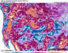
Jesus the BLI-YWL gradient looks to be 30-32 mb.
Albrecht pointed out that models usually overdo the gradiants. They had the last system progged at 29.9 mb, which was clearly overdone. Worth watching though. Like he said still windy and cold.
-
Can you explain this to me? That’s pretty crazy right?
The legendary 1989 blast was 24mb. The also legendary 1990 December blasts were 25mb. So this would be unbelievable.
-
It may be the 1989 storm that I'm thinking of. I wasn't quite 10 in 1990, so dates are likely confused. But I definitely remember being without power for a very long time. 10-year-old me thought that was pretty cool. Not so much for adult me.
1990 had two storms in December that I think were both more snowy than the 1989 Feb 1 arctic blast, and in 1990 led to a white Christmas. That was a much better event for North Sound as far as snow goes. But 1990 was pretty D**n windy too.
-
iFred's State of the Forum address later tonight should be a lot rosier than it looked a couple weeks ago.
Kevin Martin giving the rebuttal afterward.
-
2
-
-
I know it isn't too accurate, but the Weather Channel has multiple days of 3+ inches of snow for the PDX forecast, and for the first time that I've ever seen says "watching a potential winter storm" for Saturday.
It might be accurate, but rule of thumb is to not get your forecast from there. Mark Nelsen is a much better source for you. Recently the Weather Channel had Bellingham with higher temperatures than Seattle, which is ridiculous during cold weather situations. They also have Leavenworth sometimes with higher temperatures than Wenatchee, which doesn't happen during the winter time.
-
1
-
-
Truth be told, I could do without all of that. That 1990 storm brought down a solid mile of power poles across the only highway leaving town, and I'm not super interested in another brutally cold, dry storm like we got up here this past weekend.
I'm sure the rest of you all would enjoy an historic arctic blast like that, though.
So did the 1989 blast. And it was relatively dry in Whatcom County, especially Bellingham (I lived there at the time). I think there was a 100MPH wind gust with the 1989 event, and some areas had temps down to 0. I was surprised that this coming event was compared to the 1990 event as well as others.
-
Here is a guy those of you on twitter should ask to join this forum. This is really interesting!
1/6 #wawx Here are a Few Arctic outbreaks facts for Western Washington.
We hear a lot about the Frazier River Outflow winds, especially in Arctic outbreaks. This gap provides cold us air access to western Washington from the interior of British Columbia.2/6 The strength of these winds is dependent on the pressure difference or Gradient from Williams Lake, BC to Bellingham, WA (YWL-BLI). The stronger the gradient, the stronger the wind, and (usually) the stronger the arctic invasion into our region.
3/6 Any of you old timers that still live here remember the 1989 and 1990 arctic blasts. These are the record holders for strongest gradient YWL-BLI. 1990 had a whooping 25mb gradient, 1989 was at about 24mb. These were truly intense events.
4/6 Both of these events sent crippling snow/wind into the Puget Sound and have been the hallmark of arctic invasions at least in the last 60 years or so.
5/6 This much talked about setup on Friday/Saturday is showing the potential for gradients OVER 26mb. Also, Model agreement is as good as I can remember seeing.
6/6 As the high develops and retrogrades towards central British Columbia the strength of the high and resulting toughing over the Pac NW will change, so stay tuned.
-
2
-
-
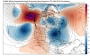
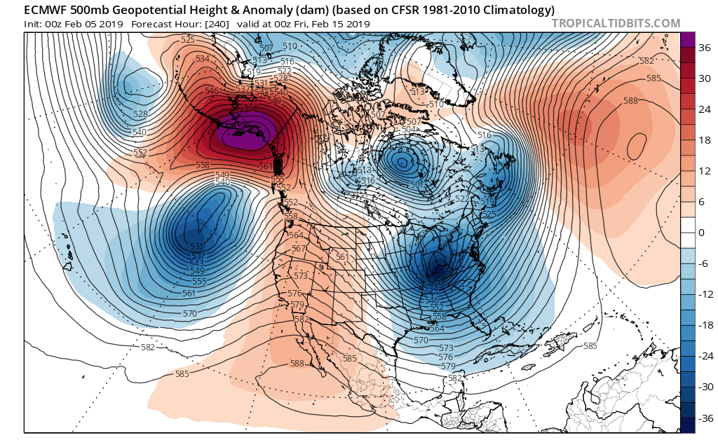
Persistent upper-level pattern with trough over Western US and ridge over SE US during the next 2-weeks.
Week 1 and Week 2 temperature anomalies (ECMWF EPS) are quite similar.

-
3
-
-
Uh oh, PDX NWS suggesting that snow is "likely" on Saturday and Sunday. This from the lates
This is why pro mets don't want to post here. Believing in jinxes and thinking that the people on here know more about the weather than they do is pretty insulting to them, I would imagine. Yes, they are wrong sometimes, but not as wrong as the amateurs around here are, and I have been on this forum since the beginning.
-
4
-
-
In-fuccking-sane.
Every frame of the EPS has looked basically the same for the last 2 weeks going out 15 days.
There is no variability. There is ALWAYS variability. I honestly cannot remember anything like this since I have been looking at weather models.
I see this kind of stability in the EPS all the time.
In the summer.
-
EPS at hour 240:

-
1
-
-
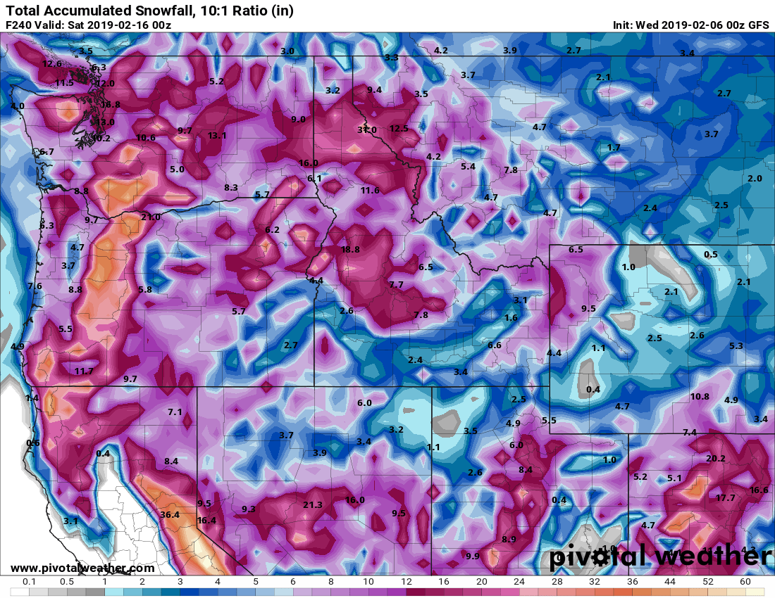
BTW, I mentioned this before, does anyone have any clue as to what the snow ratios would be for your area? It will be interesting if it is different that the usual 10:1. I know where I live since it is colder it can be higher.
-
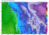
Euro snow totals - from Twitter
Pretty impressive that even areas pretty far out into the ocean are getting a lot of snow
-
Totals through 4AM Wednesday.

This assumes 10:1 ratios. Might be higher ratios in some colder areas.


February 2019 Weather in the Pacific Northwest - Part 1
in West of the Rockies
Posted
For perspective, I get a lot of snow here in Leavenworth. When we do end up with bigger snows, the progression of forecasts for our area usually follows the script of just a few inches 2-3 days in advance, and then they slowly up the totals as we get closer to the event. Of course sometimes we have smaller events of just an inch or two, but so many times the forecast in advance will say 1-3 inches day/1-2 night, then 2-4 day/1-3 night, then 3-5 day, 2-4 night, etc. Rarely will they call for 8-10 inches 3-4 days in advance.
Now for example, the AFD says 4-8 inches with maybe a foot. Talk about a large range, so they won't put up a forecast with the top amount at this time with that much uncertainty.