


gabel23
-
Posts
2291 -
Joined
-
Last visited
-
Days Won
5
Posts posted by gabel23
-
-
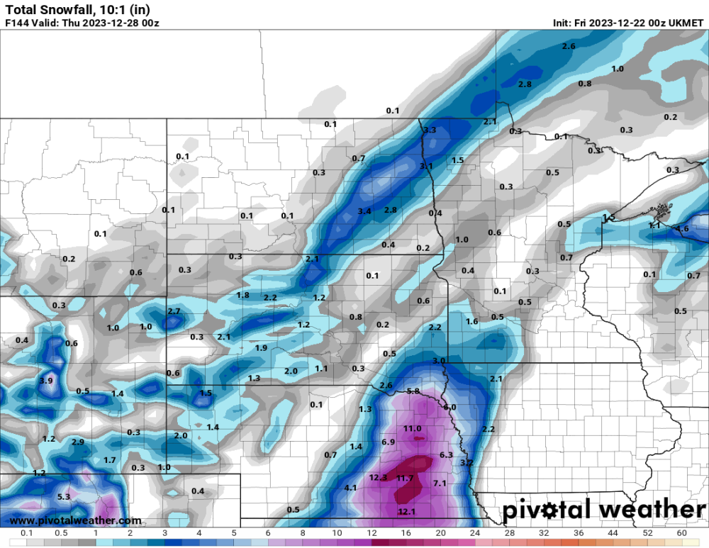
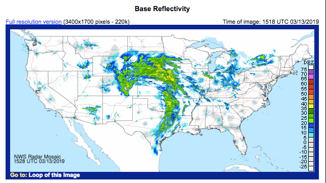
Looks like euro is holding true. I’m loving the trends tonight… The only problem is what happens to the area of low pressure? Looks like trends are slowing down and the euro has occlusion occurring over Iowa; that would bode well for heavy snow to the northwest. Gfs, cmc, and nam are also starting to show that as of tonight…
-
 4
4
-
-
12 minutes ago, Hawkeye said:
The 00z UK moved the heavy rain into western Iowa and eastern Nebraska, and Cedar Rapids gets stuck in a dry hole. This run doesn't even drop any rain in CR until Monday night. Every model is still a little different. There are a lot of pieces of energy spinning around, making it difficult to pin down the details.
Looks like the current gfs and today’s euro.
-
 2
2
-
-
Looks like we have thermo, precip and precip type situation going on. I like the fact that the nam in its early stage is taking on a euro/gfs approach. Let’s hope the euro had it right all along.
-
3
-
-
1 hour ago, Tom said:
As we get closer to the Christmas holiday weekend, many travelers out west are certainly paying attn to the weather as Mother Nature is delivering a rather potent storm that will target the 4 corners and Rockies. Big mountain snows are in the forecast up in the Rockies but more importantly, is there a festive miracle brewing for some of our members???
Out here in the desert Southwest, I am being blessed by the 1st initial wave from the 2nd cutoff system that has been influence by the "Cut off Low is a Weatherman's Woe" part of the pattern off the west coast last week. In any event, big time rains are expected out here on Friday and the likelihood of December thunderstorms. I'm thrilled and super excited that the valley should be blessed with well over 1" + qpf and some decent snows in the mountains. Let's dive in and discuss...this storm will be a LONG duration system...it will literally take a full week to track across the U.S.!
0z Euro...IMHO, the Euro is going to handle this storm much better than the GFS...I remember back in the Autumn we had similar storms and the Euro pretty much locked in on the evolution within 5 days out. Anyone have the AI models data??
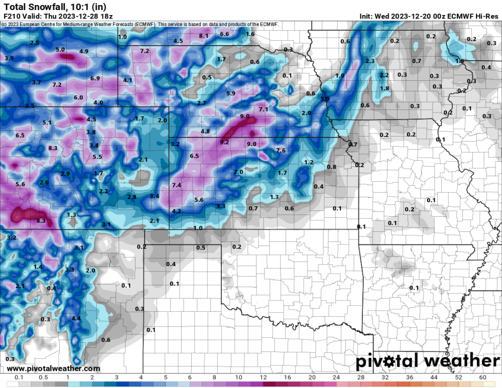
I'd like to see the snow streak extend farther East...still plenty of time to see what this system is made of as it will kick start a massive shift in the wx pattern as we close out DEC and 2023.
Boy the snow line is now knocking on my door. Gonna be an interesting next couple days moving forward! I'm just glad to see the amount of moisture with the system. I'm at the point where I don't care what I get, just give my area precip!
-
4
-
 1
1
-
-
1 hour ago, Beltrami Island said:
I remember hearing the 50s drought was worse than the 30s as well other places online... The difference is the farming practices in the plains were much improved by the 50s (or terrible leading up to the 30s, depending on your point of view) that the dustbowl didn't repeat in the 50s.
Same exact thing a farmer that was around during those times told me! He said the 50's was worse than the 30's but they learned what not to do!
-
1
-
-
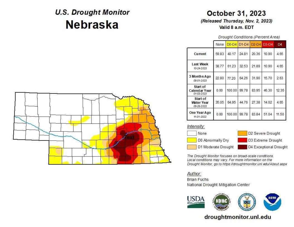
Interesting article about the current state of the drought in my area. I never realized some places are running 25-30" below average for the year! Ever since the floods here of 2019 we have been running below. I have talked to a lot of old timers and obviously the 30's stands out as the worst. Some farmers I have talked about said the 50's was worse. We are currently there right now. Gonna take a lot to get out.

-
2
-
 1
1
-
-
God has gifted us with what appears rain coming out of the sky! Been light pretty much since 3 today. Checked my gauge when I got home from reffing and sitting at .55". Sucks it's not snow but this is the most rain I have seen since October so I'll take it!
-
8
-
-
10 hours ago, CentralNebWeather said:
0.40” of rain so far today, and more has just moved in. Surprising and much appreciated. I guess if we can’t get a snow, at least we are getting moisture.
.10" for me. I watched the radar last night; as the rain lifted up into the worst of the drought stricken area it was like a wall. You could see on radar holes forming. Just can't catch a break in my area.
-
3
-
-
2 hours ago, Tom said:
Well, today is the day Gary Lezak comes out with his Winter Forecast. Anyone have a link to it for a live viewing? Is there a live event?
1 hour ago, Clinton said:I don't think there is a live event just a video and blog on the website. I don't think it's up yet.
Pretty sure we won't be able to see though. I'm thinking you have to be a paid subscriber to see?
-
3
-
-
21 hours ago, CentralNebWeather said:
Absolute comical how the drought continues to show its ugly face. You can't make that up; nice solid strip of nothing right thru my area. Looks like things will only get worse around here if storms continue to do this.
-
1
-
 3
3
-
-
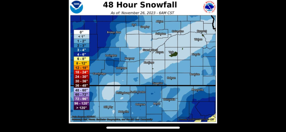
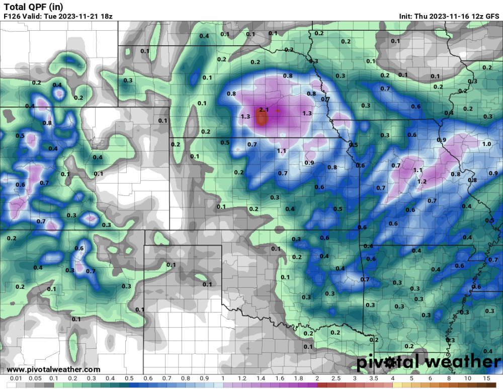
9 hours ago, CentralNebWeather said:
How about this map? So close, yet so far away.
Seen that earlier today, just brutal! You for sure have the best chance out of all of us east best of luck!! I predict you see 3+ you always seem to over perform.
-
3
-
-
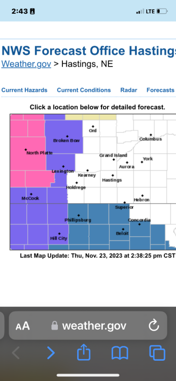
Drought area showing it’s ugly head. The snow line literally stops one county to my west. Sure hope this is the last time I see this uggg. Good luck to the rest of you and happy thanksgiving!
-
5
-
-
Well just another disappointment in the drought stricken areas of eastern Nebraska. Unless wrap around brings more will end up well short of forecast. Drought breads drought.
-
1
-
2
-
 2
2
-
-
50 minutes ago, Clinton said:
The GFS showing a nice little drink of water down here I will take it!
Need this so bad! We are starving for moisture in my area. I haven't seen over an 1" of rain in over 2 months.
-
3
-
1
-
-
1 hour ago, Black Hole said:
Wow very nice job!!! Lots of good information there.
-
1
-
-
Just bad luck for my area in terms of the drought conditions. This is one of the longest stretches with being in the worst category from what I can remember. Obviously you don't bust a drought in the winter; just hoping we can stay at average or just above for the winter months otherwise next spring will be in a bad bad situation around here.
-
3
-
2
-
 1
1
-
-
16 minutes ago, Hoosier said:
I'd have to go back and look at specifics, but in short, that was a very blocky winter.
2 hours ago, sumweatherdude said:Why was 2009-10 such an outlier in terms of temps for a strong Nino? Anything we can point to?
Big thing I remember was the nao and ao was negative pretty much all winter.
-
1
-
-
Didn’t get much precip but getting the first flakes of the year!

-
7
-
-
Well what looked like a great chance of a soaking turns into a dud for me. Sitting at .03” for the past couple of days and not looking for much more. Will see if I luck out with some snow…..
-
4
-
2
-
 1
1
-
-
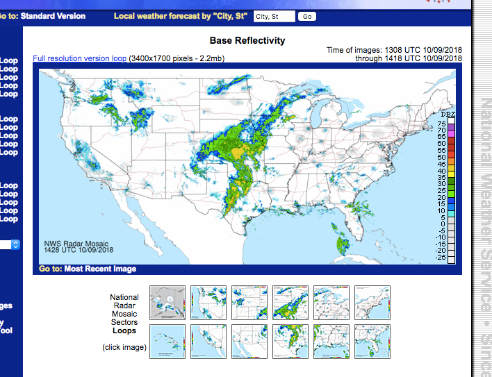
For those of you who are interested in understanding the LRC here is a snap shot. This was from back in 2018-2019, I took a screen shot of the storm system that affected us in Oct of that year. The other image is when the bomb cyclone hit my area that March. Pretty remarkable how the systems not only resemble each other; the storm almost hit on the same exact date 5 months later!
-
5
-
-
14 hours ago, CentralNebWeather said:
Would bring back memories of the Halloween Blizzard of 1991. I would say that is a top 5 in the best blizzards that I’ve lived through in Central Nebraska. Not calling for a blizzard, just remember the record cold of late October into November 1991.
I remember that really well. We had halloween canceled that year I was so mad! We had that really cold stretch at the end of Oct. into Nov. but then after that the rest of the winter was a blow torch. I think it was like 70 on x mas that year.
-
2
-
-
Getting hit by wrap around precip. I may end up with .5" after all is said and done. Disappointed my area missed out on the heavy rain and severe weather but glad to see a strong system in our area. I think this might be a signature storm in the future for a lot of us.
-
2
-
-
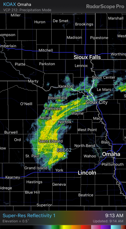
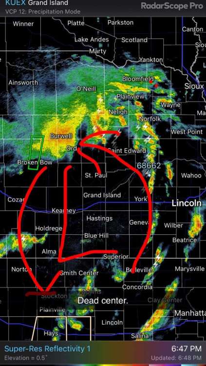
Dead center.
-
2
-
1
-
-
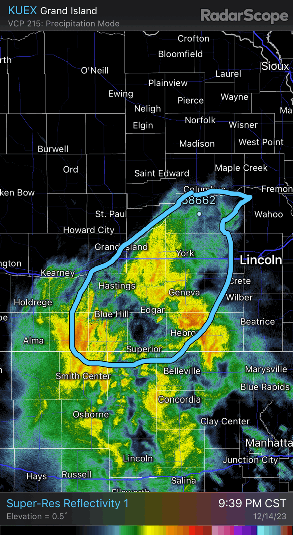
26 minutes ago, CentralNebWeather said:
Tornado Warning, we are all in the shelter here at the High School
Might be in there for a while!


Christmas Blizzard 12/20 - 12/28
in East of the Rockies
Posted
No thank you on the 12z gfs. That retrograde west shuts off precip and snow. I continue to like the look of the early stages of the nam. Come on and hold serve euro.