


gabel23
-
Posts
2289 -
Joined
-
Last visited
-
Days Won
5
Everything posted by gabel23
-
In-accuweather....
-
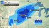
Hastings snowfall forecast. I'm in the 6-8"!! If this plays out, my november snow total would be over a foot!!
-
Correct me if I'm wrong Tom, didn't we have a hurricane in the same spot when the LRC was setting up this fall?! This storm should feed off that hurricane that currently is in progress with this system, interesting times ahead.
-
My bad, I posted this in the wrong storm. I just fixed it.
-
This storm over performed for my area!! I just got back from David City; the roads were pretty much all ice but as long as you drove slow you were ok. I received 4" of snow, my first white thanksgiving in recent memory. That coupled along with a glaze of ice below makes for a sloppy mess around town. Our local station KOLN/KGIN's rpm model was the only model I seen call for 3-5" of snow in a small band. I'm pretty happy to say the least, I'll add some pics tomorrow!
-
-
Currently freezing rain/sleet/ice pellets and coming down pretty good. Things are iced up pretty good, including the roads. I'm gonna be heading to David City to my in-laws so that drive should be interesting. Hoping for a change over to snow before things finish up.
-
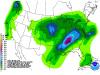
Interesting update by oax, cold air might be quicker than they thought thus the increase in snow totals. .UPDATE... ISSUED AT 1014 PM CST WED NOV 25 2015 NO CHANGES WERE MADE TO THE HEADLINES FOR THURSDAY WERE DONE WITH THIS UPDATE. THE MAIN CHANGE TO THE GOING FORECAST WITH THIS UPDATE WAS TO SPEED UP THE TIMING OF THE COLD AIR JUST A TOUCH...AS WELL AS INCREASE THE SNOW AMOUNTS IN A BAND FROM AROUND KOLU TO KTQE. GOING FORECAST APPEARED TO BE ON TRACK THIS EVENING WITH THE SFC BOUNDARY ALMOST CLEAR OF THE CWA TO THE SOUTH WITH ONLY KFNB AND KICL STILL IN THE WARM SECTOR. COMPARISON OF SFC OBSERVATIONS TO MODELS INDICATE THAT MODELS ARE DOING WELL WITH THE TEMPERATURES DIRECTLY BEHIND THE FRONT BUT ARE A BIT TO COOL DEEPER INTO THE COOL SECTOR OVER NORTHERN NEB/SE SD. DESPITE THESE SMALL ERRORS OF BEING TO WARM IT APPEARS THAT THE COLDER AIR IS GOING TO MAKE IT IN HERE A BIT FASTER THAN EARLIER FORECASTS. THUS HAVE SPED UP THE TIMING OF THE CHANGE-OVERS ACROSS THE CWA ON THURSDAY MORNING. WOULD EXPECT AT LEAST THE WESTERN HALF OF THE OMAHA METRO TO SEE SOME FZRA BY 15Z WITH THE REST OF THE METRO SEEING FZRA BY 18Z. TO THE NORTHWEST THERE IS A VERY NARROW BAND WHERE THE SOUNDINGS SUPPORT ALL SNOW...AND GIVEN THE WEAK STABILITY /EVEN SOME UPRIGHT INSTABILITY NOTED ON SOME NAM SOUNDINGS AROUND 15Z THU/ THERE COULD BE MODERATE TO HEAVY SNOWFALL. HAVE INCREASED SNOWFALL IN THIS ZONE TO 2 TO AS MUCH AS 4 INCHES...AND WOULD NOT BE SURPRISED TO SEE AN ISOLATED 5 INCHES IN THERE AS WELL. GIVEN THE NARROW BAND OF TRANSITION THERE IS STILL SOME UNCERTAINTY AS TO A QUARTER INCH OF FREEZING RAIN...EXCEPT IN PARTS OF SE NEB /I.E. KBIE AREA/ WHERE SEVERAL HOURS OF FZRA ARE EXPECTED IN THE AFTERNOON AND AMOUNTS COULD REACH 0.4 INCH. BUT AS PREVIOUSLY MENTIONED WITH ALL CONSIDERATIONS OF TOMORROW TAKEN INTO ACCOUNT WARNINGS SEEM VERY JUSTIFIED AND MAY NEED TO BE ADJUSTED ANOTHER ROW OF COUNTIES TO THE NORTHWEST OVERNIGHT.
-
Oax calls for 2-4" of sleet/snow for Columbus, which is 20 miles to my north, while Hastings nws calls for .10" of ice and a half of an inch of snow/sleet for me. In my opinion that's a forecast that says I have no idea what is coming.
-
Honestly I can't recall a tougher forecast for our area in a long while. The mini blizzard of April a couple years ago comes to mind with this forecast, biggest difference is what falls?! You can see anything from .25" of ice or 3-4" of snow......
-
I like to see that, 18z nam had most of the precip freezing rain, I would gladly take that.....granted temp profiles will be the biggest player.
-
Very interesting, I'm not gonna lie I was pretty much expecting nothing major but things now look horrid for turkey day. Gonna be a very close call between freezing rain, sleet or snow. I'm hoping we see mostly sleet and snow more than freezing rain. I have to travel back and forth from David city and Shelby. Add the fact I have my big team scrimmage Friday morning and that has me very worried; nothing worse than high school kids trying to get to practice in freezing rain! We all hate sleet but.....give us that rather than freezing rain!!
-
Ha, that's funny. We don't stand a chance at much of anything with the AO/NAO being positive. Systems are just too darn progressive....
-

Midwest & Great Lakes November 20-21st Snowstorm
gabel23 replied to Geos's topic in East of the Rockies
What's crazy is looking at all of the GRID's in Iowa, already they have rain likely next week around thanksgiving. This coming after the fact that a lot of the state north of I-80 received 10+ inches of snow.....flooding next week?! -
Midwest & Great Lakes November 20-21st Snowstorm
gabel23 replied to Geos's topic in East of the Rockies
Congrats to all with the snow, enjoy!! It's hard to say I'm not jealous, hopefully our luck will finally change this year. It has been a very rough couple years for us but things have to change eventually. One thing is certain, the Iowa and Purdue game tomorrow morning at Iowa City will be brutal, I hope Iowa holds serve so the huskers can ruin their run at the CFP next week on Black Friday!! GBR -
11/16 - 11/19 Rocky Mtn - Great Lakes Autumn Storm
gabel23 replied to Tom's topic in East of the Rockies
What a storm, if this was all snow I would have seen 2 feet plus! I ended up with 1.8" of rain and some heavy snow with huge flakes this morning. I wasn't in town all morning as I teach over in rising city but the roads were slushy and ground was covered white. Has been a very wet couple weeks and hopefully next time around this storm produces all snow!! Below is Hastings summary of the storm, including just the second ever recorded tornado in November for the CWA!! http://www.weather.gov/gid/nov16172015 -
For sure, he mentions kc will see a wild swing with weather. If that jet stream is the dominant feature, all of us will be in for a hell of a winter and severe weather season.
-
Here is a teaser put out by Gary Lezak tonight, once piece of the LRC this year. He mentions this will be one pattern we will see repeat this winter. The one caveat to the winter......near to above average temps nation wide.
-
11/16 - 11/19 Rocky Mtn - Great Lakes Autumn Storm
gabel23 replied to Tom's topic in East of the Rockies
Correct me if I'm wrong, the comma head is currently undergoing formation?? Another deformation zone is setting up right over central/western nebraska? This is crazy, but I would think for sure this storm system would have rung itself out by now! Looking at the national radar, its impressive seeing the stream of precip out in front of the low, and another area of precipitation forming over nebraska. -
11/16 - 11/19 Rocky Mtn - Great Lakes Autumn Storm
gabel23 replied to Tom's topic in East of the Rockies
Holy cow that baby is knocking on my door!! Quiet the surprise considering I thought there was no way i was going to have a chance at snow. -
11/16 - 11/19 Rocky Mtn - Great Lakes Autumn Storm
gabel23 replied to Tom's topic in East of the Rockies
That is crazy! North Platte now included in the Blizzard warning, they are looking for 10-14" of snow. I picked up .90" of rain over night, hoping to see more and maybe a little snow to end it. -
11/16 - 11/19 Rocky Mtn - Great Lakes Autumn Storm
gabel23 replied to Tom's topic in East of the Rockies
Has a ways to go before I see any of the white stuff....I just want a heavy dose of rain and for this storm to cycle back and affect me in the heart of winter!! I'll gladly take the rain, I recently tilled up part of my lawn and put a big load of chicken crap on it. Come this spring time hopefully a lot of precipitation has fallen and allows that soil to mellow out. -
Can you repost, the map isn't showing up?! Thanks!
-
I have always loved weather and was good at math. In fact I was originally a meteorologist major but the fact I couldn't get thru the higher levels of math did me in. Interesting book though to say the least, thanks for sharing!!
-
Got to take advantage of the nice weather!! I start basketball practice tomorrow so my time will be limited. I don't mind putting my timers up in cold weather, the lights not so much. I'm hoping we can get a decent snowpack going around or after thanksgiving.....nothing makes the lights look better than a deep snowpack!!


