gabel23
-
Posts
2290 -
Joined
-
Last visited
-
Days Won
5
Everything posted by gabel23
-
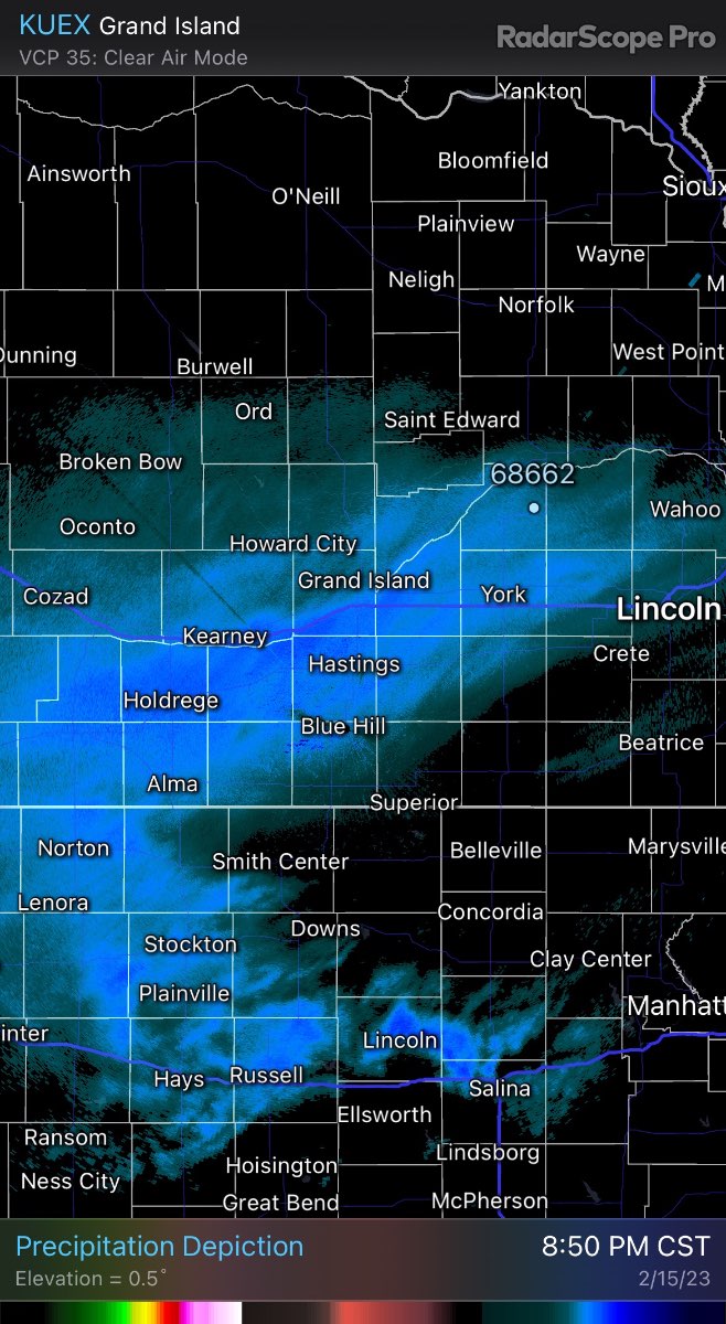
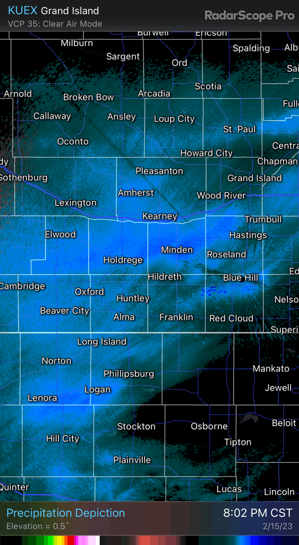
Pretty clear banding showing up right a long the platte river. It’s full so hopefully that can add some moisture to this band……
-
Snow is pulsating right over your area. River effect snow?? Hoping it rides it’s way up north into my area.
-
Pretty strong vort sig.

-
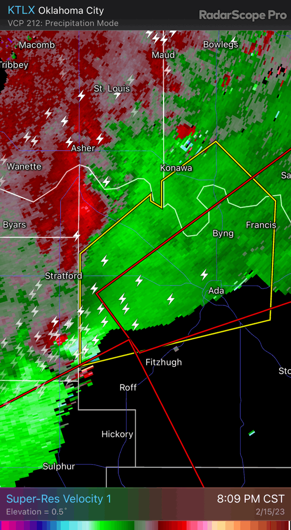
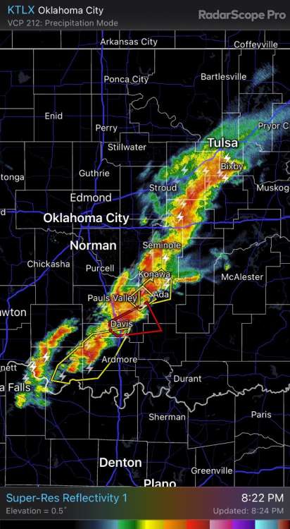
Meanwhile south east of OKC…..
-
The dagger that Jim Flowers keeps referring to is showing up nicely into my area per the 18z run of the euro. Meanwhile radar is showing snow and nothing is falling.
-
Looks like dry air is winning out north of I-80 into my area. This dreaded drought is gonna keep playing a role on systems until we can snap it.
-
For reference, here is what was being shown this morning. Still don't trust anything until we get to the darn event but things have trended up for sure.
-
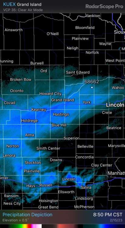
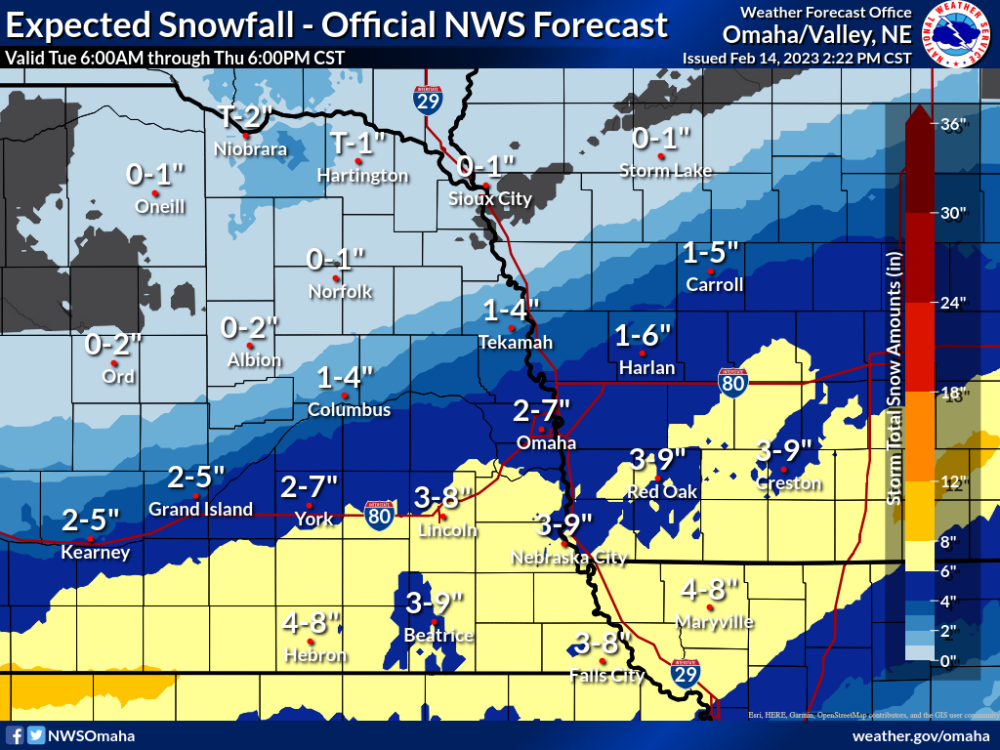
I have now seen the NWS forecast for snow double since this morning. I like to use this winter page when we get close to the event. Usually it's pretty good. OAX is the only one who breaks it down by county. Butler county to my east is forecasting 4-6". I would take that and run.
-
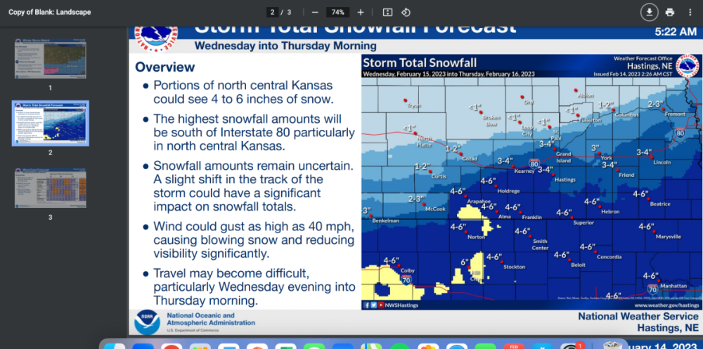
Congrats @CentralNebWeather you reel in another one. You been killing it all year. I'm gonna ride the line all the way to the finish line. If I had to guess I'm too far north to get anything significant. URGENT - WINTER WEATHER MESSAGE National Weather Service Hastings NE 207 PM CST Tue Feb 14 2023 NEZ072>077-082>085-151300- /O.EXA.KGID.WS.A.0002.230215T1800Z-230216T1800Z/ Gosper-Phelps-Kearney-Adams-Clay-Fillmore-Furnas-Harlan-Franklin- Webster- Including the cities of Elwood, Johnson Lake, Holdrege, Minden, Hastings, Sutton, Harvard, Clay Center, Edgar, Fairfield, Geneva, Exeter, Fairmont, Cambridge, Arapahoe, Oxford, Beaver City, Hollinger, Alma, Orleans, Franklin, Campbell, Hildreth, Inavale, Red Cloud, Blue Hill, Rosemont, and Bladen 207 PM CST Tue Feb 14 2023 ...WINTER STORM WATCH IN EFFECT FROM WEDNESDAY AFTERNOON THROUGH THURSDAY MORNING... * WHAT...Heavy snow possible. Total snow accumulations of 4 to 7 inches possible with localized higher amounts. Winds could gust as high as 40 mph. * WHERE...Portions of south central Nebraska. * WHEN...From Wednesday morning through Thursday morning. * IMPACTS...Plan on slippery road conditions. Areas of blowing snow could significantly reduce visibility. * ADDITIONAL DETAILS...Snowfall amounts remain uncertain with this system. A slight shift in the track of the approaching winter storm could have a significant impact on snowfall totals. PRECAUTIONARY/PREPAREDNESS ACTIONS... Monitor the latest forecasts for updates on this situation.
-
Yeah we are going to be riding the edge. Seems like we have these types of set ups all the time.
-
Well the 0-7” is not gonna cover that run for my area! Seriously why is everything we have to go off of have to be such a s-show?! Let the fun begin! Let’s see what crap the gfs throws at us.
-
18z is a complete crush job for most of us Nebraska folks. Would more than enough make up for the misery we have seen. Unfortunately it’s the 18z gfs and we are over 90 hours out.
-
I don't like this set up. Just like @Money said; it's very hard for back to back waves to produce something significant with the second piece of energy. Time will tell I guess.
-

February 2023 Observations and Discussions
gabel23 replied to Iceresistance's topic in East of the Rockies
Meanwhile us in Central/Eastern Nebraska mother nature has thrown us the finger. -
February 2023 Observations and Discussions
gabel23 replied to Iceresistance's topic in East of the Rockies
This is impressive. -
Crazy the difference a year makes! For us, it's been two years but you have to figure sooner or later we will get back to a snowy winter.......
-
1/29 - 2/4 Southern Plains Double Trouble Winter Storms
gabel23 replied to Iceresistance's topic in East of the Rockies
Man just think if the thermo profile was better for you guys! You would be buried in snow! Enjoy, been watching clips and it looks pretty wild down there. -
1/28 - 1/29 Weekend Snowstorm - Plains/MW/GL
gabel23 replied to bud2380's topic in East of the Rockies
Currently 6 degrees and some fat flakes flying! At least it feels a bit like winter. -
1/28 - 1/29 Weekend Snowstorm - Plains/MW/GL
gabel23 replied to bud2380's topic in East of the Rockies
Hard to tell but I’m guessing I picked up 1-2” of straight fluff. It was blowing around nicely yesterday. My snowpack is around 4” and I’m glad most of it was able to survive the warm temps before this storm rolled through! -
Well; I don't want to be selfish and say I'm jealous of what happened in Central Nebraska. Congrats out there; I got 6.5" of snow in pretty much 6 hours. I was worried that dry air/sleet was gong to cut into my chance at snow. Once it started it came down in buckets. I feel bad for those of you who missed out and that sucks about JIm. Forecasting snow is the hardest thing in the world and I can't believe how many mets are taking heat. They don't need that! LASTLY, SHOUT OUT TO THE NAM! It was pretty darn spot on with the storm within 48 hours; it was really the only one showing the dry air/dry slot showing up in Southeast Neb. It pretty much nailed my forecast. The GFS/Euro/Canadian all had me getting 12+.
-
What’s that band doing over you now and how’s the wind?? Snow has stopped here and wondering what that band will bring!
-
It’s been a crazy day here. I seen snowfall rates of one to 2 inches an hour for a solid four hours. Just when I thought the dry air would win out, we now have switched back over to heavy snow. roughly eye balling 5” here and hoping to continue to add to the amount. Hastings seem to think so. They had a great disco today. Glad you did well! Elsewhere, likely looking at another 1-3hr of hvy snow for most areas between Hwy 6 and Hwy 92. By 6-7PM, the best snw accums will have shifted to areas along and N of Hwy 92 where another 3-4" will be possible. Areas along I-80 can expect about another 1-2". When all is said and done, based on current reports and ideas outlined above...think a significant portion of the CWA along and north of a line from HDE to GRI to OLU will have 12-18" of snow, perhaps higher in the ODX area. Even Hastings, which was essentially snow free thru noon, may wind up with 10-12", which would be very impressive. No other way to put it besides saying this is one of the most intense bursts of snow this forecaster has experienced in this area - particularly in terms of snow rates AND duration of high snow rates. IMG_2335.MOV
-
Talked to a buddy of mine who lives in Lincoln he said they have running water down the streets!
-
IMG_2332.MOV Finally transitioned over to snow about 12:45! That was something to see. We slowly went from graupel and ice pellets, with flakes slowly mixing in. Then boom, flakes got huge and it's just puking snow! Big old fat flakes falling.