

snowstorm83
-
Posts
1817 -
Joined
-
Last visited
-
Days Won
1
Everything posted by snowstorm83
-

July 2022 Observations and Discussions
snowstorm83 replied to Clinton's topic in East of the Rockies
Wow, that's amazing what the difference is a couple hours west! None of the storm chances for Lincoln have materialized. Less than 0.50" has fallen since July 7th with nothing in sight. -
July 2022 Observations and Discussions
snowstorm83 replied to Clinton's topic in East of the Rockies
That 0.5-1" turned into scattered light showers today -
July 2022 Observations and Discussions
snowstorm83 replied to Clinton's topic in East of the Rockies
Hit 102 today but the 10 day forecast is the most tolerable we’ve seen since early June, no 90s at all. Could probably use the rain too, basically hasn’t rained in almost 3 weeks -
July 2022 Observations and Discussions
snowstorm83 replied to Clinton's topic in East of the Rockies
Lincoln hit 100 or higher 17 times in 2012 (Omaha 11 times). Average is 4 for Lincoln, 2 for Omaha. So far this year is once for both cities. A lot of days in the mid to upper 90s though and we'll be adding on to that this week -
Discussion on Autumn 2022 and New Winter Outlooks Coming Out
snowstorm83 replied to Niko's topic in East of the Rockies
December 2000 was notable for the consistency of well below average temperatures east of the Rockies, though there was never really an insane arctic plunge. Lincoln had the 3rd coldest December on record, only behind 1983 and 1909. 3rd coldest down in Memphis as well, and most impressively the temperature didn't hit 40 for 18 consecutive days (Dec 17-Jan 3). Very dry, with the most significant snowfall being 2" on New Years Eve. It seems like biggest extremes were centered over Iowa. DSM had the 2nd coldest Dec behind 1983 and picked up 30.3" of snow. Disclaimer: I was 1 years old at the time so this is based off NWS data -
July 2022 Observations and Discussions
snowstorm83 replied to Clinton's topic in East of the Rockies
McCook hit 111 today. It seems like that southwestern area of the state always gets crazy high temps. -
July 2022 Observations and Discussions
snowstorm83 replied to Clinton's topic in East of the Rockies
Nebraska summers are definitely hot and humid, but the south is on a completely different level. 93/74 is no fun here, but that's just a regular summer day in Memphis. And when it's in the upper 90s/triple digits there, dews will usually be above 75. -
Discussion on Autumn 2022 and New Winter Outlooks Coming Out
snowstorm83 replied to Niko's topic in East of the Rockies
Yeah it would be really unfortunate to break the least snowiest winter on record again....lol -
Discussion on Autumn 2022 and New Winter Outlooks Coming Out
snowstorm83 replied to Niko's topic in East of the Rockies
My prediction: LNK will receive more snow than last winter -
July 2022 Observations and Discussions
snowstorm83 replied to Clinton's topic in East of the Rockies
#JustGfsThings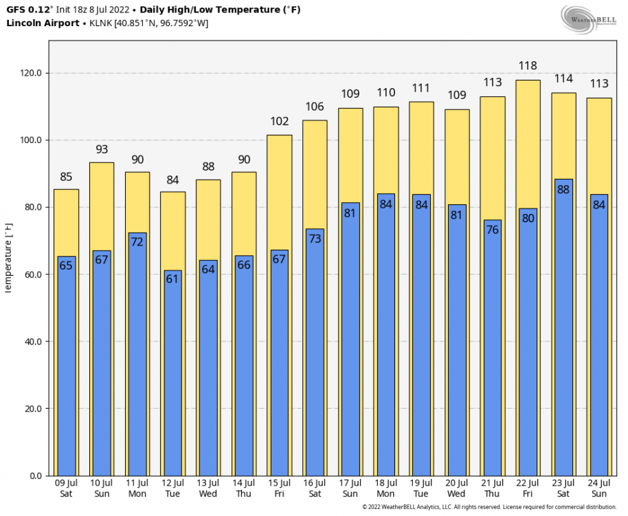
-
July 2022 Observations and Discussions
snowstorm83 replied to Clinton's topic in East of the Rockies
More like a flash flood tonight than last night's no show. 1.74" fell at the airport, 3-4" in Malcolm (NW of Lincoln), while only 0.75" in SE Lincoln -
July 2022 Observations and Discussions
snowstorm83 replied to Clinton's topic in East of the Rockies
Missed again in Lincoln, but the gust front moving through cooled things down nicely. 98 yesterday and 99 today with 105+ heat index. -
July 2022 Observations and Discussions
snowstorm83 replied to Clinton's topic in East of the Rockies
Technically not in drought anymore in this corner state, but hate to see the majority still in D1-D3. And it hasn't been exactly wet around here lately either, just a few brief showers since June 17th. OAX now saying 101 Tuesday, though they've been aggressive at times with heat this year they might be right with this one. Rough start to summer back at my parents in the Memphis area is well, only 0.88" fell in June (10th driest on record). -
Last winter was terrible for our areas, probably a good thing you missed it. Though at least Sioux Falls got a 10" dumping in December (which melted a few days later).
-
LNK "only" hit 95 for this heat wave. Probably traded lower temps for higher humidity, but 103/65 like last week isn't exactly pleasant either. And now the forecast doesn't look as dreadful at least, Friday at 97 looks to be the bad day.
-
Currently 91/74 creating a heat index of 100
-
Hailing in SE Lincoln, pretty rough storm moving through
-
Seward got hit pretty hard last night with hail and wind. Almost got completely missed in SE Lincoln, but still managed to pick up around 0.5". Now this upcoming heat stretch looks even worse than the last Saturday Night Mostly clear, with a low around 77. Juneteenth Sunny and hot, with a high near 103. Breezy. Sunday Night Mostly clear, with a low around 81. Breezy. Monday Sunny and hot, with a high near 103. Breezy. Monday Night A slight chance of showers and thunderstorms. Mostly clear, with a low around 78. Tuesday A slight chance of showers and thunderstorms. Mostly sunny and hot, with a high near 98.
-
Tornado warning for northern Lancaster county
-
0.75" hail reported in Beatrice after getting absolutely wrecked a few days ago
-
I've noticed that there's no longer a +10-15 degree bias on the GFS for summer heat waves. I wonder what the deal with that was last summer.
-
102/67 at the 4pm LNK observation, so daily record is at least tied
-
OAX grids are now up to 105-106 in Lincoln, that seems aggressive but we'll see how far dews drop. Still swampy this morning, woke up to 80/75
-
Already 102 in the grids for next Sunday. I feel like it's not a good sign for OAX to throw out triple digits 7 days out.
-
Completely missed this afternoon in Lincoln, now we move on to the regularly scheduled June record heat again.


