


bud2380
-
Posts
5974 -
Joined
-
Last visited
-
Days Won
11
Posts posted by bud2380
-
-
Got a decent downpour here and some really loud thunder, but the wind never really picked up much at all. It wasn't anywhere near severe level. The warning seemed unnecessary.
-
 1
1
-
-
9 minutes ago, Hawkeye said:
Radar sure doesn't look like a severe event. It's just a wide band of showers with embedded brief downpours.
Agreed, not very impressive. There were some severe thunderstorm warnings, but those have elapsed and not issued further north. Looks like we'll have 2 waves of storms, maybe the second wave will be more intense.
-
ARW mid afternoon.

NSSL

HRRR

-
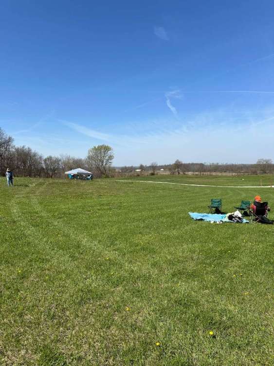
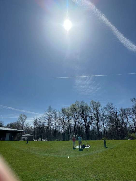
Setup at a farm in Edinburgh, IN. Beautiful weather currently. I believe totality here is supposed to be 3 minutes and 56 seconds. It will be my first total eclipse. Looking forward to it.
-
4
-
 1
1
-
-
I'll be in Edinburgh, IN Monday for this. As of right now the Euro looks great and the GFS looks iffy at best. Hoping King Euro wins again.
-
1
-
-
Snow mixing in here as well on the very SW side of CR.
-
1
-
-
Well the GFS shows 12.6" of snow falling in Iowa City by 1pm. Hard to imagine how a model could be so far off. That would mean 6" per hour starting right now to hit this mark.

-
 1
1
-
-
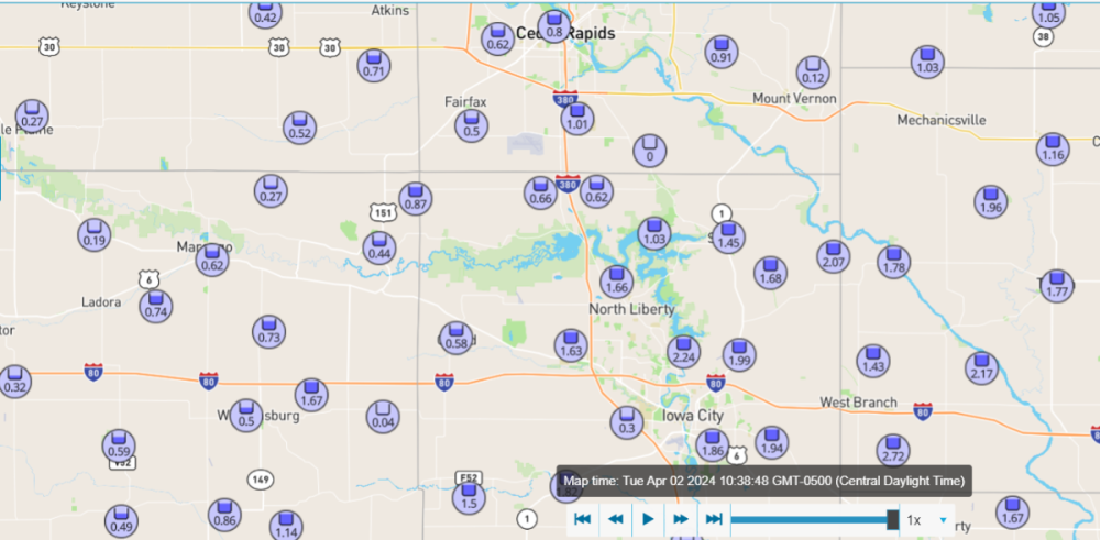
Impressive rain totals so far near Iowa City and surrounding areas. Not quite as much in my backyard.
-
2
-
-
-
1
-
-
HRRR continues to show that rain will change to snow here. And although it will likely be hard to accumulate, it should come down pretty good for a bit.

-
1
-
-
GfS showing stupid amounts of snow.
-
Euro isn't too different.

Ditto Canadian

-
 2
2
-
-
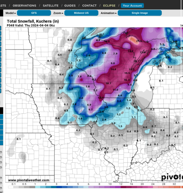
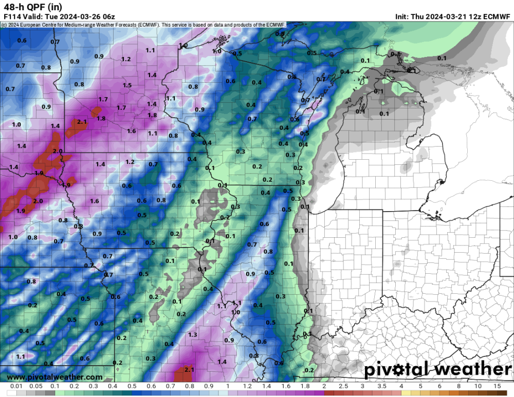
12z model runs showing warning criteria snow for much of central and eastern Wisconsin. They may get hammered tomorrow and Wednesday. The storm even starts to throw snow back into eastern Iowa. The GFS is the most aggressive. Showing 10:1 maps just to illustrate snow potential, but actual accumulations would be considerably less.

-
GFS and Euro are way apart still. Since the Euro is much worse here, I'm assuming it will be more correct than the GFS.


-
2
-
-
Pretty awesome feature by Pivotal to have this on their maps. Hour 270 cloud forecast is probably the least trustworthy forecast I could think of, but I'd still feel better if it showed clear skies right now.

-
1
-
-
We just changed over to a little light snow here in CR. But it's already almost done. We finally got some decent rain at least as well. Reports of about 0.4" near my house. I'll check my gauge when I get home tonight.
-
4
-
-
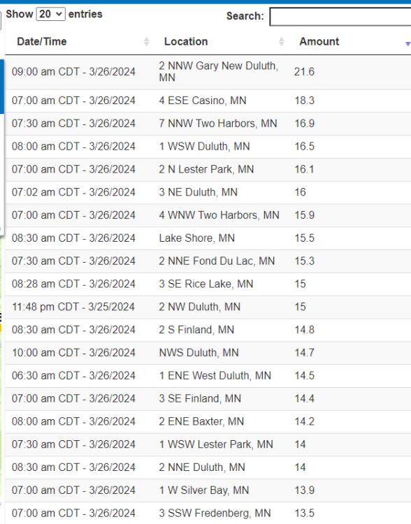
Impressive totals in northern MN.
-
4
-
-
Both Cedar Rapids and Iowa City airports have reported 0.00" of rain so far. A far cry from the 2-3" modeled for days here. Latest HRRR shows about a .25-.35". And that will pretty much be all that we get from this system. A huge disappointment around here. Although with models trending this way in the couple of days leading up to the storm, it was no longer a surprise.

-
1
-
 3
3
-
 1
1
-
-
15 minutes ago, Hawkeye said:
I finished with 5.9" on the west side of Cedar Rapids. My liquid total is a much-needed 0.74". The very max part of the band dropped close to 7" just a hair north of me, but I am super thrilled with what I got.
That's amazing. The NWS didn't buy into the models (namely Euro and HRRR) that were showing the Highway 30 corridor getting hit hard yesterday. They should have.
-
3
-
-
Measured 3.8" at work final total. I won't be home to measure at my house until it's melted and compacted, so this is the only total I'll be able to report.
-
3
-
-
Some impressive totals so far. I just measured again at work and got 3.3". I'm guessing North Liberty will end up with 4-5" as it has been just ripping down there for awhile now.
-
1
-
1
-
-
1 hour ago, Hawkeye said:
The snow is ripping pretty good here. The ground is completely covered. I'm guessing we might get a couple inches.
Just measured 2.5" at work when I finally got here. The snow in North Liberty and Tiffin was coming down extremely hard. Flakes were half dollar sized. The radar was red like a thunderstorm, although I did not hear any thunder or see any lightning here. I'm guessing we see 4+" reports for sure.
-
2
-
-
57 minutes ago, Hawkeye said:
Ugh.... the big storm has totally dried up for eastern Iowa. The latest Euro has dropped from 2-3" to almost nothing. Unreal.
That's unreal.
On the plus side the Euro shows 6" of snow tonight for Cedar Rapids! LOL.

-
2
-
1
-
-
The Euro's QPF totals are much better in Iowa than the GFS.

-
1
-


April 2024 Observations and Discussion
in East of the Rockies
Posted
I see the airport is reporting a 48mph gust. I don't get it. I can literally see the airport out my office window at work and it didn't get nearly that windy here. I've golfed in stronger winds than what just moved through.