


bud2380
-
Posts
5974 -
Joined
-
Last visited
-
Days Won
11
Everything posted by bud2380
-

January 2024 Observations and Discussion
bud2380 replied to Minny_Weather's topic in East of the Rockies
Improvement on the GFS but still pretty sad looking. -
January 2024 Observations and Discussion
bud2380 replied to Minny_Weather's topic in East of the Rockies
ICON -
January 2024 Observations and Discussion
bud2380 replied to Minny_Weather's topic in East of the Rockies
RDPS continues to be very strong. -
January 2024 Observations and Discussion
bud2380 replied to Minny_Weather's topic in East of the Rockies
Davenport and LaCrosse didnt mention snow at all for Thursday. Des Moines did and said could be as high as 1-3" if more moisture works in. -
January 2024 Observations and Discussion
bud2380 replied to Minny_Weather's topic in East of the Rockies
Lets hope the Canadian is onto something here. -
January 2024 Observations and Discussion
bud2380 replied to Minny_Weather's topic in East of the Rockies
SREF is further north that the Euro. -
January 2024 Observations and Discussion
bud2380 replied to Minny_Weather's topic in East of the Rockies
Euro dipped south for the system later this week. Similar to the UK, but not quite that bad. -
January 2024 Observations and Discussion
bud2380 replied to Minny_Weather's topic in East of the Rockies
UK model spits this out into two pieces and goes further south before weakening substantially as it heads east. -
January 2024 Observations and Discussion
bud2380 replied to Minny_Weather's topic in East of the Rockies
The RDPS really highlights the potential with this one. This is as far as the model run goes, but you can expand this further east. I don't think this is a true Alberta clipper, but it does appear to be coming from a NW flow. These are always fun when they have a little moisture to work with. With exceptionally cold air already in place, snow ratios should be high and could lead to some very surprise totals. Models always dry these out as they head east, and in my own observation, sometimes dry them out too much, so I'm curious to see what models show over the next 24 hours as we get closer to this event. -
January 2024 Observations and Discussion
bud2380 replied to Minny_Weather's topic in East of the Rockies
NAM is in position too. So the only model really showing nothing is the GFS. -
January 2024 Observations and Discussion
bud2380 replied to Minny_Weather's topic in East of the Rockies
Canadian looks solid too. -
January 2024 Observations and Discussion
bud2380 replied to Minny_Weather's topic in East of the Rockies
12z ICON for the same system Thu/Fri. The GFS dries this thing up completely and really doesn't have a system to speak of. -
January 2024 Observations and Discussion
bud2380 replied to Minny_Weather's topic in East of the Rockies
Euro has been consistent with a weak system Thursday into Friday. -
-
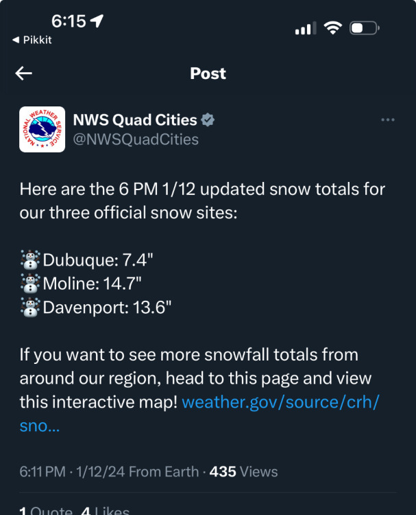
Right on cue.

-
I’m gonna call this 4.5-5”. Again hard to measure. Certainly we didn’t get a lot. It just never snowed heavy here. Still a fun snow day watching it snow. I took the day off work and just enjoyed it. Accumulating snow is essentially done here. Radar is breaking up.
-
Most spotters don't measure properly, so I'll bet we see 5-6" reports out of CR for sure from them if not higher. The Hiawatha spotter always seems to be one of the highest around, wouldn't be surprised if they report 7-8". I'll go out and measure again, but I never saw it snow what I would even call moderate for more than 30 minutes to an hour. It's mostly been just a steady light snow for the last 12-14 hours. I'm guessing we're 4-5" but probably closer to 4". Admittedly I didn't do a good job preparing good measuring spots for this storm. I didn't have any really cleared out areas, so measuring has been very difficult.
-
Difficult measure today. I took several measurements and best guess is 3.5-4”. Probably closer to 3.5. Snow continued to fall lightly. 5-6” is probably where we will finish. Disappointing given what models were showing. But actually a decent storm by Iowa standards.
-
Southeast Iowa got hit hard again. Needed a two county shift north. Snow is coming down harder now and wind is picking up. Measurements will be a nightmare later.
-
I honestly can't get a great measurement here. There was so much snow already on the ground and I didn't clear off the nearly 2" we got Wednesday. My best guess is between 2.5 and 3.5". There is a report of 3" just south of me and that was from at least an hour ago, so seems reasonable. We continue to just get light snow. Perhaps a moderate band is starting to form, but this thing is going to have to pickup dramatically to get to much more than 6".
-
Radar just won’t fill in by my place. Keeps looking better to both the west and east. Like some models had predicted. Snow has picked up a little but it’s still just snowing lightly.
-
Looks like 1.5” here now that I went and measured. Very disappointing so far. 6” seems like the high end unless rates are tremendous later. Radar continues to look poor here.
-
Eye balling looks like 1” here. North Liberty has a report of 4.5” and I don’t believe that for one second.
-
Radar is not very impressive right now
-
Now it’s officially on.


