


bud2380
-
Posts
5974 -
Joined
-
Last visited
-
Days Won
11
Everything posted by bud2380
-
15z RAP just buries many locations.
-
I could see that happening, but I'm not really buying that further north solution just yet. The Euro is the furthest north of the global models. The NAM is way north. The GFS is south, but even if it corrects back north just 50 miles, that is actually better news for you and I, so hopefully the GFS is on to something.
-
The GFS has more than twice the QPF in Eastern Iowa compared to the Euro. Models really are not in sync with this storm, so surprises one way or the other could still be in store.
-
If the NAM and GFS meet in the middle on their track, but keep the same intensity, it would put me square in the jackpot zone.
-
Close up of the GFS for areas further east.
-
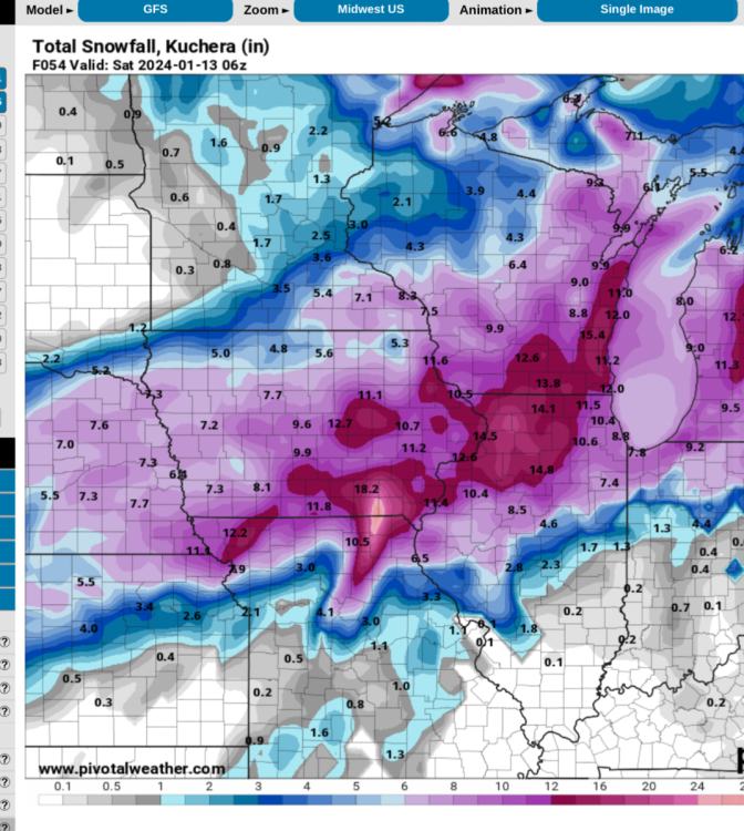
GFS showing 14" in my backyard. LOL. That would be amazing, but I doubt it. Models are still showing a huge range.
-
D**n GFS. @OttumwaSnomow might be busy again tomorrow.
-
I'm glad they said that because the difference between the NAM, HRRR, etc. vs. the GFS and Euro is very significant, at least in my area. So now we know to basically throw out those short term models until they start to come more in line with the globals.
-
-

January 2024 Observations and Discussion
bud2380 replied to Minny_Weather's topic in East of the Rockies
I just drove right through all of that. Couldn’t see the road at all. Had no idea where the lanes were. Just had to basically guess. Got home and measured 1.8” most of which must have fallen in an hour to hour and a half at most. -
NAM isn’t shifting south yet.
-
Is that the "blammo" guy that used to be on KWWL?
-
GFS still looks great for my area.
-
DVN just issued Winter Storm Watches. 4-8” winds gusting to 45mph.
-
My point forecast calls for 5-9". I'm guessing the NWS is siding with the globals for right now. Thursday Night Snow, mainly after midnight. The snow could be heavy at times. Low around 20. Northeast wind 5 to 15 mph, with gusts as high as 25 mph. Chance of precipitation is 90%. New snow accumulation of 3 to 5 inches possible. Friday Snow. High near 28. Blustery. Chance of precipitation is 90%. New snow accumulation of 2 to 4 inches possible
-
ARX (LaCrosse) also issued Winter Storm Watches all the way up to Red Wing, MN.
-
18z HRRR looks similar to the NAM. All the short term models are further north than the global models. Someone has to cave and quick. Storm is almost here. I expect watches will be issued today for at least some areas.
-
12z EPS
-
January 2024 Observations and Discussion
bud2380 replied to Minny_Weather's topic in East of the Rockies
18z RAP slightly further south with the line, but pretty similar. I'm interested to see what the NWS does. It's such a narrow band. -
January 2024 Observations and Discussion
bud2380 replied to Minny_Weather's topic in East of the Rockies
18z HRRR - CR to DBQ could get a Winter Weather Advisory issued if the NWS believes this model. -
January 2024 Observations and Discussion
bud2380 replied to Minny_Weather's topic in East of the Rockies
17z HRRR -
It's basically the NAM ensemble. I guess I would say it does ok. Usually shows higher snow totals than most models. I wouldn't discount it but I wouldn't rely on it any heavier than the GEFS or EPS for sure.
-
That is about the only corridor that was an uptick, and a slight one at that. Western Iowa and Eastern Iowa were down significantly.
-
00z vs 12z This is the 00z 12z through the same time. Seems totals are down probably 25% for many areas.
-
Euro weaker this run in Iowa. QPF overall is lower in the state. Snow totals lower for most areas through 63 hours vs. 00z.


