


Clinton
-
Posts
6460 -
Joined
-
Last visited
-
Days Won
28
Posts posted by Clinton
-
-
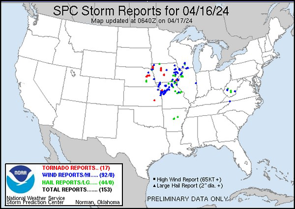
A good amount of severe weather and rainfall from this system.
-
 7
7
-
 1
1
-
-
As expected not a drop of rain fell here yesterday however things are looking good for some beneficial rainfall tonight and tomorrow. The Euro and 3km NAM showing 1in plus for mby and the GFS just a little bit less. I could really use the rainfall, the strong winds yesterday picked up a bunch of dust and blew down trees including a apple tree in my yard.

-
3
-
-
Not expecting much rain here overnight or tomorrow. It's looking like Thursday may be my best shot. I'm so tired of drought!
-
4
-
-
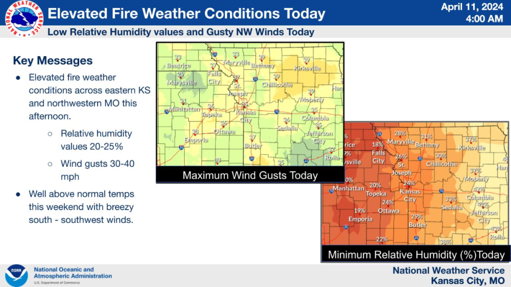
Warm and windy conditions have drought conditions worsening quickly over western MO and other parts of the Midwest. Hopefully some rain is coming this week with a rather robust closed low that should crank out some big storms.
http://www.cpc.ncep.noaa.gov/soilmst/img/curr.w.anom.daily.gif
-
1
-
1
-
-
Cool, windy and dry as a bone here today. Some summer like temps and humidity will have me turning the AC on this weekend.
-
1
-
-
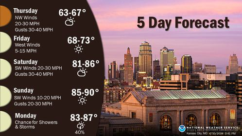
The heat starts to build into the central plains this weekend which will lead to big storms early next week.
-
 1
1
-
-
Severe weather and big time rains across the south the next few days. For mby only the Euro is showing significant rainfall with totals near an inch. All other models have the rainfall to my SE, though the GFS has crept very close.


-
2
-
-
Big jump NW on the 12z Euro for the storm this week. This would give me over an inch of rain on Wednesday. Hopefully other models follow suit.
-
Nice and somewhat boring weather ahead this week around here with all the thunderstorm action in the south. However great viewing for the eclipse this afternoon, I get about 93% coverage.
-
2
-
-
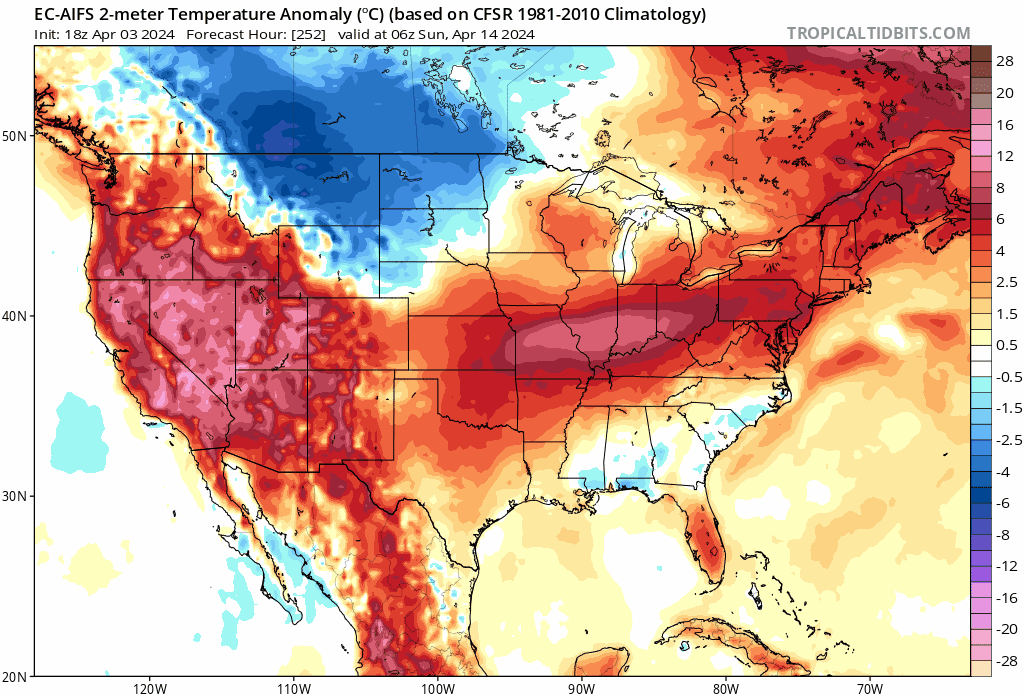
A graduale warm up over the next week for most of the country. The next chance for widespread significant weather should be around the 19th as this part of the pattern produced in early March.
-
2
-
 1
1
-
1
-
-
I received .22 inches of rain with a line of showers overnight. Nice weather today with temps around 70.
-
1
-
 1
1
-
-
Beautiful weather today but windy. Maybe pull in a thunderstorm tonight.
-
2
-
 1
1
-
-
The Euro AI for April 14th 18th Some of you may not be done with snow yet.

-
 1
1
-
 1
1
-
-
Light freeze expected here tonight with lows around 30. Going forward into next week, the blocked up pattern has the operational models struggling. The EPS and GEFS ensemble means are more generous with precipitation and further north than the operational models are currently are.


-
 1
1
-
-
This beast is still spinning


-
2
-
-
Models are in good agreement on a system this weekend that may produce some severe weather.

Not much agreement with the storm system next week but on the backside some more chilly air looks to get pulled in.

-
4
-
1
-
 1
1
-
-
April is going to start off a little cool here with near freezing temperatures the next 2 nights.
-
3
-
-
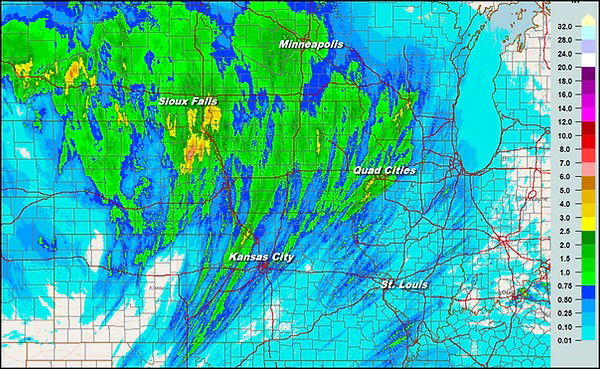
.60 of rain fell here yesterday and overnight, far less than I had hoped but better than nothing. Some aditional rain moving in this morning.
-
1
-
-
The tornado watch for my area has been canceled. Moderate rain has stabilized the air and temps are in the upper 60s. I'm hoping for at least an inch of rain out of this system.
-
1
-
1
-
-
Tornado watch in effect until 11. Hi res models indicating 1 to 3 inches if rain also.
-
1
-
1
-
-
The warm front across my area may be a focal point tonight.
FollowUPDATE: I see three different corridors of TORNADO POTENTIAL: 1. central/northern OK through southeastern KS into southwestern MO along southern surface low track. 2. Red River/southern OK at the nose of expanding low-level jet 3. warm frontal zone along I-70 in Missouri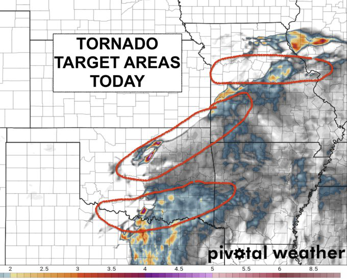
-
2
-
-
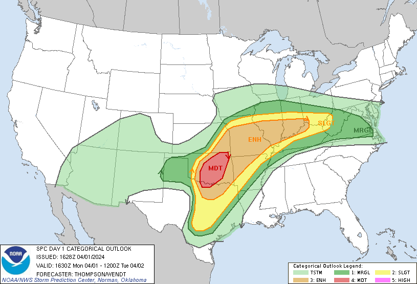
4 minutes ago, Timmy Supercell said:
A Moderate Risk was just placed in central/eastern Oklahoma!
Is this mid-day light rain/cloud gonna clear in these areas? Both here and there looks like we're socked in, and this has been occurring since I moved here. Stuff is thinning but I haven't seen the sun shining all day.
Enhanced risk also moved to include KC.
-
1
-
-
The SPC has shifted the enhanced risk NW back over my area today. 3km NAM and HRRR both showing supercells in my area around 5 pm. I wouldn't be surprised if there's not an upgrade to a moderate risk from mby back into central Oklahoma later today.
The GFS did a pretty good job showing this system phasing with the northern stream as it lifts toward the Lakes this could turn into a nice spring snowstorm for Ill, Wisc, and Mich.
   Day 1 Convective Outlook
   NWS Storm Prediction Center Norman OK
   0106 AM CDT Mon Apr 01 2024

   Valid 011200Z - 021200Z

   ...THERE IS AN ENHANCED RISK OF SEVERE THUNDERSTORMS FROM THE
   SOUTHERN PLAINS TO THE OZARKS AND INTO FAR WESTERN INDIANA....

   ...SUMMARY...
   Severe weather is expected to occur over a broad region from the
   southern Plains, the Ozarks, portions of the Ohio Valley, and into a
   small part of the Mid-Atlantic. Large to very large hail, damaging
   winds, and tornadoes (some strong) are possible. The severe threat
   will peak this afternoon/evening in the southern Plains with the
   greatest threat for the Ohio Valley vicinity being the
   evening/overnight period.

   ...Synopsis...
   A large, positively tilted upper-level trough will shift east from
   the Southwest to the central Plains today. A mid-level shortwave
   trough, currently rounding the base of the large scale trough, will
   advance quickly northeast through the day today within a strong
   mid-level jet. This strong flow will overspread a broad, very moist
   warm sector and lead to severe weather across a large portion of the
   Southern Plains into the Midwest.

   A surface low is present across eastern Colorado this morning with a
   stationary front extending eastward across Kansas and Missouri and
   into the Ohio Valley. This surface low will drift slowly east
   through the day and the front is expected to lift north across
   Missouri as a warm front during the afternoon.

   ...North Texas, central and eastern Oklahoma, southeast Kansas, and
   the Ozarks...
   Mid 60s dewpoints are expected across much of the warm sector east
   of the dryline by mid-day today with temperatures warming into the
   70s to low 80s. Moderate to strong instability is expected to
   develop by the time ascent associated with the approaching trough
   overspreads the dryline. Once this occurs, expect rapid storm
   development along the dryline from southern Kansas to north Texas.
   Very strong shear, and mostly straight hodographs will support
   splitting supercells initially capable of large to potentially giant
   hail across a broad region from southwest Missouri to north Texas.
   Storm evolution off the dryline is still somewhat uncertain. Some
   guidance depicts more discrete development off the dryline and the
   potential for multiple rounds of supercells, while other CAM
   guidance waits until closer to 00Z to convect and leads to upscale
   growth and significant storm interaction within the first few hours.
   This evolution will have a significant impact on the longevity of
   the giant hail threat, but even with a messy storm mode, very large
   hail will remain a threat.

   Low-level shear is expected to be very weak for much of the day,
   which will limit the tornado threat. However, by the evening, the
   low-level jet is expected to strengthen with the ejecting wave and
   low-level shear will improve. The most favorable hodographs are
   expected across northeast Oklahoma into southeast Kansas and
   southwest/central Missouri in a region where mature supercells will
   likely be ongoing. Therefore, a more favorable period for tornadoes
   and potentially strong tornadoes may exist from 23-03Z as the
   low-level shear improves.

   ...Eastern Missouri into southern Illinois...
   At least isolated supercells are expected to develop along the warm
   front from northern Missouri into central Illinois this afternoon
   and evening. Strong instability and very strong shear will support
   large to very large hail. In addition, storm motion is expected to
   be parallel to the surface front. Therefore, any supercells which
   can latch onto the warm front will have a higher tornado threat.
   However, more isolated storm coverage and uncertainty regarding
   storm evolution preclude higher tornado probabilities in this
   region.

   Later in the evening and into the overnight hours, storms from the
   west will move into the region with a threat for large hail, a few
   tornadoes, and severe wind gusts.

   ...Ohio River Vicinity...
   Supercells from Illinois may continue east along the warm front into
   the evening across southern Indiana and potentially southern Ohio.
   Additional storms may also develop along this frontal zone with a
   primary threat of large hail. Weaker instability/shear should limit
   the overall threat from these storms compared to farther west.
   However, moderate instability and strong shear will support a threat
   for large hail, damaging wind gusts, and perhaps a tornado.

   Overnight, a cluster of storms is expected to approach from the
   west. The overnight environment will continue to support a severe
   threat with 1500 J/kg MLCAPE and effective shear in excess of 50
   knots. There is still considerable uncertainty how this cluster will
   evolve. A cluster of supercells would pose a threat for all severe
   weather hazards, while a more organized MCS may support a greater
   severe wind and QLCS tornado threat.

   ...Central Texas...
   Strong instability is expected to develop ahead of a dryline across
   central Texas this afternoon. Confluence along the dryline and weak
   height falls should provide ample support for isolated to scattered
   storm development. Any storms which develop will be capable of very
   large to giant hail, given very strong instability and shear an
   expected supercellular storm mode.
-
2
-
-
5 hours ago, OttumwaSnomow said:
Great call @Tom! Nothing like a wobbling warm front here!!! I just got raked best gully washer since June or longer! 1.32" and still not over! 2 rounds of pea size hail! FINALLY SOME RUN OFF FOR PONDS!
That's what I'm hoping for here this evening. Most ponds are only half full or less and the streams are dry or stagnate.


April 2024 Observations and Discussion
in East of the Rockies
Posted
Another disappointment with rain here only .22 inches. The rain just seems to find away to miss me.