


Sciascia
-
Posts
424 -
Joined
-
Last visited
-
Days Won
1
Everything posted by Sciascia
-

January 11-13 Major Winter Storm/Blizzard
Sciascia replied to Hoosier's topic in East of the Rockies
With the snow from Tuesday & Wednesday night still on the ground/deck (plus the wind), can’t really tell how much I’ve got here in Poplar Grove. Disappointingly in the dry slot, currently. -
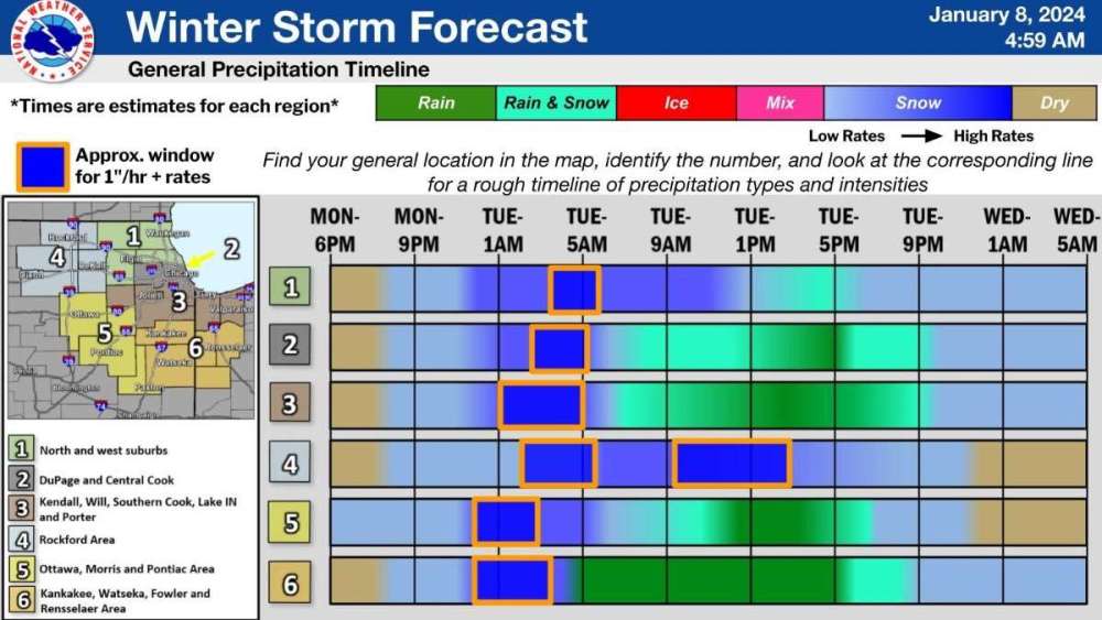
LOT P&C for Poplar Grove is 7-15 potential inches. Gonna be fun to see what unfolds.
-
One of LOT’s several morning graphics. 4th quadrant represent! As a guy that works 2pm - 10pm, having the heaviest portion occur when I’m supposed to drive to work and the blowing snow portion when I’m supposed to drive back home makes me consider burning a vacation day.
-
And heavy snow continuing at the end of the run.


-
This storm is close enough to have the low pop up on the HRRR. Here it is at 48hrs vs. the new NAM:


-
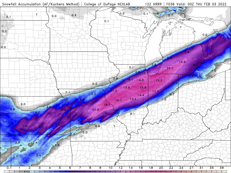
Kuchera map of the last 13 GFS runs, ending 6am Wednesday morning.

-
January 2024 Observations and Discussion
Sciascia replied to Minny_Weather's topic in East of the Rockies
Not sure what’s more unbelievable: The 0z GFS painting 30+ inches at ORD in the next 192hrs, or the 0z and the 6z GFS painting 30 inches there in back to back runs. -
Word has it (from Fox Chicago’s Mike Caplan) that a special mission was done to collect sampling from this system even though it’s not yet on shore. Data was supposed to start appearing in the 00z suite.
-
2/1 - 2/3 MW/Lower Lakes Major Winter Storm (GHD-3)
Sciascia replied to Tom's topic in East of the Rockies
HRRR has been slowly tapping NW with the snow swath in recent runs. 12z had 0.9 inches at ORD at 4am Wednesday. The newest 17z has 3 inches at the same time. -
2/1 - 2/3 MW/Lower Lakes Major Winter Storm (GHD-3)
Sciascia replied to Tom's topic in East of the Rockies
NAM @ 30hrs
-
2/1 - 2/3 MW/Lower Lakes Major Winter Storm (GHD-3)
Sciascia replied to Tom's topic in East of the Rockies
NAM coming in south of 6z with snow area, but fairly the same as 0z. -
2/1 - 2/3 MW/Lower Lakes Major Winter Storm (GHD-3)
Sciascia replied to Tom's topic in East of the Rockies
12z HRRR coming in with a more realistic (albeit less fun) scenario:
-
2/1 - 2/3 MW/Lower Lakes Major Winter Storm (GHD-3)
Sciascia replied to Tom's topic in East of the Rockies
GFS has stopped the north baby stepping, which is slightly disappointing for someone in Boone County hoping to cash in on a double digit number. However, I am glad for those currently forecast for almost 2 feet. -
2/1 - 2/3 MW/Lower Lakes Major Winter Storm (GHD-3)
Sciascia replied to Tom's topic in East of the Rockies
Here’s a GIF of the GEFS ensembles from 6pm Tuesday to 12am Friday. Always kinda neat to see all the different scenarios.
-
2/1 - 2/3 MW/Lower Lakes Major Winter Storm (GHD-3)
Sciascia replied to Tom's topic in East of the Rockies
Just imagine if Ensemble 10 were even close to verifying. Over 2 and a half feet of snow would shut down Chicago. -
2/1 - 2/3 MW/Lower Lakes Major Winter Storm (GHD-3)
Sciascia replied to Tom's topic in East of the Rockies
Any ensemble showing Orange near Chicago is definitely a rare occurrence. -
2/1 - 2/3 MW/Lower Lakes Major Winter Storm (GHD-3)
Sciascia replied to Tom's topic in East of the Rockies
Clifford the (potential) Big Dog! -
-
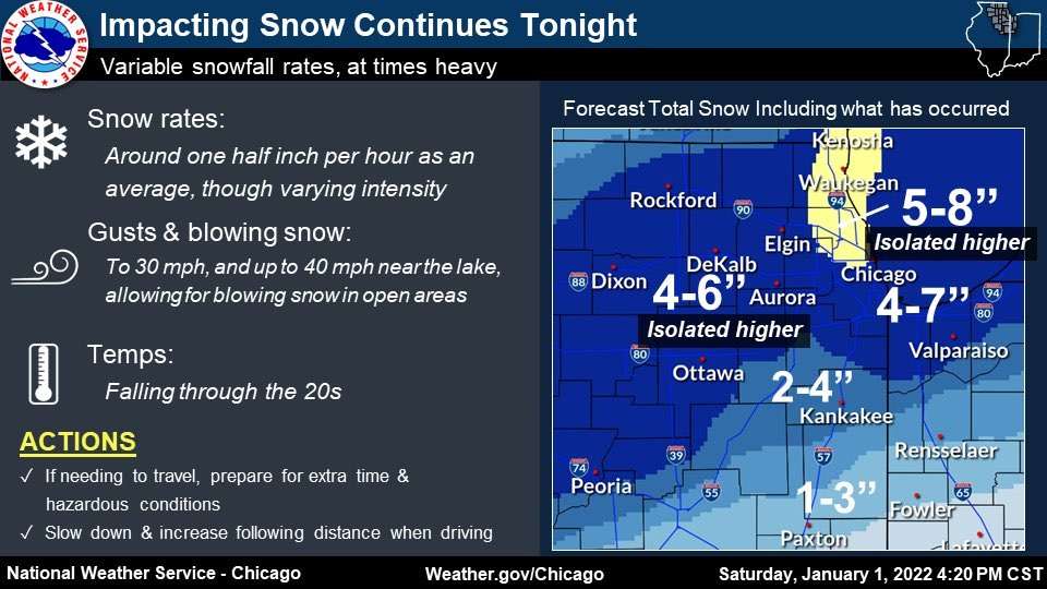
Yeah, pretty peaceful. But not easy to find an internet provider that’s not satellite. I miss my Xfinity internet, lol. LOT with an update: SOME QUESTIONS REGARDING ANY IMPACTS OF UPSTREAM CONVECTION ON POLEWARD MOISTURE TRANSPORT THIS AFTERNOON AND EVENING WITH SEVERAL GOOD-SIZED HOLES NOTED IN THE PRECIPITATION SHIELD ACROSS NORTHERN MISSOURI. THAT SAID, UPRIGHT CONVECTIVE INSTABILITY IS PRESENT ON REGION SOUNDINGS (AND WE CAN SEE THE CONVECTIVE NATURE MANIFESTED IN THE RADAR RETURNS), AND HAVE ALSO SEEN SOME DEGREE OF THIS FILLING IN OVER THE LAST HOUR OF SO WITH THE ARRIVAL OF BETTER JET DYNAMICS. HRRR/RAP COMBO HAVE CERTAINLY TRENDED DOWNWARDS A BIT IN THE QPF OUTPUT AWAY FROM THE LAKE, AND ENVISION THERE WILL BE SOME "HOLES" IN THE SNOWFALL TOTALS IN BETWEEN THE DOMINANT F-GEN FORCING AND AND ANY LAKE ENHANCEMENT. NO MEANINGFUL CHANGES TO THE SNOW TOTALS AT THIS TIME THOUGH, WITH OUR 4-7" INLAND STILL LOOKING OKAY WITH HIGHER AMOUNTS NEAR THE LAKE. WE'LL SEE IF ANY DOWNWARD ADJUSTMENTS NEED TO BE MADE TO OUR NORTHERN TIER OF COUNTIES AWAY FROM THE LAKE WITH THE FULL PM UPDATE.
-
I used to be. Completely moved out to Poplar Grove (25 minutes NE of Rockford) in September. Wife & I bought a house here in 2019, but my job was still near Chicago until Sept.
-
At the very least, it should mean you won’t have dry air issues to deal with
-
LOT has issued warnings for lakeside counties, as well as northern counties like McHenry, Boone (whoo!), and Winnebago.
-
This thing coming apart at the seams (in terms of a big snow) is unfortunate to see.
-
They lowered expected totals…
-
LOT has issued watches for Chicago & other N IL counties. Event: Winter Storm Watch Alert: ...WINTER STORM WATCH IN EFFECT FROM SATURDAY MORNING THROUGH LATE SATURDAY NIGHT... * WHAT...Steady, blowing snow and dangerous travel possible. Total snow accumulations greater than 6 inches and northeasterly wind gusts in excess of 40 mph are possible. * WHERE...Lake IL, DuPage, Northern Cook, Central Cook and Southern Cook Counties. * WHEN...From Saturday morning through late Saturday night. * IMPACTS...Travel could be very difficult. Widespread blowing snow could significantly reduce visibility, especially along the Lake Michigan shoreline. * ADDITIONAL DETAILS...The steadiest snow rates appear most likely between noon Saturday and midnight Sunday.


