


Stacsh
-
Posts
1388 -
Joined
-
Last visited
Everything posted by Stacsh
-
You guys are hilarious. Glad you did “your research to already confirm your political bias”. You found it! Well done. I’ll trust the real scientists
-
Wow lightning and thunder. Still 54 degrees. Very rare thundershower moving through
-
Radar starting to light up. Fluffy light snow beginning. Should pile up but compact as well.
-
Extended WSW until tomorrow. This is quite the point forecast
-
It’s always hit or miss. But I usually do well with a stronger wind out of the west. Any slight sw wind will really get the job done. Either way. Cold and at least light to moderate off and on lake effect snow through maybe next weekend. it’s winter finally.
-
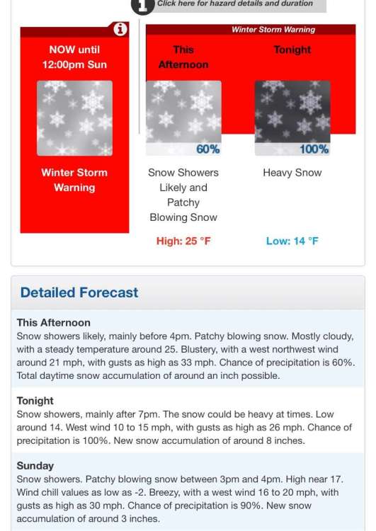
FOR TONIGHT THE LOW LEVEL FLOW GOES WESTERLY AND A SHORTWAVE COMES THROUGH WHICH BRINGS A SIGNIFICANT BUMP IN MOISTURE DEPTH AND INVERSION HEIGHTS PER BUFKIT PROFILES. HIRES DATA HAS A STRONG SIGNAL FOR A STRONG CONVERGENCE BAND SETTING UP NEAR THE I-96 CORRIDOR. THIS OCCURS AS THE VERY COLD AIR IS INFILTRATING OUR SE CWFA FROM THE SOUTHWEST, SETTING UP STRONG LOW LEVEL FGEN FORCING NEAR THE INTERFACE OF THE MUCH WARMER LAKE MODIFIED AIR. BANDS NEAR I-96 SHOULD INTENSIFY BY 10 PM AND WILL BE FAIRLY NARROW SO AMOUNTS TONIGHT INTO EARLY SUNDAY WILL BE QUITE VARIABLE. WHERE BANDS PERSIST IT WOULD NOT BE SURPRISING TO SEE LOCALIZED AMOUNTS UPWARD OF ONE FOOT BY NOON SUNDAY, ESPECIALLY WITHIN A TRIANGULAR POLYGON BOUNDED BY ROUGHLY MKG-BIV-IONIA, INCLUDING GRR. THE WIND REGIME LATER TONIGHT VERY MUCH FAVORS THE GRR AREA/KENT COUNTY FOR SOME HIGHER END L.E.S. AMOUNTS.
-
Not a bad storm. Ended up with around 7”. Up to a foot possible tonight. More likely 4-8”. I’m in a perfect spot for lake effect snow tonight with the w to wsw winds.
-
Major bust here in GR. 5 inches maybe
-
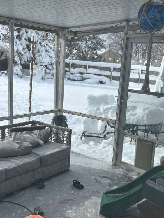
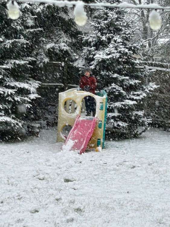
Very pretty and nice snowstorm happening. Snowfall rates aren’t that impressive but moderate snow falling. Wind is picking up. 2 inches down since 2 pm eastern. It’s certainly a winter wonderland with snow on top of our previous snow. With up to another 4- 8-12” predicted for Saturday through Monday this looks to be the height of our short winter.
-
Totals get lower every run. The excitement will be a burst of snow later this afternoon and Then the cold and lake effect will probably be the main show this weekend.
-
Never mind. They basically slashed totals by a third. Storm isn’t as powerful as they thought. Still a decent storm. Excited about the lake effect and cold though.
-
I’m so confused. That is all
-
GRR jumped the gun. This is moving north. Probably will be like last storm. Detroit gonna get skunked.
-
Maybe that kid is right. From 10-14” I’ll probably get 4-7”. From sweet spot an hour ago to meh. Once again need to rely on lake effect
-
my totals will be cut in half the way this is going north. Another low party. So annoying.
-
Set up reminds me of Nov 2014.
-
The globals have had a good handle on this storm so far.
-
Roads are now awful
-
Second round moving through with temps at 33. Moderate snow. Melting some though. Grass is almost covered. Roads are slushy. Looks like a few hours of this could add up to a few inches.
-
Snow day for some reason. First snow of the year probably. On our way to 2-3” today. Patiently waiting for the next one.
-
Trends aren’t there. This will go south. And once again I’ll have to rely on lake effect. If it ever gets cold, which keeps getting pushed back. Sitting at 2” on the year. 3 feet below normal.
-
It’s still giving me 7”. We aren’t going to see more than 2”. It’s been bad.
-
Euro is no longer King. That model has been terrible.
-

January 2024 Observations and Discussion
Stacsh replied to Minny_Weather's topic in East of the Rockies
Man. What looked epic in the long run turns out to be nothing again. Worst winter ever. -
Adios. The models suck and are a tease


