AbbyJr
-
Posts
629 -
Joined
-
Last visited
Recent Profile Visitors


AbbyJr's Achievements
")


-
It's still a long ways out but it will be quite remarkable if the PNW can win another cold blast with the upcoming SSW. It used to be that SSW's mostly dropped the cold back east but it seems like in recent years that it's almost a given that the PNW gets at least some of the cold. Just wow.
-
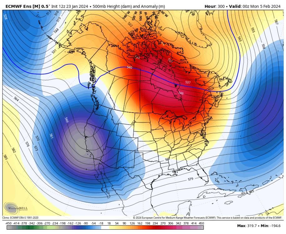
I'd like to hope for another round of cold and snow but I'm just not seeing any strong evidence for a -PNA pattern.
-
The two cases where I recall March performing exceptionally well in the PNW were 1951 and 2002. Both were cold neutral. I'd be very surprised to see a cold March in the PNW during a strong El Niño even with a SSW/PV split.
-
January Weather In The PNW 2024 (Part III) - The Warming Shot
AbbyJr replied to iFred's topic in West of the Rockies
Yay I'm learning. Thanks Phil. -
January Weather In The PNW 2024 (Part III) - The Warming Shot
AbbyJr replied to iFred's topic in West of the Rockies
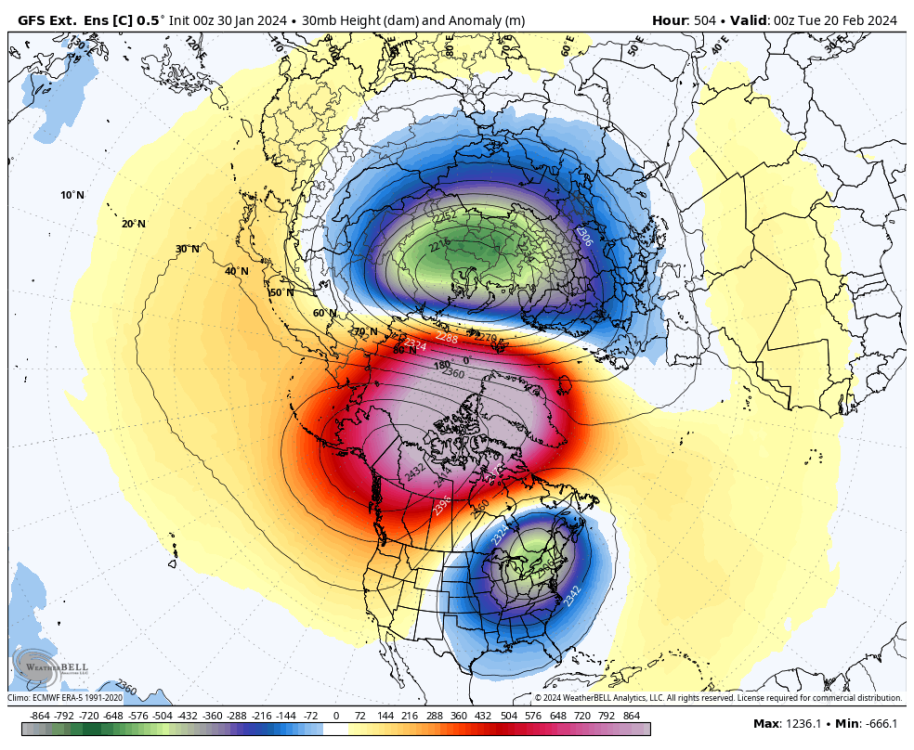
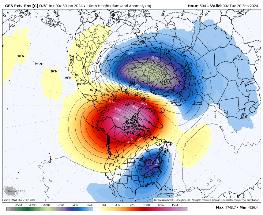
This, however, is a PV split, correct me if I'm wrong? By the way, I'm not saying this is likely to verify. Just pointing out the raw data.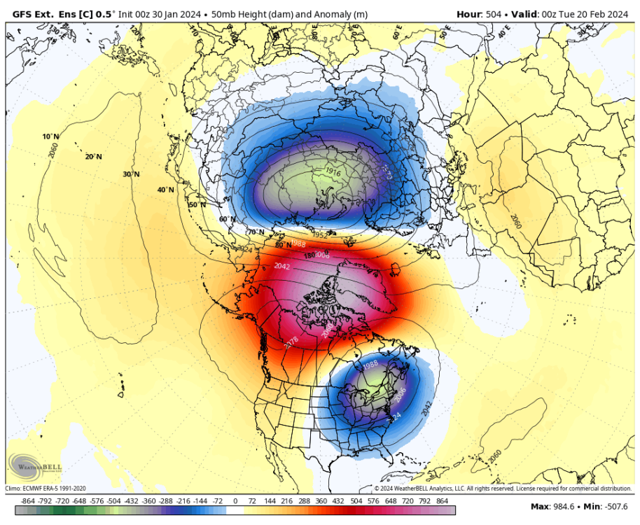
-
January Weather In The PNW 2024 (Part III) - The Warming Shot
AbbyJr replied to iFred's topic in West of the Rockies
Even if we only make it to neutral, that can still work out well for the PNW if the QBO goes positive. The 1990/91 winter was a neutral/+QBO and produced multiple top tier arctic blasts in the PNW. I've always understood that during neutral years, the ENSO doesn't really play a big role in the upper level pattern. Therefore, such winters can be full of wild swings. Do you think there is a good chance the QBO will go positive by next winter? -
January Weather In The PNW 2024 (Part III) - The Warming Shot
AbbyJr replied to iFred's topic in West of the Rockies
Could something similar to February 2018 be a possible solution for mid February in the PNW? -
January Weather In The PNW 2024 (Part III) - The Warming Shot
AbbyJr replied to iFred's topic in West of the Rockies
The good news is that we don't need a top tier arctic blast from a PV lobe in order to get cold and snow down to the lower elevations in SWBC. February 2017 was one example of how a medicre outflow event still produced a very snowy pattern in the low elevations. In fact, Abbotsford recorded its highest snow depth since December 2008 during that event. While temperatures were marginal, many areas saw significant snowfall as a low pressure system stalled off the Washington coast and interacted with a modified arctic airmass. Run of the mill cold but top tier snowfall was the outcome. -
January Weather In The PNW 2024 (Part III) - The Warming Shot
AbbyJr replied to iFred's topic in West of the Rockies
It's possible but there have been many La Niña events that did not feature an arctic outbreak in the PNW. -
January Weather In The PNW 2024 (Part III) - The Warming Shot
AbbyJr replied to iFred's topic in West of the Rockies
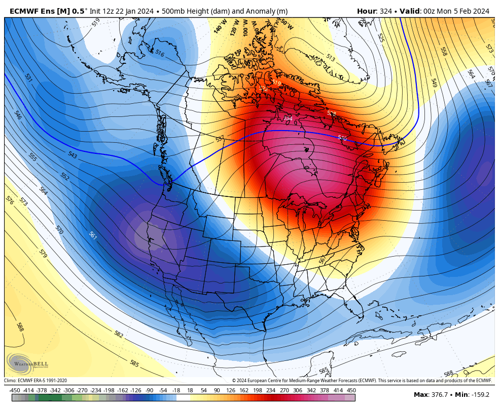
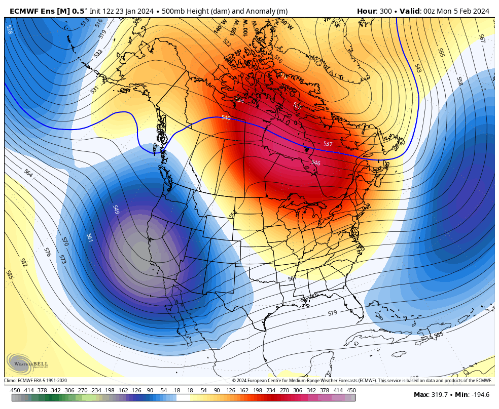
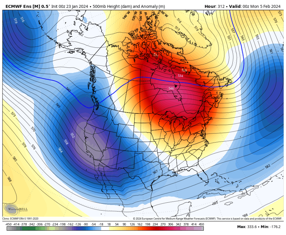
Trends? 12Z Today: 00Z Last Night: 12Z Yesterday:
-
January Weather In The PNW 2024 (Part III) - The Warming Shot
AbbyJr replied to iFred's topic in West of the Rockies
There is a good chance the PNW could get chilly in mid to late February but I'd be surprised to see any legit arctic air. -
January Weather In The PNW 2024 (Part III) - The Warming Shot
AbbyJr replied to iFred's topic in West of the Rockies
Agreed. But I think next winter has a lot of potential if we do end up crashing back into La Niña and the QBO goes westerly. La Niña/+QBO is usually a good combo for PNW cold. -
January Weather In The PNW 2024 (Part III) - The Warming Shot
AbbyJr replied to iFred's topic in West of the Rockies
It’s extremely rare but March has sometimes performed in the PNW. 1951 and 2002 are a couple examples. Though they were both cold neutral. This year we have a strong El Niño making a cold outcome much less likely. -
January Weather In The PNW 2024 (Part III) - The Warming Shot
AbbyJr replied to iFred's topic in West of the Rockies
At least North America was able to score mid January with that SSW event. Back to El Niño. -
January Weather In The PNW 2024 (Part III) - The Warming Shot
AbbyJr replied to iFred's topic in West of the Rockies
The big thaw is happening here too. We are all in this together.