


NH4NU
-
Posts
280 -
Joined
-
Last visited
Everything posted by NH4NU
-
Papillion/Omaha has fallen in a nice place as this second “wave” moves in from the north. Hasn’t stopped snowing since it transitioned around 4/415p. Coming down at a moderate rate and very windy!
-
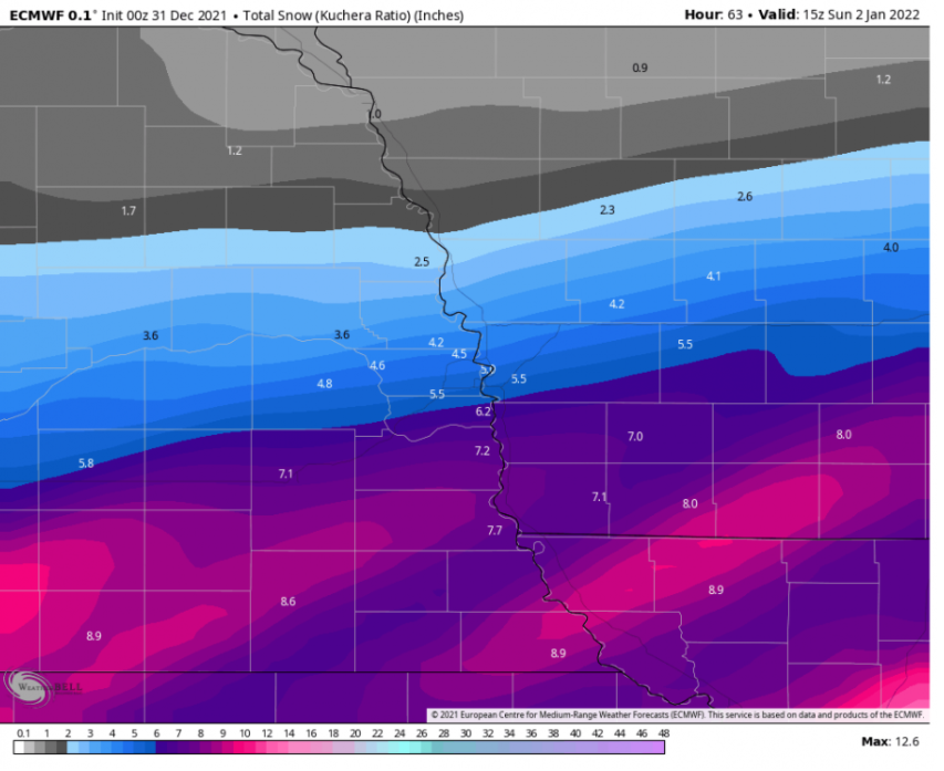
Although it's not a "Kuchera vs Kuchera" #1: Wednesday 00z run (72hrs out from onset) #2: Tonight's 00z run

-
With all do respect, have you looked at where the massive pool of dry air is setting up? Models have always struggled with dry air, and that sharp cutoff is more than likely a hint as to where that line is. Heaviest axis of snow typically sets up, just northwest of that axis.
-
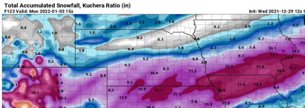
@Bellona From this morning. Hope this helps!
-
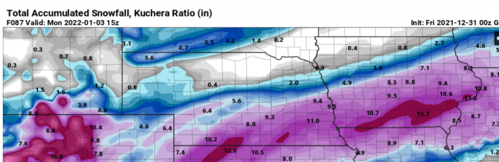
Barb's Rule Image #1 is GFS afternoon Wednesday Image #2 is GFS 00z Tonight #patterns&trends
-
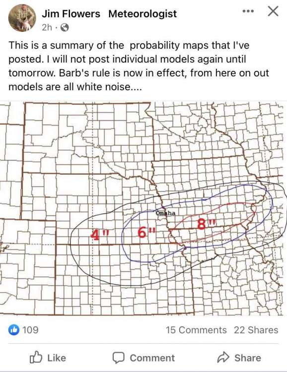
5-County coming in clutch with the Barb's Rule backup!
-
I legit miss Craig hahah!
-
Bummer that you don't remember me, because we used to interact often on this blog, back to the Craig McPeck days! Very touchy timeframe we are in here, I get it. Happy New Years!
-
Lol. Makes me "so happy". I am not a wishcaster for where I live. I would assume with those probability maps that you go off of the 40-60% category for zoning purposes, right?
-
I have been a member of this blog since 2014 sir. I wish someone would have told me years ago, to not stress run to run, but instead monitor trends.
-
We're still going model by model I see...
-
I recommend following his Facebook page, he has multiple videos on this question. He’s an old school guy (before reliance on weather models). He came up with “Barbs Rule” (who is his wife haha) many years ago which ultimately says 3 days prior to event, step away from models and begin monitoring things like surface track and trends, checking out different NWS agencies where the storm is currently located for their local observations, etc. After 7 consecutive EURO runs followed by 12z GFS coming more in line with it yesterday afternoon (72 hours out) no more models. He even predicted yesterdays evening runs would shift their track. Has this method failed over the years? Yes. But I’ve followed him for 15 years now and he wins more times than not. You can use the updated 12z NAM as an example of this method.
-
I’m all in with Jim here. Best practice has always been to scrap models this close to event onset.
-
Mainly because I’m bias for OMA/LNK, I have to get on board with “Barbs Rule”. If you know, you know. Toss models out once you reach 3 days prior to event onset.
-
What in the 00z NAM is happening here?
-
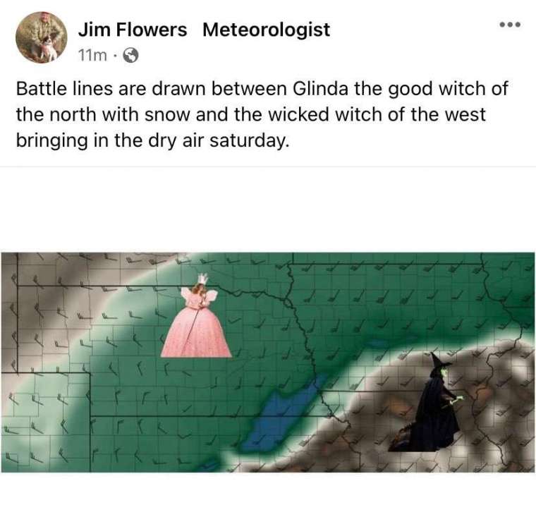
Got to love Jim! Liking that the dry air has shifted a tad south and away from eastern Neb which feels like a rarity.
-
Continuing to snow heavily and wind has increased here in Papillion!
-

-
Watching Bill Randby now and he is saying snow may linger all the way into 9a tomorrow. Additional 7-9" on top of what we already have now, and like 10-16" totals!
-
I just drove from Regency in Omaha to Papillion and it is absolutely treacherous out! Cannot see the road in may places, cars stuck all along Pacific, coming down like crazy! What an awesome storm!!
-
00z NAM throwing curveballs for Omaha! 5-7"? What?
-
Afternoon EURO now thinking 2-4" for Omaha and surrounding counties.
-
Mesoscale concerning Moderate and occasionally Heavy snow issued for a large chunk of eastern and southeastern Nebraska. Storm continues to look great! https://www.spc.noaa.gov/products/md/md1884.html
-
Why are you thinking this? Everything is lining up aside the fact that we got more snow than anticipated thus far. Radar trends look fine!
-
I just measured and I have right at 3" near Settler's Creek in Papillion!


