jaster220
-
Posts
12212 -
Joined
-
Last visited
-
Days Won
59
Everything posted by jaster220
-
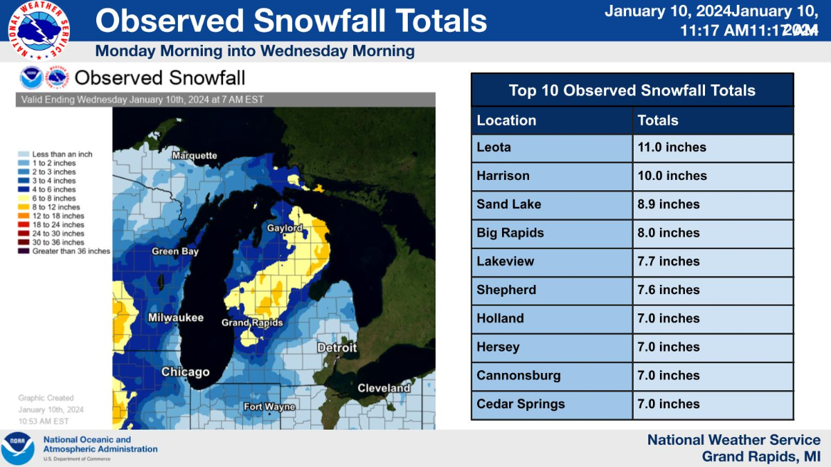
Almost scored top honors for GRR's region. Not sure where exactly that measurement comes from here in Harrison, but just eye-balling plow banks along the x-way looks more like 12" from here and the next 8 miles north. So, once again the globals beat the NAM's silly scenario(s) and the last-minute bump on the Euro and GFS was a legit trend. Super pleased with everything except my NWS office's headline and statement that "nobody in their CWA was expected to reach the 7" in 24 hrs Warning threshold". Well, we had at least 10" in that time. Yes, I'd rather have the bigger snows ofc, but "come on man" they are the paid experts and miss the mark regularly regarding synoptic systems.

-
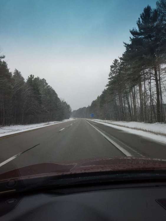
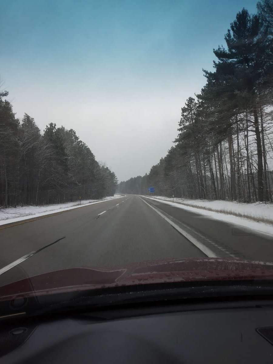
Can confirm after driving about 80 miles this evening. Fairly disappointing for most of Michigan, but still a respectable first storm of any season. Looks like at least 8" has fallen here, but due to compaction it is sitting more like a solid 6 or 7" storm. Very much the flavor of a November storm for NMI. @East Dubzz's photo of the trees plastered pretty much how it looks here as well.
-
GRR's map has my place under 8-12", but a WWA ofc. Just another day of life in an obscure corner of their CWA. Feels just like old times
-
Last minute "at the buzzer" rally?? Suddenly both Euro and GFS have me well into dbl digits up here. Cautiously optimistic as I try to get some zzz's. Going to be much slower commute tomorrow.
-
PS - Euro is sexy, even if my offices seem to be ignoring it, lol
-
Thought I'd never see a forecast like this AGAIN, the way things have been.
-
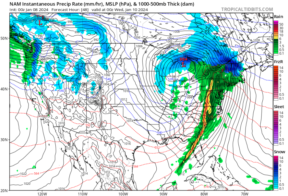
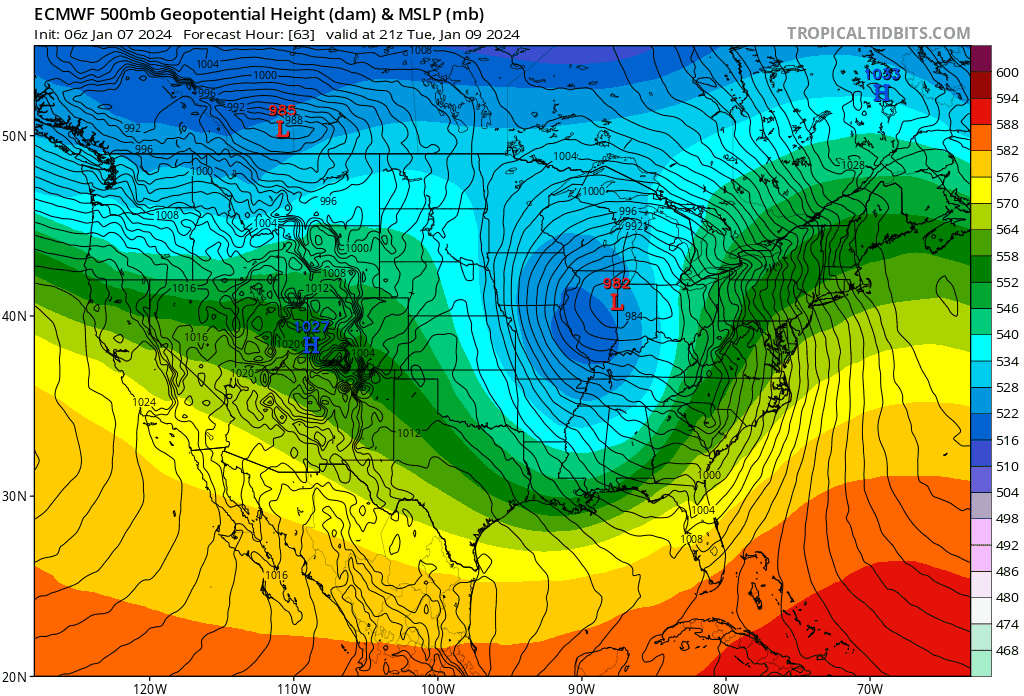
0z NAM has the LOW about 300 miles north of where this morning's GEM had it at 7 pm Tuesday evening.
-
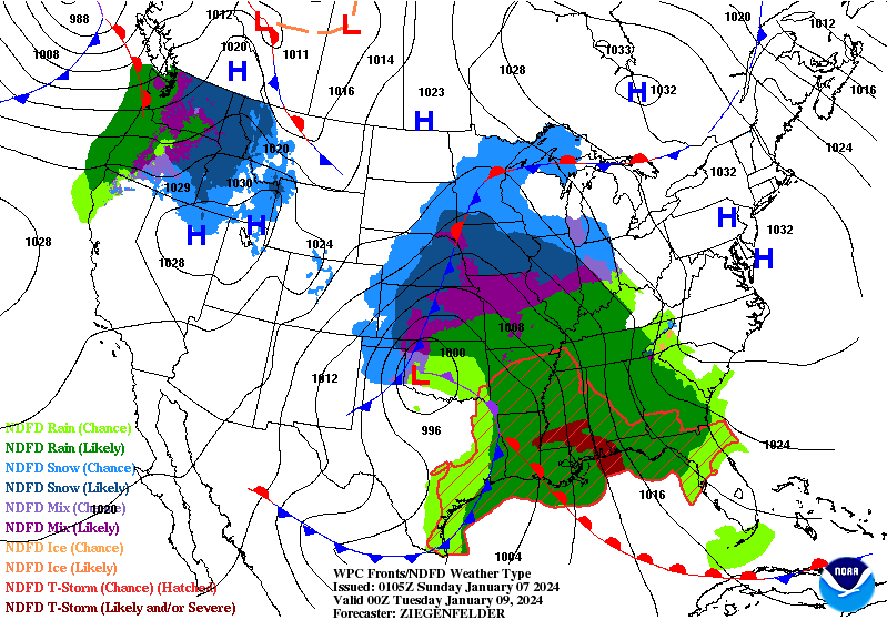
Yep, not a boring blank CONUS map any more, is it? #webeactivewx
-
Looking at the models, this SLP comes off the mountain west just explodes with puking snow rates. Crazy. Not sure why even. It deepens up our way but loses that heaviest precip pattern pretty quickly. Thump snows I've seen only a handful of times in all my years. Should be a great event (#2) out your way.
-
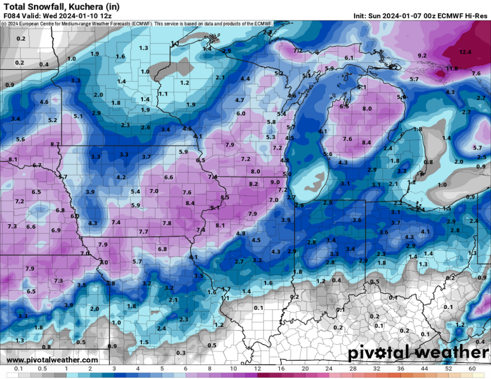
Even the HOT NAM Kuchera maps showing 5" for you in N Kent. May never be that much on the level due to warmth. Reminds me of the Feb 2016 strong storm that had marginal temps. I got 11.6" in Marshall and had about 8" OTG after all the melt and compaction. Had the temps been low 20s, that would've been a 15+ Big Dog. Right now, I sit in a more favorable position here in the Northland. Also curious to see if my increased elevation helps out at all? There is about a 350 foot increase from the south end of the county.
-
18z EPS says WPC shoulda stuck to their original d7 forecast, lol
-
How so?
-
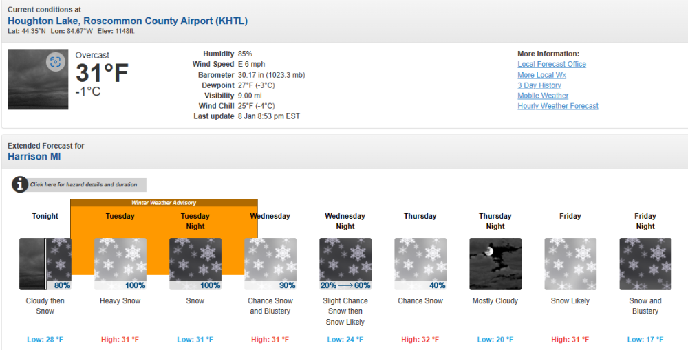
GRR likes (loves?) me! .LONG TERM...(Monday night through Saturday) Issued at 400 AM EST Sun Jan 7 2024 - Risk for impacts continues late Monday night into Wednesday morning A burst of warm air advection associated with the arrival of the low level jet arrives later Monday night into Tuesday morning. Stronger deep upward vertical motion is seen in the models so this event will likely start off with a period of accumulating snow. The Tuesday morning commute could be treacherous as several inches of snow may fall then. Warmer air up at around 850 mb is still seen to lift northward through the southern half of the CWA Tuesday afternoon which should transition the precipitation over to a mix of rain/snow or just plain rain. Further north that above freezing layer may not reach our northern zones so it should remain mainly snow up there. We could see a lull in the heavier/steady precipitation for part of Tuesday afternoon as a mid level dry slot lifts in. However during the evening and into the night the deepening closed low pulls east of the region. Its associated deformation zone pulls in from the west and that will support an increase in the precipitation once again. All areas will change back to snow and that could support impacts expanding once again into the Wednesday morning commute. Winds will also be on the increase and gusts are likely to top 25 mph. Northern zones will end up with the most snow and impacts with an increased potential for more than 6 inches there.
-
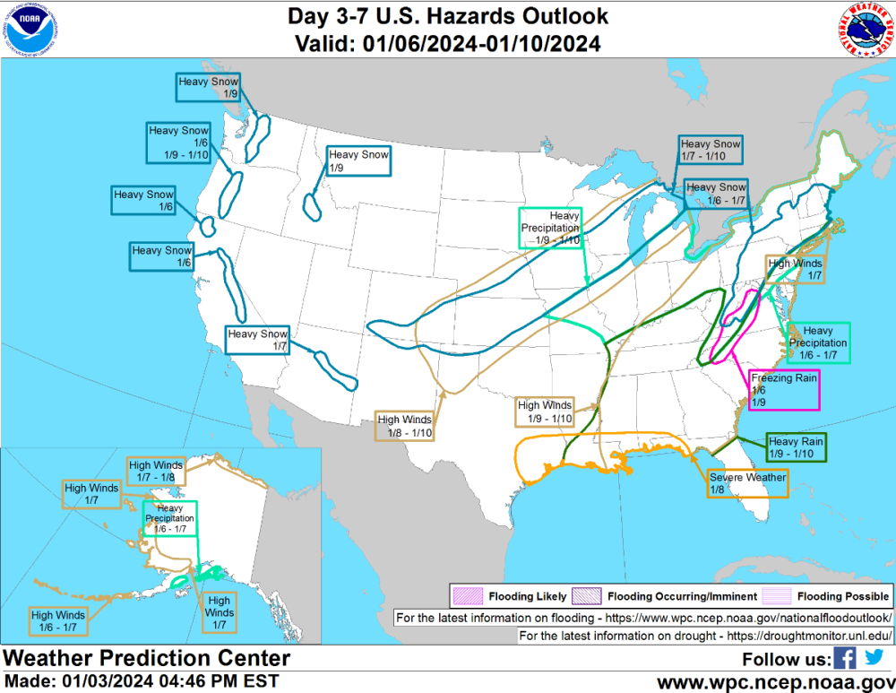
Bliz Warnings showing up now in Eastern CO and NE NM. URGENT - WINTER WEATHER MESSAGE National Weather Service Albuquerque NM 415 AM MST Sun Jan 7 2024 NMZ227-228-230-071830- /O.UPG.KABQ.WS.A.0003.240108T0900Z-240109T1200Z/ /O.NEW.KABQ.BZ.W.0001.240108T0900Z-240109T1200Z/ Johnson and Bartlett Mesas Including Raton Pass-Far Northeast Highlands-Union County- 415 AM MST Sun Jan 7 2024 ...BLIZZARD WARNING IN EFFECT FROM 2 AM MONDAY TO 5 AM MST TUESDAY... * WHAT...Blizzard conditions expected. Total snow accumulations of 2 to 5 inches for most, with 6 to 12 inches across Raton Pass and Capulin. Some locally higher amounts are possible. Winds gusting as high as 65 mph. * WHERE...Far Northeast Highlands, Johnson and Bartlett Mesas Including Raton Pass, and Union County. * WHEN...From 2 AM Monday to 5 AM MST Tuesday. * IMPACTS...Travel could be very difficult to impossible. Some roads will likely be closed. Significant travel delays are possible. Widespread blowing snow could significantly reduce visibility and cause whiteout conditions. Very strong winds could cause extensive damage to trees and power lines. * ADDITIONAL DETAILS...The heaviest snowfall and strongest winds are expected during the day Monday. Areas of blowing snow are still possible Monday night after the snowfall ends. PRECAUTIONARY/PREPAREDNESS ACTIONS... Travel should be restricted to emergencies only. If you must travel, have a winter survival kit with you. If you get stranded, stay with your vehicle. For the latest road conditions, dial 511 or 1.800.432.4269, or visit http://nmroads.com. && $$ URGENT - WINTER WEATHER MESSAGE National Weather Service Pueblo CO 410 AM MST Sun Jan 7 2024 COZ074-071915- /O.UPG.KPUB.WS.A.0002.240108T0600Z-240109T0600Z/ /O.NEW.KPUB.BZ.W.0001.240108T0900Z-240109T1200Z/ Southern Sangre de Cristo Mountains Between 7500 and 11000 Feet- 410 AM MST Sun Jan 7 2024 ...BLIZZARD WARNING IN EFFECT FROM 2 AM MONDAY TO 5 AM MST TUESDAY... * WHAT...Blizzard conditions expected. Total snow accumulations of 4 to 14 inches. Locally higher amounts are possible. Winds gusting as high as 60 mph. * WHERE...Southern Sangre de Cristo Mountains Between 7500 and 11000 Feet. * WHEN...From 2 AM Monday to 5 AM MST Tuesday. * IMPACTS...Travel could be very difficult. Blowing snow could significantly reduce visibility. The hazardous conditions could impact the morning or evening commute. Strong winds could cause tree damage. The cold wind chills as low as 20 below zero could cause frostbite on exposed skin in as little as 30 minutes. PRECAUTIONARY/PREPAREDNESS ACTIONS... Travel should be restricted to emergencies only. If you must travel, have a winter survival kit with you. If you get stranded, stay with your vehicle. The latest road conditions for the state you are calling from can be obtained by calling 5 1 1.
-
Looks a LOT like the Euro for my region.
-
While the GEM tracks the SLP furthest south, it ends up similar with a mid-970s Low in Huron like the Euro. I'm hoping that the Euro scores the coup over the N trended models. It's 0z snowfall map was just about ideal for my new backyard.
-
LOL, I just remembered I have no snow shovel here. I have an extra day to shop for that tho
-
Last bullet point translation "moving onto the next one then" Sorry for the last-minute rug pull. Had a few the past 3 winters living in metro Detroit.
-
I liked this part of APX's notes on this storm PRIMARY FORECAST CONCERNS: Tuesday system: We are continuing to monitor a potent system expected to track into the region for Tuesday. Guidance seems to be holding onto a cooler solution and is pulling colder air in with deep moisture from the Gulf. This increases the probability of widespread snow occurring across the region for this system. However, depending on the track, easterly winds could kick in and give way to the possibility of rain mixing in. One thing worth noting is that guidance has trended to a more northwest track, making the eastern portion of the mitt more susceptible to rain mixing in with the aforementioned easterly winds. Exact accumulations are still very much uncertain at this time, but it should be mentioned that there is a potential for 4 to 8 inches of snowfall through Tuesday evening across the region. With gusty winds accompanying this system, this poses the threat of blowing snow occurring even though the snow is expected to be very wet and dense in nature (which is perfect for building a snowman!). Nonetheless, the development of hazardous travel will certainly be possible. This storm will hold it`s grip on the region through Tuesday night and possibly into Wednesday, but the evolution and track of this system is still uncertain so this is subject to change.
-
Totally get it. I am a SEMI native and WMI always did better with these S Stream large synoptic storms. It is partly the track, and while not as dramatic a situation as Chicago has right on Lake Michigan, SEMI has Erie, St. Clair, and Huron all sitting to it's E/SE/NE mitigating any colder air during the usual easterly wind fetch in a large snowstorm. SEMI, especially bottom corner, does best in an overwhelmingly cold winter pattern but almost always gets screwed in these warmer/marginal cold winters.
-

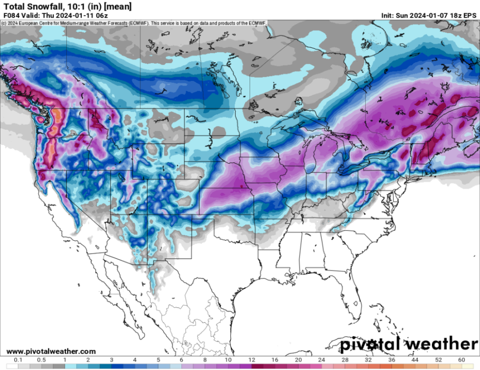
January 11-13 Major Winter Storm/Blizzard
jaster220 replied to Hoosier's topic in East of the Rockies
0z GFS still has a powerhouse -
I love how the defo-band/comma head basically rakes on MO and IL, then promptly dies over MI.
-
WPC with the southern track, but kinda Grinchy with a large area of mix just north of the SLP
-
Remembering the January 1999 Major Snowstorm -- 25 Years Later
jaster220 replied to Hoosier's topic in East of the Rockies
AWESOME! Thanks -
January 2024 Observations and Discussion
jaster220 replied to Minny_Weather's topic in East of the Rockies
My afternoon commute home from work featured some icy spots and a fresh coating of snow. Teaser for next week?