Search the Community
Showing results for tags 'high pressure'.
Found 1 result
-

The Reno Ridge: Extended Forecast
PRISM posted a topic in Climate, World Weather, and Earth Sciences
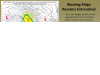
Hi all: Not certain just how long long range means but thought this topic relevant. The follow is from the NWS and some of you may find it interesting: From: Chris Smallcomb - NOAA Federal [mailto:chris.smallcomb@noaa.gov] Sent: Tuesday, January 14, 2014 8:32 AM To: _NWS WR REV EM Partners; _NWS WR REV Hydro Patrtners Subject: NWS Reno -- Long Range Outlook Remains Dry Good morning all. Normally I try to reserve these messages for storms, floods, and other weather events of significance. But clearly the lack of storms is becoming the event of significance in our region and is resulting in negative impacts to water supply and economy. Unfortunately I don't have good news on the storm front. Here's what we're seeing this Tuesday morning -- Our latest long range diagnostics continue to point toward high confidence in a blocking ridge of high pressure over California and Nevada through at least mid to late next week. This will shift the storm track well north of the area. This ridge is unusually strong and persistent - and to be honest we don't really know why it's been this way this winter.There is a chance, albeit small, of a weak low pressure storm squeaking in under the ridge and producing some light precipitation in the Sierra and slightly increased winds next week but confidence is low. In general light winds and weak-moderate valley inversions will be the rule.This lack of precipitation is certainly cause for concern regarding drought. The US Drought Monitor update will be posted this Thursday morning. Please check it out then at http://droughtmonitor.unl.edu/ Our super long range outlooks into February and March are still uncertain - no favored outcome between above and below normal precipitation. But honestly at this point it's going to take a number of big storms to make up the precipitation deficit we now have in the Sierra. That's what we have for now. Definitely let me know if you have questions or need specific info. Attached is a graphic showing one of the neat new tools we use to do long range forecasts - looking specifically at this blocking high pressure ridge. -Chris --- Chris Smallcomb Warning Coordination Met NWS Reno - 775.673.8100 x223