Search the Community
Showing results for tags 'Contains Detailed Records'.
Found 1 result
-
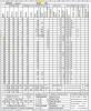
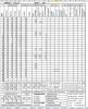
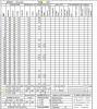
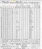
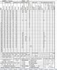
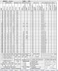
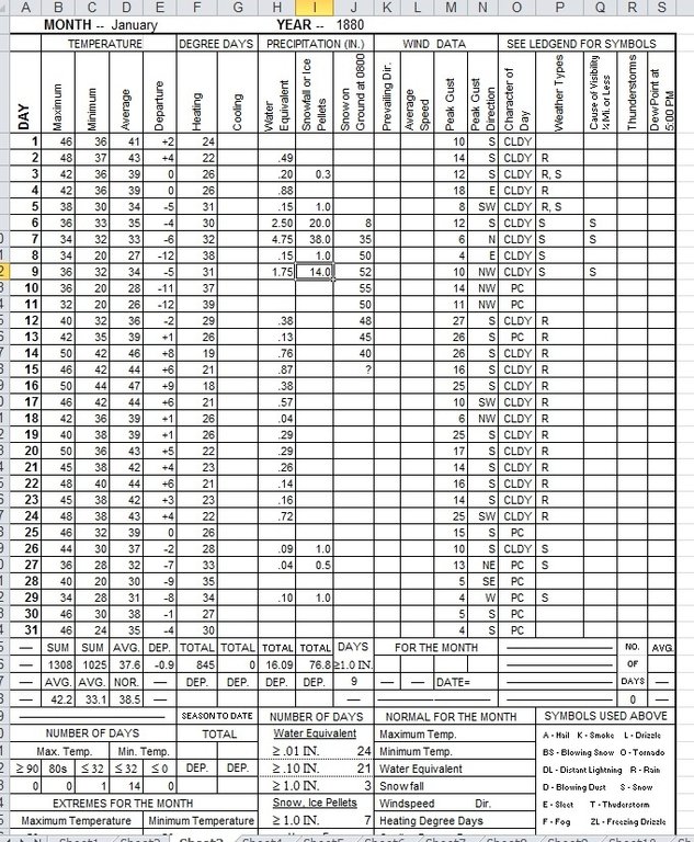
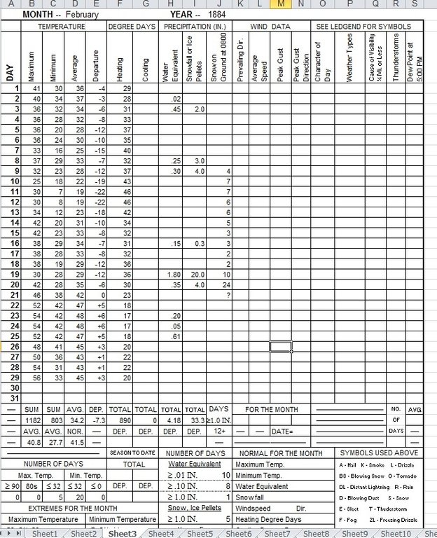
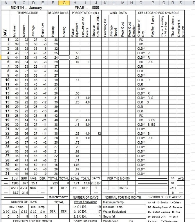
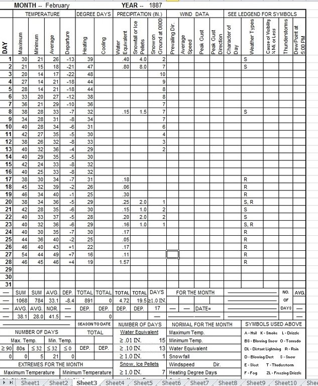
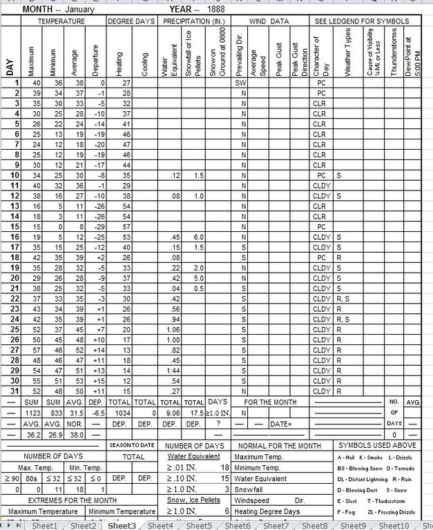
 I've had some requests to post detailed records for some of these amazing months in the past so I will begin with the 1880s. An absolutely amazing decade for both cold and snow throughout the Western Lowlands. It still puzzles me why that period of time had huge amounts of snow with nearly every Arctic blast. The months I will go into are Jan 1880, Feb 1884, Dec 1884, Jan 1886, Feb 1887, and Jan 1888. Combined those months had an astonishing 195.6 inches of snow and 45 daily maximum temperatures of 32 or lower. These are the best months of that amazing decade, but there were others with lesser cold and or snow events. January 1880 - The tremendous amounts of snow that month were cause by a combination of two extremely deep low pressure centers tracking over SW and south Central WA in combination with a prolific baroclinic band that produced extraordinarily heavy snowfall rates for at least 48 hours straight. There was enough cold air available for all of the precip to fall as snow thanks to an Arctic outbreak in late December which left plenty of residual cold over SW BC. The interaction between the baroclinic band and the Arctic air not only cause record shattering snowfall, but it also produced near all time record water equivalent rates and that's really saying something! The Puget Sound region from Tacoma to Port Townsend had snow depths ultimately reach 4.5 to 6 feet. One can only wonder how places away from the water with a bit of elevation may have fared! The weather records for January 1880 seen below are a composite of Bainbridge Island (temperature and all of the water equivalent data except for the days during the massive snow event), Seattle (snowfall based on accounts from the P-I newspaper, and water equivalent for the snowstorm based on data stating the snow pack weighed 52 pounds per square foot), and Olympia (sky condition and wind data). The wind data from Olympia may not have been representative of Seattle on some days, however. February 1884 - Data derived from Bainbridge Island records. Seattle was similar based on newspaper accounts. This would arguably be my pick for the best February on record with a combination of very cold temps and heavy long lasting snow cover. Nearly two feet of snow on the ground on my birthday! December 1884 - Data derived from observations from Tacoma. The records state the elevation at around 300 feet. Hands down the greatest December on record for the NW with long lasting cold and snow cover. January 1886 - Records from Tacoma. A nice solid cold / snow event that beats any January at least since 1980 and probably since 1972 or even 1969. February 1887 - Records from Tacoma. A really nice Arctic blast / snow event that beats any February in recent memory. January 1888 - Records from Tacoma. Featured what is easily one of the top five Arctic air masses to strike the NW since record keeping for the region began in 1850. The fact it dropped to zero at a location near Puget Sound and on a hill attests to how bitter that blast was. One day had a 2 pm temperature of 9 degrees. EDIT...It appears the months are showing in the opposite order of how I uploaded them. Oh well...