Meichel
-
Posts
123 -
Joined
-
Last visited
Posts posted by Meichel
-
-
000
FXUS63 KAPX 120117
AFDAPX
Area Forecast Discussion
National Weather Service Gaylord MI
817 PM EST Mon Nov 11 2019
.UPDATE...
Issued at 816 PM EST Mon Nov 11 2019
The poor, poor Leelanau-Benzie coastline continues to be hit hard
by the dominant lake effect snow band. Total accums must be
pushing 2 feet in parts of western Leelanau Co. We keep waiting
for this band to shift eastward; that shift is already well
underway with the upstream end of the band over Superior. The
models continue to slow the eastward shift over nw lower MI, but
it has to happen (right?), especially as increasing land breezes
likely spin up some sort of mesolow near Beaver Isl. Grids have
been adjusted for more snow early tonight where the band is
presently found, and don`t bring better snow showers into the Gd
Trav Bay region until closer to 1-2 am.
Seriously? LOL
-
So I'm up in Traverse City waiting patiently for the lake effect snow that was supposed to start 5 hours ago. Actually changed my work plans according to the (ever changing) forecast in this area, but in reality could have easily finished up and been in Ludington tonight. So I'll have to drive through it tomorrow instead.
-
 1
1
-
-
Drove in and out of the northern edge of the snow band from St Paul MN to Oshkosh WI. Had a short period of mixed precip around Osseo for 30 minutes or so. Coming down pretty good here in Oshkosh, ground almost covered. Wind is ridiculous!
-
3
-
-
Roughly 3" here in 60156. Still coming down, not looking forward to cleaning it with the layer of frozen crap underneath from when it started yesterday.
-
3
-
-
Grass not covered yet in 60156, as we sit in a lull before the heaviest stuff gets here. Bearing down on Tom right now, and DuPage County looks to be the big winner around Chicago. We should do pretty well out here, in spite of the 1/2" of sleet that started this off this morning.
-
About the same, but it melted off quickly...it was primarily a mood snow day....getting my psyche prepared for the winter season...
We were in that band and measured just under 2" when the pixie dust took over at the end. Was awesome to watch some pretty fat flakes for a couple hours!
-
2
-
-
Nice looking stuff in 60156!
-
6
-
-
Getting ready to head up to Schaumburg. Big flakes flying, as wintry as you can get out there
Is that where your accounts are? Mine are all within a couple blocks of I90, between Roselle Rd & Meacham Rd.
-
A nice weenie band just blossomed across Kane/DuPage/N Cook which has some nice 20-25dbz returns...big fatty flakes just beginning to fly over here....this just adds to the beautiful wintry scene across Chicagoland....
http://climate.cod.edu/data/nexrad/LOT/N0Q/LOT.N0Q.20180210.1446.gif
Looks like I'm getting clipped by that band, and my flakes just changed from fat and fluffy back to pixie dust.
Edit: had a much smaller 20-25 dbz band that's already dissipated.
-
Nice! How have you been? Haven't seen you on here in a while. Glad to hear your cashin' in...btw, what did you end up with yesterday??
I'm good, thanks.
No official measurement yesterday, as I was out in the storm, but the official Crystal Lake total of 6" seemed accurate. I hate pixie dust. Stuff stacks too well. Shoveling wasn't fun. It was just too wet, air temp rose from around 20F to 25F during the highest snowfall rates. Seems to be why most of the accumulation forecasts ended up low-end.
-
1
-
-
I'm hearing reports of up to 3" in McHenry county...just a dusting over here...looks like northern burbs got the best snow out of this wave...
I can confirm 3" and still snowing in Lake in the Hills.
-
1
-
-
Pixie dust falling for about 90 minutes IMBY, .25" so far. It's gonna have to continue until late afternoon to cover the grass unless it picks up.
But, still, Merry Christmas.
-
2
-
-
Anyone calculate a ratio by chance?
-
Steady, wet, med/small flakes here in SE McHenry county. Been snowing for a couple hours, just now starting to stick on paved surfaces. 32º
-
Not quite 9" here thus far. (Haven't cleaned my board off once though.) Pixie dust currently.
Shoveling that 1/2" of slush under the snow was a good workout!
-
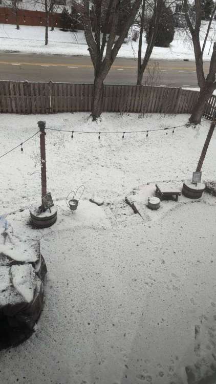
4"+ IMBY and still coming down at a good clip.
Surprise day off, and the kids are on Spring Break. Sledding it is!
-
1
-
-
Big ol band of LES stretching into SE McHenry Co right now.Only 0.3" in the last hour. Up to 14.8".
-
1
-
-
Rochester NY for work. Left Elgin at 745 this morning.Where are you heading?
@ Tom, yeah it's still snowing. Right now there's a small moderate band over head. The snow relaxes in between bands though.
-
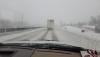
Almost to Rochester. Mixed bag up here. Buffalo was wet and sloppy for a mile or 2, then frozen and blowing. Back and forth for a good 50 miles. Roads are mostly good, glad it's SB Sunday as traffic has been light.
-
Wet and slushy here, almost to Erie, PA. Winds have shifted and are coming off the lake.
-
Just getting to Cleveland. Warmer here, roads are very clean Passed about 20 spinouts and accidents so far, only 1 serious one thankfully. Northern Indiana was absolutely the worst.
Now hearing Rochester (where I'm headed) will end up with 15".
-
2
-
-
Just left Elgin 30 minutes ago. I90 E isn't too horrible.
-
1
-
-
4.5" IMBY. Heavy, tiny, wet flakes. I'm leaving for Rochester, NY in about 10 minutes, driving right through this storm's snow belt. Hoping to stay ahead of the heavy stuff and winds. Will try to report along the way.
-
-SN here now.


1/8-1/10 Panhandle Hook
in East of the Rockies
Posted
Winter Wonder Bland in N IL