All Activity
- Past hour
-

October 2024 PNW Weather Discussion
Ken in Wood Village replied to TigerWoodsLibido's topic in West of the Rockies
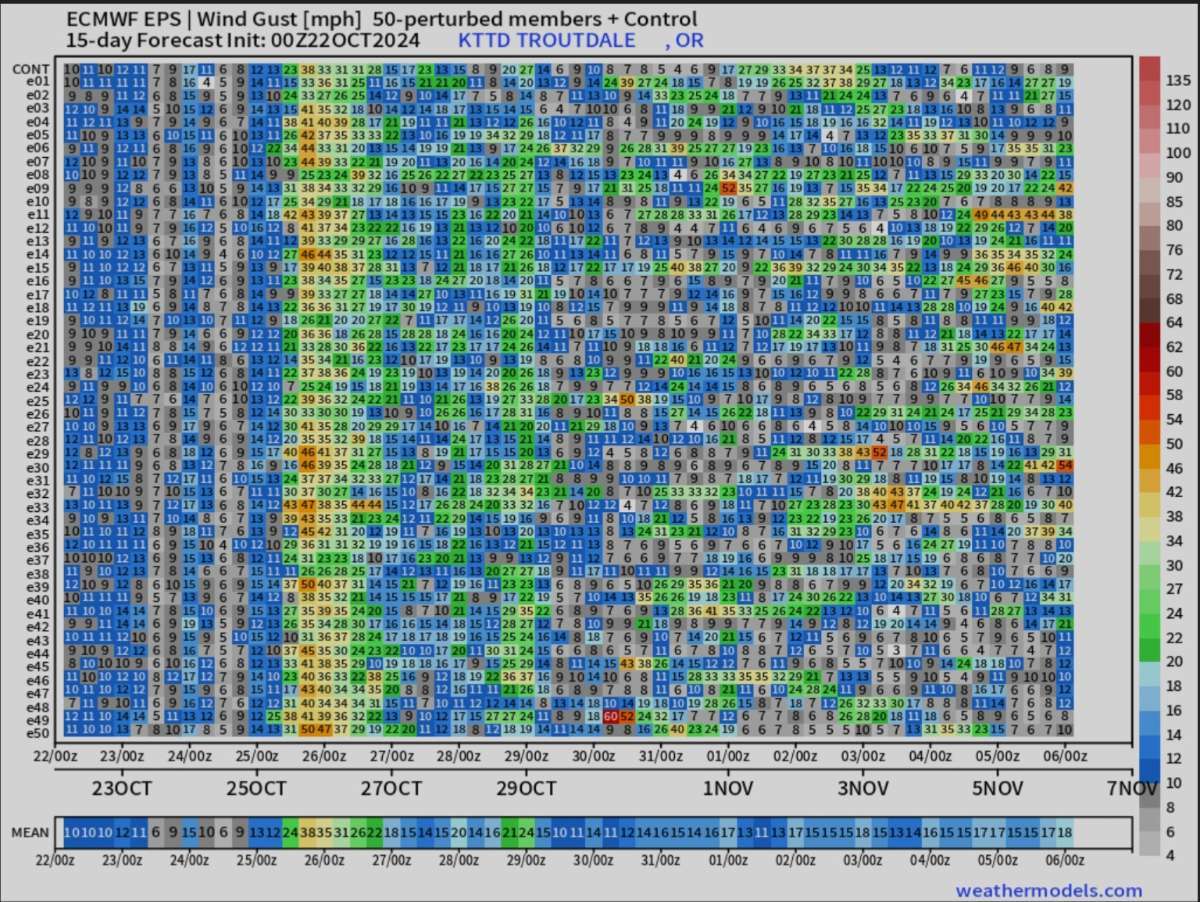
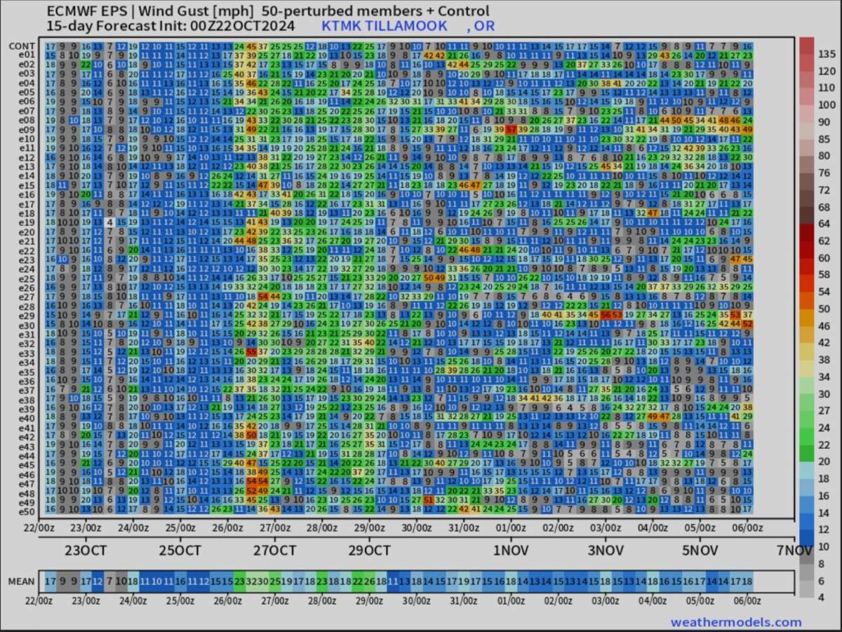
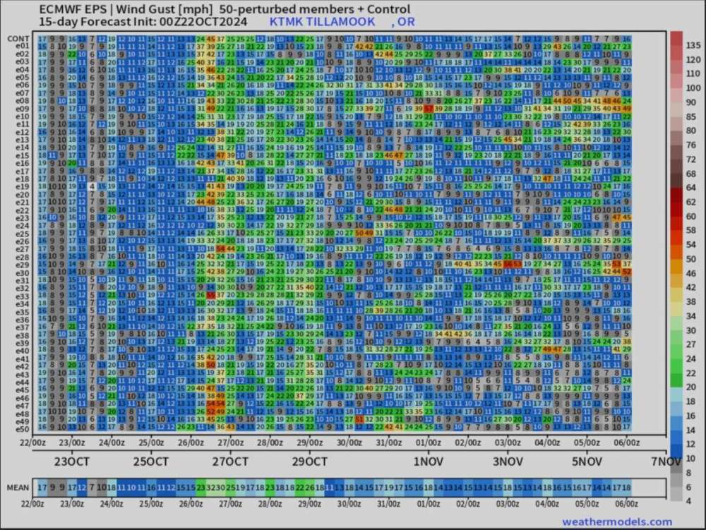
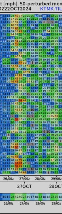
The EPS still showing a little wind event on the 26th maybe mine is a Eastwind event 🌬 but there is something showing up in the Tillamook area too.

-

October 2024 Observations and Discussion
AquariusRadar replied to westMJim's topic in East of the Rockies
The low pressure traversing Iowa and headed Northeast is not producing a lot of rain. Too much dry air along the path. But this could be a harbinger of good things to come. These systems that come out of the four corners region are traditionally good rain makers especially if they pull up lots of Gulf moisture ahead of the storm. But this one is not going to help the drought situation in Oklahoma Red River. -
Are we?

-
Areas are, yes. Election battles are bloodier. But we’re seeing many imports liking the way we do things and they vote for the status quo. Though not perfect, Texas is a study in good administration.
-
People are simply reacting to an existential need for an administrator that keeps their eyes on the road. Can you blame them? After several years of a mentally absent administrator, and a VP that yucks it up to 1/2 her questions, We the people are sick of it. It’s not complicated. Don't vote personality, vote skill. Hell , I can change the channel. No one overseas respects or fears Kamala. Most of the US finds her nauseating.
- Today
-

October 2024 PNW Weather Discussion
Tanis Leach replied to TigerWoodsLibido's topic in West of the Rockies
I was referring to 1915-16 based on who I was quoting. -
October 2024 PNW Weather Discussion
Tanis Leach replied to TigerWoodsLibido's topic in West of the Rockies
Dec 2013, Jan 1916, February 2014+2023, March 1951. There. Perfect winter. -
I'm really starting to feel the electricity of Election Day already.
-
The RNC has their sheit together this time. I know there are people in PA right now who have put their lives on hold to make sure Trump wins that state. The Republicans want this bad!
-

October 2024 PNW Weather Discussion
snow_wizard replied to TigerWoodsLibido's topic in West of the Rockies
I agree. This looks good on paper regardless. Nino is off the table so we don't have to worry about that. -
October 2024 PNW Weather Discussion
snow_wizard replied to TigerWoodsLibido's topic in West of the Rockies
That one was pretty epic. I still prefer Nov 1985 because of longer duration of cold and snow cover, but Dec 1990 was more bitterly cold. -
October 2024 PNW Weather Discussion
snow_wizard replied to TigerWoodsLibido's topic in West of the Rockies
Subsurface is still cold. All we need is a sustained trade wind burst and the Nina would be right there. -

October 2024 PNW Weather Discussion
Skagit Weather replied to TigerWoodsLibido's topic in West of the Rockies
Euro has a pretty intense convergence zone up in this area (Skagit/Snohomish line) Saturday into Sunday. Not much more than heavy rain, but looks like it could be whet where it sets up. -

October 2024 PNW Weather Discussion
Meatyorologist replied to TigerWoodsLibido's topic in West of the Rockies
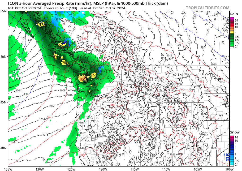
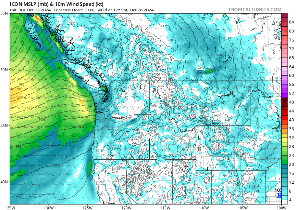
Almost missed the tightly packed low center in the sweet spot NE of the Olympics behind all that colorful precip. That would probably mean gusts to 50/hr-ish for KSEA. One potential outcome, though I doubt it. 'tis the icon
-

October 2024 PNW Weather Discussion
Tenochtitlan replied to TigerWoodsLibido's topic in West of the Rockies
2019-20 had a good January event in Bellingham. Pretty wild temperature swings the last day with sudden shifts from 30 to 45 and back again as the Arctic boundary kept changing its mind. -
October 2024 PNW Weather Discussion
Meatyorologist replied to TigerWoodsLibido's topic in West of the Rockies
ICON is reigny friday night -
October 2024 PNW Weather Discussion
Meatyorologist replied to TigerWoodsLibido's topic in West of the Rockies
If it ends up a neutral @Phil called it. -
October 2024 PNW Weather Discussion
snow drift replied to TigerWoodsLibido's topic in West of the Rockies
Maybe we transition next spring into la niña. -
October 2024 PNW Weather Discussion
Meatyorologist replied to TigerWoodsLibido's topic in West of the Rockies
Neutral or Niña, seems like a win-win in the analog pool. This winter has destiny attached to it. -

October 2024 PNW Weather Discussion
TigerWoodsLibido replied to TigerWoodsLibido's topic in West of the Rockies
Dec 2013 please. -

West Coast Sports Talk and Other Banter
Cold Snap replied to Anti Marine Layer's topic in West of the Rockies
I have Godwin on my fantasy team. Don’t know why he was in during garbage time. They weren’t coming back. -

October 2024 PNW Weather Discussion
smerfylicious replied to TigerWoodsLibido's topic in West of the Rockies
I'll take a 1990 thank you very much. -
October 2024 PNW Weather Discussion
snow_wizard replied to TigerWoodsLibido's topic in West of the Rockies
I think that was 2016-17. 2015-16 was a Nino. -
October 2024 PNW Weather Discussion
snow_wizard replied to TigerWoodsLibido's topic in West of the Rockies
I got a couple of inches but it was short lived. -
October 2024 PNW Weather Discussion
snow_wizard replied to TigerWoodsLibido's topic in West of the Rockies
I mean earlier in the year. Interestingly NOAA hadn't backed off of the Nina prediction even in late summer. I presume they have now. This one is really an oddball. Almost every time the subsurface gets as cold as it has been this year we get a Nina. Some people consider the MEI to be a better gauge and it is in Nina territory. I really hope this means we avoid a Nino next year since the cold water has never gotten a chance to run its course.