AquariusRadar
-
Posts
324 -
Joined
-
Last visited
-
Days Won
1
AquariusRadar's Achievements
")


-
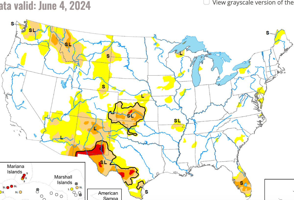
The NWS precipitation 10 day says the Tennessee Valley is predicted to get some good rains. Texas not so much. A new but small area of exceptional drought is noted in western Montana. With the execption of the Mississippi, almost all of the headwaters of our major rivers are dry or in drought. The eastern dry expands somewhat.

-
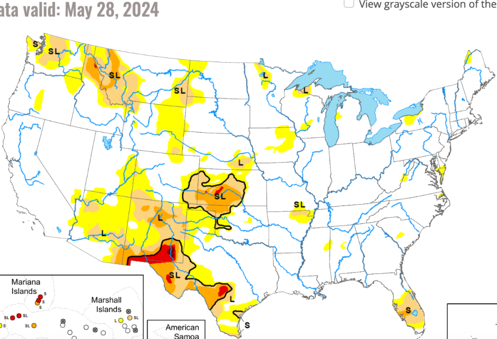
Surprisingly, extreme drought has pop up in Northern Virginia and few scattered locations in the Tennessee Valley. The western Montana drought now has a small patch of extreme conditions. Dry areas consume all of Oregon and seems to be expanding in norther California and Nevada. Overall the Northwest is very dry.
-
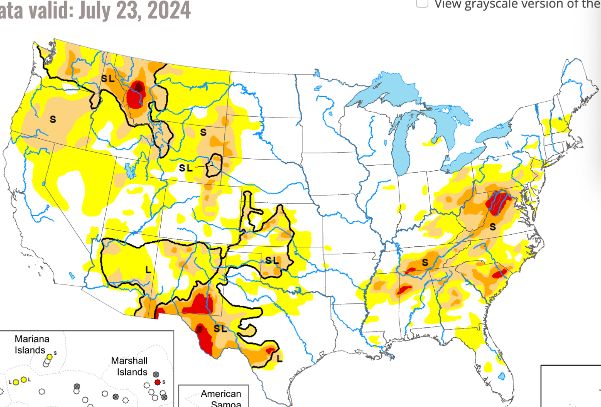
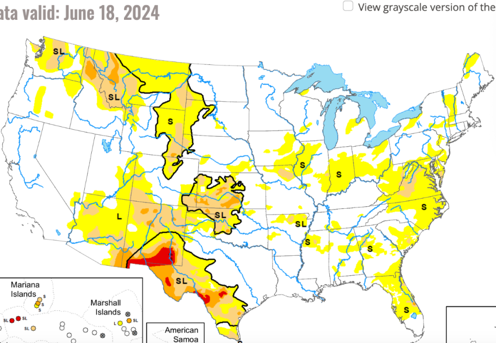
The drought areas of the eastern seaboard continues to grow. A small patch of extreme drought at the Carolinas border. The western droughts remain much the same. Beryl doesn't seem to have had a big impact on the dry areas.

-
Hurricane Season 2024
AquariusRadar replied to Andie's topic in Climate, World Weather, and Earth Sciences
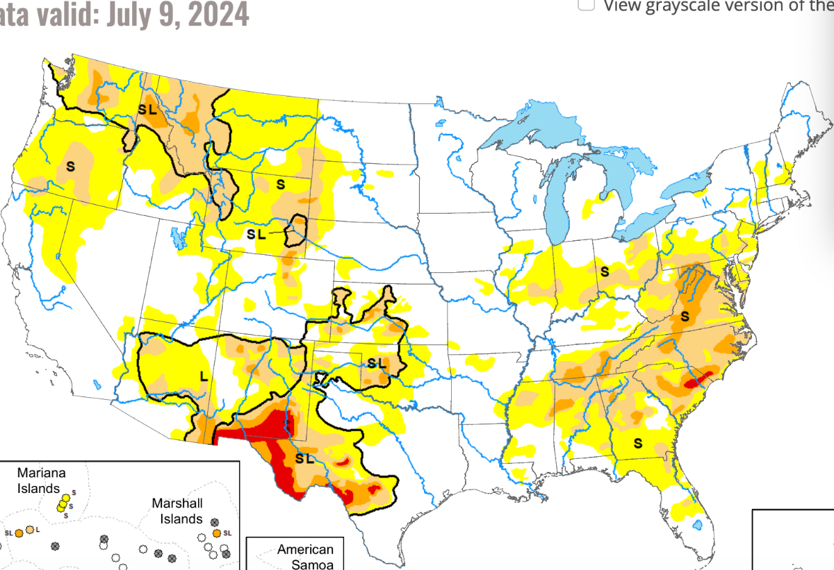
Beryl tip toed ashore in south Texas as a Cat 1. After a frightening run as a Cat 5, the weaker storm was a big relief for Texas. The rain will be helpful for the midsection of the country as it travels Northeast. Dry air surrounded the storm as it left the Yucatan peninsula and it never regained the power provided by water vapor. The descending dry air of 30º north means the end to hurricanes. -
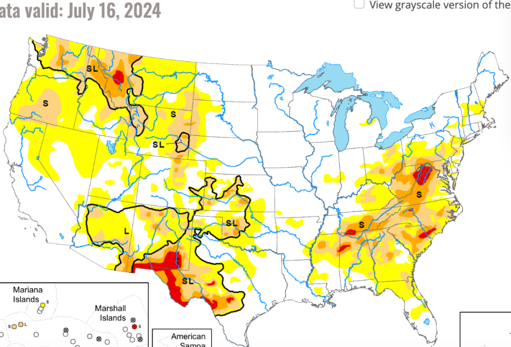
The extreme dry of the Eastern Seaboard continues to expand. Virginia, the Carolinas, and Georgia will be threatened by the ongoing heat of summer. The Montana drought lingers on and some areas experiancing extreme drought.

-
Drier conditions are expanding along the eastern seaboard. Drought remains unchanged in the West.

-
2024-2025 California and Southwest Weather Thread
AquariusRadar replied to Anti Marine Layer's topic in West of the Rockies
During this brief time period, I was trying out my psychic/magic weather powers: to invert the inversion and make the air cool and make the moisture of the blue Pacific rise to great height and pour down rain from lovely cumulonimbus on beautiful California; but to no avail as my weak powers could not hold off the marine layer as it return in force. AML discusses daily the most important weather phenomena: the marine layer. More important than cyclones, more powerful than tornados, more important than any weather factor. When we understand that what AML documents off the SoCal coast is happening over all the worlds oceans, we might start working on the problem of global warming. -
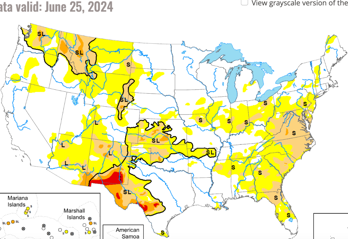
The serious drought has cleared in south Florida after some record rain and serious flooding. The drought in south Texas will find relief with the next weeks map as tropical storm Alberto is dumping lots of rain. Some coastal flooding. The corn belt is clear; just some dry areas remain. Kansas remains very dry with spotty drought. Montana dry is expanding some. New Mexico remians in drought.
-
2024 Hurricane Season
AquariusRadar replied to Andie's topic in Climate, World Weather, and Earth Sciences
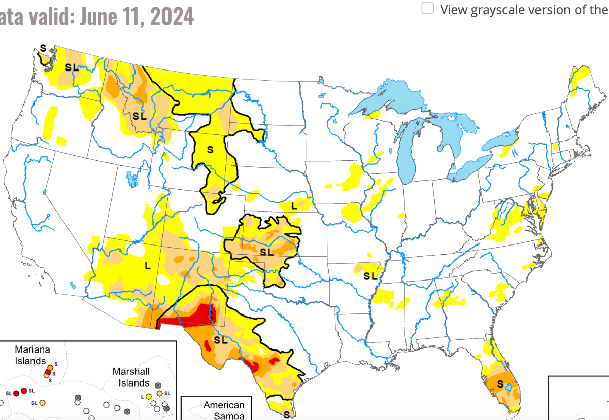
The first storm of the 2024 season has arrived ashore near the Texas/ Mexico border. Alberto, a moderate tropical storm has flooded some coastal areas of the Texas coast and is providing some much needed rain for south Texas. -
The dryness in Montana expands. The drought areas noted last week in south Florida remain on this week's map but should be much deminished on the next weeks map as torrential rain has inundated much of the area. Drought in the soutwest remains strong. Summer monsoon is approaching and will dampen the deserts. Kansas remains in the grip of a devastating drought.

-
An area of drought has crept up in south Florida including the Everglades. That wasn't anticipated, at least by me, in El Niño year as almost all of the southeast gets a soaking. Montana and Idaho drought continues. Mountain fires anticipated there later in the summer. West Texas drought expanded into the Laredo area of the Rio Grande. No change in Kansas or the southwest. This week marked the end of the parade of west to east storms along the Gulf Coast. Maybe El Niño is fading to the ENSO neutral?

-
2024 Hurricane Season
AquariusRadar replied to Andie's topic in Climate, World Weather, and Earth Sciences
I have always agreed that hurricanes need a combination of hot ocean below and cold air aloft. AML constantly reminds us that the marine layer is a big player in SoCal weather and so it is all over the ocean. I think the marine layer would be thicker as the temperature of air rises faster than the ocean surface. That's what we see with warming; the air temperature may increase 1.0 while ocean surface temps lag behind, increasing only 0.1. Along the ITCZ, I see lighting of thunderstorms only get active in the eary morning hours between midnight and daybreak. The air cools sufficiently to allow warm surface air, rich with water vapor, to rise and initiate the thunderstorm building. There are many other atmospheric factors involved of course, but with less optimum time to form thunderstorm clusters, I think hurricanes should be less frequent. With a large and well defined thunderstorm cluster and the right upper atmosphere, hurricanes will form just as readily as the storm itself keeps the upper air cool. This despite global warming and deeper marine layer. My idea may be trashed if the NOAA predictions for hurricane numbers for 2024 is correct. -
No offense taken OKwx2k4. You alluded to the "butterfly effect" in your review and in fact the entire concept is based on the work of Dr. Edward Lorentz and his mathematics work in the pursuit of weather study that eventually led to the development of chaos theory. I added my own experiance as an operator of high power radar systems. I must disagree with your assumption that "massive storms" come "as a surprise no matter what". The concept can only work because of the modern NWS weather surveillance system and forcasting tools that frequently point to the area of danger several days in advance and has real time monitoring of violent storms, regardless of the hilly terrain.
-
Drought continues in New Mexico and far west Texas. The south west is dry. The corn belt is now free of drought. The upper Mississippi is almost free of drought. Wheat country in the Texas panhandle and Kansas still under serious drought.
-
The heartland has been devastated by tornados this year. For twenty years I have sought to convince folks that microwave energy beamed directly at severe rotating storms can moderate those storms so they don't produce tornados. I'll not use the aquariusradar name but rather use the term storm moderation with microwave energy. Let me use another way to try and explain what I believe happens when storms are targeted with microwave energy. A large storm is approaching, and using all the observation details available, is given a danger value of 95 and increasing; storms that are producing tornados are given a value of 100+. The danger storm is surrounded by lesser CN clouds with values of 65, 78, 84, and similar values. CN clouds are always competing for moisture and the top competitor is largest. The danger cloud is boss, having all the necessary factors in very slight advantage over the other nearby storm clouds. When microwave energy is focused on the danger cloud base, a tiny heating of the moisture droplets and water vapor entering the cloud base makes them less likely to condense into larger droplets and thus they do not release thier heat of vaporization as readily. The danger CN cloud is hampered in development. But other nearby clouds now grow at the expense of the danger cloud. The CN cloud rated 65 grows to 72, the CN cloud rated 78 grows to 83 and so on. The danger cloud remains at 95 and if targeted long enough may begin to reduce in strength. Operating a microwave emitter (radar) to target a storm cloud can be done on a local basis; i.e., volunteer fire department or emergency management. It is now possible because of the NWS system prediction(s) are very accurate and local authorities can prepare in advance. EMS, law enforcement, and insurance companies can call upon state and federal authorities for science investigations into any idea they think might reduce the damages caused by tornados every year. Local Emergency Management Services needs more that sirens, phone apps, etc, tv alerts to help save lives and property during tornado season. The nation has all the necessary equipment and personnel to do analysis and testing to show that microwave heating (moderation) of storm clouds can reduce tornado damage.